Thames River (Ontario)
| Thames River | |
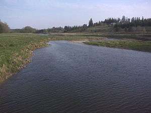 North Thames River, just upstream from the confluence with the Avon River near Stratford, Ontario | |
| Name origin: after the River Thames in England | |
| Country | Canada |
|---|---|
| Province | Ontario |
| Region | Southwestern Ontario |
| Part of | Great Lakes Basin |
| Source | |
| - location | Near Tavistock |
| Mouth | Lake Saint Clair |
| - location | Lighthouse Cove |
| - elevation | 173 m (568 ft) [1] |
| - coordinates | 42°19′9″N 82°27′15″W / 42.31917°N 82.45417°WCoordinates: 42°19′9″N 82°27′15″W / 42.31917°N 82.45417°W [2] |
| Length | 273 km (170 mi) [3] |
| Basin | 5,825 km2 (2,249 sq mi) [3] |
| Discharge | for Chatham |
| - average | 52.9 m3/s (1,868 cu ft/s) [4] |
| - max | 1,090 m3/s (38,493 cu ft/s) |
| - min | 8.25 m3/s (291 cu ft/s) |
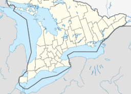 Location of the mouth of the Thames River in southern Ontario | |
The Thames River is located in southwestern Ontario, Canada.
The Thames flows west 273 kilometres (170 mi)[3] through southwestern Ontario, from the Town of Tavistock westward through the cities of Woodstock, London and Chatham to Lighthouse Cove on Lake St. Clair. Its drainage basin is 5,825 square kilometres (2,249 sq mi).[3]
Called Askunessippi (Anishinaabe language: Eshkani-ziibi, "the antlered river") by the Odawa and Ojibwa inhabitants, who together with the Neutrals have lived in the area since before Europeans arrived, the river was named after the River Thames in England by Lieutenant Governor John Graves Simcoe in 1793.
Much of the Thames is surrounded by deciduous Carolinian forests, although much of this forest has been removed to permit agriculture and other forms of development.
Course
There are three rivers in the watershed with Thames in the name—the Thames River itself, North Thames River, and Middle Thames River. These are also known locally as South Branch, North Branch, and Middle Branch. The South Branch is the main stem Thames River and officially carries the Thames River name.[5][6]
The Thames River and North Thames River on the upper part of the watershed flow through valleys created during the retreat of the glaciers during the last ice age. The Thames River and North Thames River meet in central London at the "Forks"; the University of Western Ontario is located north of the Forks at the north branch's confluence with Medway Creek. The Middle Thames River runs north of the Thames River joining it west of Ingersoll. Downriver from London, the lower part of the river flows through a shallow plain of sand and clay, with an average depth of 4 feet (1.2 m). The lower Thames River flows through Delaware, Chatham, Thamesville, as well as Chippewa and Oneida First Nations settlements. Tributaries of the Thames include the Avon River, Dingman Creek, Jeanettes Creek, McGregor Creek, Medway Creek, Pottersburg Creek, Stoney Creek, Trout Creek and Waubuno Creek.
Three separate dams are used to control seasonal flooding in the watershed: Wildwood Dam, located on Trout Creek which flows into the North Thames River; Pittock Dam, located on the Thames River near Woodstock; and the Fanshawe Dam located on the North Thames River in the northeasterly area of London. A fourth dam at Springbank Park, downstream from the Forks, controlled water levels in central London from the 1870s until 2005 when it was closed for rehabilitation. One of the Springbank Dam's gates failed in 2008, causing the dam to be locked in the open position, and rehabilitation was delayed pending litigation between an engineering firm and the City of London.[7] On January 9, 2018, London's civic works committee voted to decommission the Springbank Dam permanently.[8]
History
The river was the location of an important battle of the War of 1812. The Battle of the Thames (also known as the Battle of Moraviantown) was fought on October 5, 1813, between American General William Henry Harrison and British General Henry Proctor, along with Proctor's ally Tecumseh. Chief Tecumseh was killed in the battle.
On May 25, 1881, the river steamer 'Victoria' capsized and sank killing 182 passengers. After the disaster all ferries could only carry their maximum capacity.
In the early morning hours of July 11, 1883, London flooded from heavy rainfall. The ferry "Princess Louise" was forced over Waterworks Dam and capsized killing 7.
On August 25, 1899, the propeller-boat "Thames" was set on fire and eventually sunk only feet from Waterworks Dam.
On April 27, 1937, the Thames River reached an all-time high of 21.5 feet (6.6 m) above normal flow resulting in 5 deaths and over 1000 homes being damaged.[9]
On August 13, 1950, a launch (boat) capsized and killed four passengers.
On August 14, 2000, the Thames River was designated a Canadian Heritage River.
During the weekend of February 24-25, 2018, abnormally persistent rains caused significant flooding along the banks of the river. Extensive property damage was observed in Chatham and nearby Thamesville.
References
- ↑ Google Earth elevation for GNIS coordinates
- ↑ "Thames River". Geographical Names Data Base. Natural Resources Canada.
- 1 2 3 4 "Thames River Fact Sheet". Canadian Heritage Rivers System. Archived from the original on 28 March 2010. Retrieved 13 October 2010.
- ↑ Station 02GE003 (Thames River at Thamesville), Archived Hydrometric Data Archived 2012-12-16 at Archive.is, Water Survey of Canada.
- ↑ Topographic maps via ACME Mapper
- ↑ Thames River Coordinating Committee (2000). "The Thames Strategy: Managing the Thames as a Canadian Heritage River" (PDF). Upper Thames River Conservation Authority. Retrieved 13 October 2010.
- ↑ "Springbank Dam". City of London. Retrieved August 14, 2018.
- ↑ Lamberink, Liny (January 9, 2018). "London's civic works committee says goodbye to the Springbank Dam". Global News. Retrieved August 14, 2018.
- ↑ "Twenty Five Years of Conservation on the Upper Thames Watershed, 1947-1973". UTRCA. Retrieved 2013-10-07.
External links
| Wikimedia Commons has media related to Thames River (Ontario). |
- Upper Thames River Conservation Authority
- Lower Thames Valley Conservation Authority
- City of London Web site
- Thames River, Natural Resources Canada, Geographical Names Board of Canada http://www4.rncan.gc.ca/search-place-names/unique/FCVOV
| Rivers |
|
|---|---|
| Nominated | |
| |