South Carolina Highway 61
| ||||
|---|---|---|---|---|
 | ||||
| Route information | ||||
| Maintained by SCDOT | ||||
| Length | 67.05 mi[1] (107.91 km) | |||
| Existed | 1923 – present | |||
| Tourist routes |
| |||
| Major junctions | ||||
| South end |
| |||
| ||||
| North end |
| |||
| Location | ||||
| Counties | Charleston, Dorchester, Colleton, Bamberg | |||
| Highway system | ||||
| ||||

South Carolina Highway 61 (SC 61) is a 67-mile-long (108 km) state highway in the U.S. state of South Carolina. The highway is designated on a north–south direction, but physically travels in an east–west direction, from SC 30 in Charleston to U.S. Route 78 (US 78) near Branchville. The portion of SC 61 from Church Creek Bridge and 10 miles (16 km) north is designated a National Scenic Byway.[2]
Route description
St. Andrew's Boulevard
The eastern-most section of SC 61 is named St. Andrew's Boulevard. This section travels from US 17 to SC 171. It is mostly residential buildings that have been rezoned commercial.
Ashley River Road
Ashley River Road is the portion of SC 61 that travels through Charleston near the Ashley River from SC 171 to SC 165. It is four lanes near Sam Rittenberg Boulevard, but becomes two lanes through the scenic stretch. Along the two-lane stretch, there are many large oaks and historic plantations. The SC 61/Ashley River Road exit from Interstate 526 (I-526) actually exits onto SC 461 (Paul Cantrell Boulevard).
Points of interest along Ashley River Road:
- Drayton Hall
- Magnolia Plantation and Gardens and the Audubon Swamp Garden
- Middleton Place Plantation
- Shadowmoss Plantation - Golf Club & Residential
- MacLaura Hall - Private Residential
Beech Hill Road
Beech Hill Road is the section of SC 61 that travels from SC 165 to US 17A. The Legend Oaks Plantation is south of this section of highway.
Augusta Highway
Augusta Highway is the longest section of SC 61 from US 17A to the westernmost end of SC 61 where it merges into US 78.
National Register of Historic Places
|
Ashley River Road | |
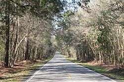 Ashley River Road 2.9 mi N of Bees Ferry Rd 2 | |
| Nearest city | Summerville, South Carolina |
|---|---|
| Area | 95 acres (38 ha) |
| Built | 1691 |
| Part of | Ashley River Historic District (#93001514) |
| NRHP reference # | 83003831[3] |
| Added to NRHP | November 21, 1983 |
Some or all of Ashley River Road was named to the National Register of Historic Places in 1983.[3][4][5] In 1993, it was included in the Ashley River Historic District.
Future
Developers continue to build more homes further and further down Ashley River Road. A great deal of controversy was created about overdevelopment when the City of North Charleston annexed the 6,600-acre tract known as Watson Hill. The tract was sold by MeadWestvaco to private developers who then requested the annexation by North Charleston. The town of Summerville tried to rush an annexation to block North Charleston which ended in a court battle. Summerville later rescinded and backed away from its annexation attempt. The slump in the economy, 2008-2010, forced these developers to sell and the property was repurchased by MeadWestvaco.[6][7]
A recent public meeting suggested that if development is to occur, instead of widening Ashley River Road to alleviate congestion, Glenn McConnell Parkway, also known as SC 461, could be extended beyond its terminus at Bees Ferry Road. This is possible since Glenn McConnell Parkway travels parallel to SC 61.
Major intersections
| County | Location | mi[1] | km | Destinations | Notes |
|---|---|---|---|---|---|
| Charleston | Charleston | 0.00– 0.21 | 0.00– 0.34 | Exit 1 (SC 30) | |
| 1.02– 1.07 | 1.64– 1.72 | Interchange; access from SC 61 to US 17 / from US 17 south to SC 61 north only | |||
| 1.07 | 1.72 | Southern end of SC 171 concurrency | |||
| 2.66– 2.75 | 4.28– 4.43 | Northern end of SC 171 concurrency | |||
| 4.08 | 6.57 | ||||
| 4.56– 4.65 | 7.34– 7.48 | Southern terminus of SC 461 | |||
| Dorchester | Cooke Crossroads | 19.47 | 31.33 | ||
| | 24.04 | 38.69 | Southern end of US 17 Alt. concurrency | ||
| | 24.45 | 39.35 | Northern end of US 17 Alt. concurrency | ||
| Givhans | 29.39 | 47.30 | Southern terminus of SC 27 | ||
| Colleton | | 39.71 | 63.91 | Northern terminus of SC 651 | |
| Canadys | 46.90 | 75.48 | |||
| | 49.59– 49.89 | 79.81– 80.29 | Exit 68 (I-95) | ||
| | 53.42 | 85.97 | Northern terminus of SC 217 | ||
| Bamberg | Whitestone Crossroads | 60.64 | 97.59 | ||
| | 66.84– 67.05 | 107.57– 107.91 | Access to / from US 78 east via unsigned US 78 Conn. | ||
1.000 mi = 1.609 km; 1.000 km = 0.621 mi
| |||||
References
- 1 2 "Statewide Highways (shapefile)" (zip). South Carolina Department of Transportation. September 29, 2017. Retrieved December 8, 2017.
- ↑ Bill Information - South Carolina Legislature Online
- 1 2 National Park Service (2010-07-09). "National Register Information System". National Register of Historic Places. National Park Service.
- ↑ Wylie, Suzanne Pickens; Norman McCorkle (August 23, 1983). "Ashley River Road" (pdf). National Register of Historic Places - Nomination and Inventory. Retrieved 9 June 2012.
- ↑ "Ashley River Road, Charleston County (S.C. Hwy. 61 btw. Church Creek & S.C. Hwy. 165, Charleston & Summerville vicinities, Charleston & Dorchester Counties)". National Register Properties in South Carolina. South Carolina Department of Archives and History. Retrieved 9 June 2012.
- ↑ "A hurrah for Watson Hill". Post and Courier.
- ↑ "Public weighs in on Watson Hill". Post and Courier.
External links

- CharlestonWiki Highway 61 article
- SC 61 South Carolina Hwy Index
| Topics |  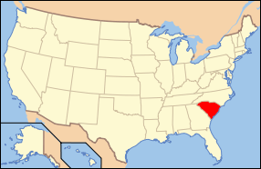 | |
|---|---|---|
| Lists by county |
| |
| Lists by city | ||
| Other lists | ||