Ashford, Alabama
| Ashford, Alabama | |
|---|---|
| Town | |
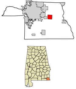 Location of Ashford in Houston County, Alabama. | |
| Coordinates: 31°11′2″N 85°14′7″W / 31.18389°N 85.23528°W | |
| Country | United States |
| State | Alabama |
| County | Houston |
| Area[1] | |
| • Total | 6.30 sq mi (16.33 km2) |
| • Land | 6.28 sq mi (16.27 km2) |
| • Water | 0.02 sq mi (0.06 km2) |
| Elevation | 279 ft (85 m) |
| Population (2010)[2] | |
| • Total | 2,148 |
| • Estimate (2017)[3] | 2,144 |
| • Density | 341.29/sq mi (131.78/km2) |
| Time zone | UTC-6 (Central (CST)) |
| • Summer (DST) | UTC-5 (CDT) |
| ZIP code | 36312 |
| Area code(s) | 334 |
| FIPS code | 01-02836 |
| GNIS feature ID | 0113251 |
Ashford is a town[4] in Houston County, Alabama, United States. It is part of the Dothan, Alabama Metropolitan Statistical Area. The town was incorporated in June 1891.[5] For most of its history, it was a center for naval stores production, pulpwood harvesting, and cotton agriculture. The population was 2,148 at the 2010 census,[6] up from 1,853 at the 2000 census.
Geography
Ashford is located slightly northeast of the center of Houston County at 31°11′3″N 85°14′7″W / 31.18417°N 85.23528°W (31.184032, -85.235286).[7] U.S. Route 84 passes through the southern part of the town, leading west 9 miles (14 km) to Dothan and southeast 24 miles (39 km) to Donalsonville, Georgia. The Chattahoochee River, which forms the Georgia state line, is 12 miles (19 km) southeast of Ashford on US 84.
According to the United States Census Bureau, the town has a total area of 6.3 square miles (16.4 km2), of which 0.02 square miles (0.06 km2), or 0.34%, are water.[6]
Government
Ashford's former mayor is Jonathon Grecu, he resigned from office on December 31, 2017. On January 8, 2018 Carole Barfield took office. As of October 2018, the current mayor is Carole Barfield, and City Council members are Gary Gibson, Ronnie Whitehead, Alan Anderson, James Smith, and Denise Herndon. The recreation director for the City of Ashford is Louis Edmondson. The City Clerk is Cassandra Lindenmuth.
The police chief is Quinton Vann, who supervises four full-time police officers; the fire chief is Jimmy Posey. The fire department and rescue squad are all volunteers.
The City of Ashford's website is http://cityofashford.com/
Education
Ashford has one elementary school for grades K-5 and a high school for grades 6-12. The schools mascot is known as the yellow jackets named Buzz. The current principle of Ashford Elementary School is Denise Kohen (https://www.hcboe.us/Domain/8) and the principle of Ashford High School is Bubba Odom (https://www.hcboe.us/Domain/9).
Ashford Academy was once a private school that closed its doors at the end of the 2014-2015 school year.
Recreation
The City of Ashford offers recreation activities through out the year, including baseball, softball, soccer, and basketball. The recreation director is Louis Edmondson and the grounds keeper is Steven Deese. The Ashford Recreation Sports Association (http://www.ashfordrec.org/site/) organizes and raises funds to support the programs. They are a nonprofit 501c3 organization and is a parent run organization dedicated to help operate the Ashford Recreation Department by raising funds and coordinating efforts of the department, coaches, parents and sponsors. Football and cheerleading is organized through the Ashford Youth Sports Association. Both organizations are nonprofit and are parent driven. The recreation ball fields are located behind Ashford High School on 8th Avenue. The recreation park includes 2 T-Ball fields, 2 softball fields and 2 baseball fields. Basketball is played at Ashford Elementary School. In 2015, Ashford hosted the 2015 Alabama State Class "A" Baseball Tournament.
Historical
In March 1888, the Alabama Midland Railway built a small depot of Victorian railroad architecture in Ashford to be a waystation along the Bainbridge-to-Montgomery route. The depot was the only building to survive the 1915 fire that destroyed the rest of the town. The original depot received additions at least twice—an enclosed warehouse and open loading dock were added to the east, followed by racially segregated passenger waiting rooms on the west side. The depot faced two sidings that served for loading turpentine from the Adams Company still one block away, and pulpwood. Cotton bales, fertilizer, and a single sweet potato crop were loaded from both sidings.
The depot changed hands as railroads consolidated. The Alabama Midland was absorbed by the Atlantic Coast Line, which merged in the 1980s with the Seaboard Air Line to form the Seaboard Coast Line. CSX Transportation later bought the Seaboard Coast Line. Ashford Depot had fallen into disrepair after it closed in 1978. In the 1980s, concerned citizens founded a preservation committee, led by Jimmy Burgess, and received a grant to add a new roof to the building. This committee also placed the depot on the Alabama Register of Historical Places. It remained active into the 1990s. Former Mayor Bryan Alloway revived the depot preservation committee after his 2000 election. This committee planned to incorporate and seek tax-exempt status in 2005. It received two US Department of Transportation grants ($850,000), two Alabama Department of Economic and Community Affairs grants ($290,000), and one Alabama Resource Conservation & Development (RC&D) grant ($7500) to thoroughly renovate the depot. Construction began in fall 2004. The committee and Ashford City officials held a ribbon-cutting ceremony on November 17, 2005, to mark the end of Phase I of the reconstruction. Now the depot can be used for reunions, birthdays, and social events that the city might sponsor.
On October 10, 2018, Hurricane Michael’s western eye wall passed thru the City of Ashford causing major damage and left 100% of the city with out power. No injuries or fatalities were associated with the storm.
Demographics
| Historical population | |||
|---|---|---|---|
| Census | Pop. | %± | |
| 1900 | 286 | — | |
| 1910 | 479 | 67.5% | |
| 1920 | 754 | 57.4% | |
| 1930 | 920 | 22.0% | |
| 1940 | 1,224 | 33.0% | |
| 1950 | 1,400 | 14.4% | |
| 1960 | 1,511 | 7.9% | |
| 1970 | 1,980 | 31.0% | |
| 1980 | 2,165 | 9.3% | |
| 1990 | 1,926 | −11.0% | |
| 2000 | 1,853 | −3.8% | |
| 2010 | 2,148 | 15.9% | |
| Est. 2017 | 2,144 | [3] | −0.2% |
| U.S. Decennial Census[8] 2013 Estimate[9] | |||
2000 Census data
As of the census[10] of 2000, there were 1,853 people, 763 households, and 527 families residing in the city. The population density was 303.9 people per square mile (117.3/km2). There were 877 housing units at an average density of 143.8 per square mile (55.5/km2). The racial makeup of the city was 71.45% White, 27.52% Black or African American, 0.70% Native American, 0.05% Asian, and 0.27% from two or more races. 1.51% of the population were Hispanic or Latino of any race.
There were 763 households out of which 30.1% had children under the age of 18 living with them, 52.3% were married couples living together, 14.0% had a female householder with no husband present, and 30.9% were non-families. 29.0% of all households were made up of individuals and 16.8% had someone living alone who was 65 years of age or older. The average household size was 2.43 and the average family size was 2.99.
In the city the population was spread out with 25.1% under the age of 18, 7.1% from 18 to 24, 26.2% from 25 to 44, 24.2% from 45 to 64, and 17.4% who were 65 years of age or older. The median age was 39 years. For every 100 females, there were 83.5 males. For every 100 females age 18 and over, there were 76.8 males.
The median income for a household in the city was $29,444, and the median income for a family was $40,313. Males had a median income of $30,167 versus $22,286 for females. The per capita income for the city was $15,135. About 11.3% of families and 16.9% of the population were below the poverty line, including 18.5% of those under age 18 and 27.7% of those age 65 or over.
2010 census
As of the census[2] of 2010, there were 2,148 people, 867 households, and 623 families residing in the city. The population density was 352.1 people per square mile (135.9/km2). There were 1,004 housing units at an average density of 164.6 per square mile (63.5/km2). The racial makeup of the city was 79.0% White, 19.5% Black or African American, 0.2% Native American, 0.2% Asian, and 0.7% from two or more races. .8% of the population were Hispanic or Latino of any race.
There were 867 households out of which 27.8% had children under the age of 18 living with them, 51.6% were married couples living together, 14.4% had a female householder with no husband present, and 28.1% were non-families. 24.8% of all households were made up of individuals and 13.3% had someone living alone who was 65 years of age or older. The average household size was 2.48 and the average family size was 2.94.
In the city the population was spread out with 23.7% under the age of 18, 9.0% from 18 to 24, 21.7% from 25 to 44, 28.2% from 45 to 64, and 17.4% who were 65 years of age or older. The median age was 41.2 years. For every 100 females, there were 91.1 males. For every 100 females age 18 and over, there were 94.0 males.
The median income for a household in the city was $35,709, and the median income for a family was $55,833. Males had a median income of $38,654 versus $27,143 for females. The per capita income for the city was $21,444. About 9.1% of families and 14.3% of the population were below the poverty line, including 21.5% of those under age 18 and 15.5% of those age 65 or over.
Notable person
- Robert Stewart, former Arena Football League player
References
- ↑ "2017 U.S. Gazetteer Files". United States Census Bureau. Retrieved Jul 7, 2018.
- 1 2 "American FactFinder". United States Census Bureau. Archived from the original on 2013-09-11. Retrieved 2015-07-25.
- 1 2 "Population and Housing Unit Estimates". Retrieved March 24, 2018.
- ↑ U.S. Census change list Archived August 6, 2010, at the Wayback Machine.
- ↑ http://www.encyclopediaofalabama.org/article/h-3073
- 1 2 "Geographic Identifiers: 2010 Demographic Profile Data (G001): Ashford town, Alabama". American Factfinder. U.S. Census Bureau. Retrieved April 12, 2017.
- ↑ "US Gazetteer files: 2010, 2000, and 1990". United States Census Bureau. 2011-02-12. Retrieved 2011-04-23.
- ↑ "U.S. Decennial Census". Census.gov. Archived from the original on May 12, 2015. Retrieved June 6, 2013.
- ↑ "Annual Estimates of the Resident Population: April 1, 2010 to July 1, 2013". Retrieved June 3, 2014.
- ↑ "American FactFinder". United States Census Bureau. Archived from the original on 2013-09-11. Retrieved 2008-01-31.
Coordinates: 31°11′03″N 85°14′07″W / 31.184032°N 85.235286°W
Municipalities and communities of Houston County, Alabama, United States | ||
|---|---|---|
| City | 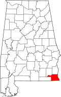 | |
| Towns | ||
| Unincorporated communities | ||
| Footnotes | ‡This populated place also has portions in an adjacent county or counties | |