Cottonwood, Alabama
| Cottonwood, Alabama | |
|---|---|
| Town | |
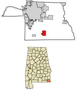 Location of Cottonwood in Houston County, Alabama. | |
| Coordinates: 31°3′13″N 85°18′8″W / 31.05361°N 85.30222°W | |
| Country | United States |
| State | Alabama |
| County | Houston |
| Area[1] | |
| • Total | 5.80 sq mi (15.02 km2) |
| • Land | 5.77 sq mi (14.95 km2) |
| • Water | 0.03 sq mi (0.07 km2) |
| Elevation | 164 ft (50 m) |
| Population (2010) | |
| • Total | 1,289 |
| • Estimate (2017)[2] | 1,256 |
| • Density | 217.56/sq mi (84.01/km2) |
| Time zone | UTC-6 (Central (CST)) |
| • Summer (DST) | UTC-5 (CDT) |
| ZIP code | 36320 |
| Area code(s) | 334 |
| FIPS code | 01-17824 |
| GNIS feature ID | 0116695 |
| Website |
www |
Cottonwood is a town in Houston County, Alabama, United States. One source said the town incorporated in 1901,[3] although the 1910 U.S. Census stated 1903. It is part of the Dothan, Alabama Metropolitan Statistical Area. At the 2010 census the population was 1,289,[4] up from 1,170 in 2000.
Geography
Cottonwood is located in southern Houston County at 31°3′13″N 85°18′9″W / 31.05361°N 85.30250°W (31.053646, -85.302409).[5] Alabama State Route 53 passes through the center of town, leading north 14 miles (23 km) to Dothan and southeast 7 miles (11 km) to the Florida state line. Malone, Florida, is 11 miles (18 km) southeast of Cottonwood.
According to the U.S. Census Bureau, the town has a total area of 5.8 square miles (15.0 km2), of which 0.03 square miles (0.07 km2), or 0.45%, are water.[4]
Demographics
| Historical population | |||
|---|---|---|---|
| Census | Pop. | %± | |
| 1910 | 352 | — | |
| 1920 | 293 | −16.8% | |
| 1930 | 410 | 39.9% | |
| 1940 | 600 | 46.3% | |
| 1950 | 864 | 44.0% | |
| 1960 | 953 | 10.3% | |
| 1970 | 1,149 | 20.6% | |
| 1980 | 1,352 | 17.7% | |
| 1990 | 1,385 | 2.4% | |
| 2000 | 1,170 | −15.5% | |
| 2010 | 1,289 | 10.2% | |
| Est. 2017 | 1,256 | [2] | −2.6% |
| U.S. Decennial Census[6] 2013 Estimate[7] | |||
As of the census[8] of 2000, there were 1,170 people, 485 households, and 323 families residing in the town. The population density was 212.9 people per square mile (82.1/km2). There were 548 housing units at an average density of 99.7 per square mile (38.5/km2). The racial makeup of the town was 69.06% White, 29.06% Black or African American, 0.68% Native American, and 1.20% from two or more races. 1.97% of the population were Hispanic or Latino of any race.
There were 485 households out of which 29.3% had children under the age of 18 living with them, 48.2% were married couples living together, 14.2% had a female householder with no husband present, and 33.2% were non-families. 30.5% of all households were made up of individuals and 15.5% had someone living alone who was 65 years of age or older. The average household size was 2.41 and the average family size was 3.01.
In the town, the population was spread out with 26.5% under the age of 18, 7.1% from 18 to 24, 25.0% from 25 to 44, 24.5% from 45 to 64, and 16.9% who were 65 years of age or older. The median age was 38 years. For every 100 females, there were 90.6 males. For every 100 females age 18 and over, there were 86.1 males.
The median income for a household in the town was $21,452, and the median income for a family was $32,065. Males had a median income of $25,833 versus $15,515 for females. The per capita income for the town was $13,111. About 18.1% of families and 27.2% of the population were below the poverty line, including 28.8% of those under age 18 and 42.1% of those age 65 or over.
2010 census
As of the census[9] of 2010, there were 1,289 people, 553 households, and 350 families residing in the town. The population density was 234.4 people per square mile (90.8/km2). There were 638 housing units at an average density of 116 per square mile (44.9/km2). The racial makeup of the town was 71.8% White, 25.4% Black or African American, 0.6% Native American, and 1.9% from two or more races. 1.1% of the population were Hispanic or Latino of any race.
There were 553 households out of which 24.4% had children under the age of 18 living with them, 42.0% were married couples living together, 16.1% had a female householder with no husband present, and 36.7% were non-families. 33.5% of all households were made up of individuals and 13.9% had someone living alone who was 65 years of age or older. The average household size was 2.33 and the average family size was 2.99.
In the town, the population was spread out with 22.5% under the age of 18, 9.2% from 18 to 24, 22.2% from 25 to 44, 29.2% from 45 to 64, and 16.9% who were 65 years of age or older. The median age was 42.4 years. For every 100 females, there were 87.9 males. For every 100 females age 18 and over, there were 86.4 males.
The median income for a household in the town was $26,570, and the median income for a family was $27,465. Males had a median income of $28,942 versus $27,857 for females. The per capita income for the town was $15,090. About 26.1% of families and 28.0% of the population were below the poverty line, including 38.5% of those under age 18 and 13.5% of those age 65 or over.
Notable people
- Pete Coachman, former Major League Baseball player (California Angels)
- Emmett Ripley Cox, Senior Judge of the United States Court of Appeals for the Eleventh Circuit
- Lamar Kelly, World War II hero, decorated numerous times for action in both the Pacific and Atlantic theaters while serving in the United States Navy. Kelly also fought his way to the title of Severn River Naval Command Welterweight Boxing Champion and later United States Golden Gloves Welterweight Champion. Years later, he garnered acclaim as one of the nation's most innovative drug store retailers.
- Curtis McGriff, former defensive lineman for the New York Giants of the National Football League
- Katherine Reid, born in Cottonwood in about 1901, performed stage shows as the Lady Alligator Wrestler in the 1930s before retiring. But in 1968, at age 67, she came out of retirement to appear on Rowan and Martin's Laugh-In.[10]
References
- ↑ "2017 U.S. Gazetteer Files". United States Census Bureau. Retrieved Jul 7, 2018.
- 1 2 "Population and Housing Unit Estimates". Retrieved March 24, 2018.
- ↑ http://www.encyclopediaofalabama.org/article/h-3344
- 1 2 "Geographic Identifiers: 2010 Demographic Profile Data (G001): Cottonwood town, Alabama". American Factfinder. U.S. Census Bureau. Retrieved April 12, 2017.
- ↑ "US Gazetteer files: 2010, 2000, and 1990". United States Census Bureau. 2011-02-12. Retrieved 2011-04-23.
- ↑ "U.S. Decennial Census". Census.gov. Archived from the original on 12 May 2015. Retrieved June 6, 2013.
- ↑ "Annual Estimates of the Resident Population: April 1, 2010 to July 1, 2013". Retrieved June 3, 2014.
- ↑ "American FactFinder". United States Census Bureau. Archived from the original on 11 September 2013. Retrieved 2008-01-31.
- ↑ "American FactFinder". United States Census Bureau. Archived from the original on 11 September 2013. Retrieved 2015-07-25.
- ↑ "The Shields Giants of Alabama, Lady Alligator Wrestler and other circus and sideshow tales". AL.com.
External links
Coordinates: 31°03′13″N 85°18′09″W / 31.053646°N 85.302409°W
Municipalities and communities of Houston County, Alabama, United States | ||
|---|---|---|
| City |  | |
| Towns | ||
| Unincorporated communities | ||
| Footnotes | ‡This populated place also has portions in an adjacent county or counties | |