Kinsey, Alabama
| Kinsey, Alabama | |
|---|---|
| Town | |
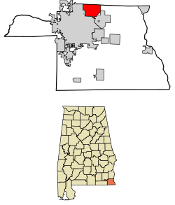 Location of Kinsey in Houston County, Alabama. | |
| Coordinates: 31°17′30″N 85°20′44″W / 31.29167°N 85.34556°W | |
| Country | United States |
| State | Alabama |
| County | Houston |
| Area[1] | |
| • Total | 12.10 sq mi (31.33 km2) |
| • Land | 12.10 sq mi (31.33 km2) |
| • Water | 0.00 sq mi (0.00 km2) |
| Elevation | 328 ft (100 m) |
| Population (2010) | |
| • Total | 2,198 |
| • Estimate (2017)[2] | 2,185 |
| • Density | 180.64/sq mi (69.74/km2) |
| Time zone | UTC-6 (Central (CST)) |
| • Summer (DST) | UTC-5 (CDT) |
| ZIP code | 36303 |
| Area code(s) | 334 |
| FIPS code | 01-40072 |
| GNIS feature ID | 0121244 |
Kinsey is a town in Houston County, Alabama, United States. It was initially located and incorporated in Henry County in February 1893.[3] In 1903, it was redrawn into newly created Houston County and was later reincorporated in August 1957.[4] It is part of the Dothan, Alabama Metropolitan Statistical Area. At the 2010 census the population was 2,198,[5] up from 1,796 in 2000.
History
Kinsey was named for an early postmaster, Eliza Kinsey.[6]
Geography
Kinsey is located in northern Houston County at 31°17′30″N 85°20′44″W / 31.29167°N 85.34556°W (31.291688, -85.345487).[7] It is bordered to the south and west by the city of Dothan, to the southeast by the town of Webb, and to the north by the city of Headland in Henry County.
U.S. Route 431 passes through the western part of Kinsey, leading north 21 miles (34 km) to Abbeville and southwest 7 miles (11 km) to Dothan.
According to the U.S. Census Bureau, Kinsey has a total area of 12.1 square miles (31.3 km2), all land.[5]
Demographics
| Historical population | |||
|---|---|---|---|
| Census | Pop. | %± | |
| 1900 | 342 | — | |
| 1910 | 340 | −0.6% | |
| 1960 | 283 | — | |
| 1970 | 219 | −22.6% | |
| 1980 | 1,239 | 465.8% | |
| 1990 | 1,679 | 35.5% | |
| 2000 | 1,796 | 7.0% | |
| 2010 | 2,198 | 22.4% | |
| Est. 2017 | 2,185 | [2] | −0.6% |
| U.S. Decennial Census[8] 2013 Estimate[9] | |||
As of the census[10] of 2000, there were 1,796 people, 687 households, and 509 families residing in the town. The population density was 148.4 people per square mile (57.3/km²). There were 768 housing units at an average density of 63.5 per square mile (24.5/km²). The racial makeup of the town was 58.07% White, 40.48% Black or African American, 0.33% Asian, 0.06% Pacific Islander, 0.56% from other races, and 0.50% from two or more races. 1.22% of the population were Hispanic or Latino of any race.
There were 687 households out of which 42.6% had children under the age of 18 living with them, 50.8% were married couples living together, 19.4% had a female householder with no husband present, and 25.8% were non-families. 22.9% of all households were made up of individuals and 7.4% had someone living alone who was 65 years of age or older. The average household size was 2.61 and the average family size was 3.07.
In the town, the population was spread out with 32.2% under the age of 18, 8.6% from 18 to 24, 32.3% from 25 to 44, 18.0% from 45 to 64, and 8.8% who were 65 years of age or older. The median age was 31 years. For every 100 females, there were 86.9 males. For every 100 females age 18 and over, there were 83.3 males.
The median income for a household in the town was $27,578, and the median income for a family was $33,950. Males had a median income of $25,669 versus $20,227 for females. The per capita income for the town was $14,196. About 20.3% of families and 21.3% of the population were below the poverty line, including 29.0% of those under age 18 and 17.8% of those age 65 or over.
2010 census
As of the census[11] of 2010, there were 2,198 people, 810 households, and 598 families residing in the town. The population density was 181.7 people per square mile (70.2/km²). There were 899 housing units at an average density of 74.3 per square mile (28.9/km²). The racial makeup of the town was 49.9% White, 46.0% Black or African American, 0.1% Asian, 0.0% Pacific Islander, 2.1% from other races, and 1.5% from two or more races. 4.0% of the population were Hispanic or Latino of any race.
There were 810 households out of which 37.5% had children under the age of 18 living with them, 46.8% were married couples living together, 21.7% had a female householder with no husband present, and 26.2% were non-families. 22.8% of all households were made up of individuals and 6.0% had someone living alone who was 65 years of age or older. The average household size was 2.71 and the average family size was 3.18.
In the town, the population was spread out with 30.2% under the age of 18, 9.1% from 18 to 24, 28.5% from 25 to 44, 22.6% from 45 to 64, and 9.7% who were 65 years of age or older. The median age was 32.4 years. For every 100 females, there were 95.0 males. For every 100 females age 18 and over, there were 89.4 males.
The median income for a household in the town was $33,516, and the median income for a family was $34,643. Males had a median income of $29,429 versus $22,339 for females. The per capita income for the town was $17,145. About 20.3% of families and 23.3% of the population were below the poverty line, including 40.2% of those under age 18 and 10.7% of those age 65 or over.
References
- ↑ "2017 U.S. Gazetteer Files". United States Census Bureau. Retrieved Jul 7, 2018.
- 1 2 "Population and Housing Unit Estimates". Retrieved March 24, 2018.
- ↑ https://books.google.com/books?id=Y5A3AAAAIAAJ&pg=PA1244&lpg=PA1244&dq=%22kinsey%22+%22henry+county%22+%22alabama%22+%22incorporated%22&source=bl&ots=uCT_Nxz6Z8&sig=-i9v7Nd6QfNpMYMlp0Ww7wOioKs&hl=en&sa=X&ved=0ahUKEwjSo93sgcnKAhXBSyYKHXHIAvg4ChDoAQgdMAA#v=onepage&q=%22kinsey%22%20%22henry%20county%22%20%22alabama%22%20%22incorporated%22&f=false
- ↑ http://www.encyclopediaofalabama.org/article/h-3603
- 1 2 "Geographic Identifiers: 2010 Demographic Profile Data (G001): Kinsey town, Alabama". American Factfinder. U.S. Census Bureau. Retrieved April 13, 2017.
- ↑ "Profile for Kinsey, AL". ePodunk. Retrieved 6 April 2014.
- ↑ "US Gazetteer files: 2010, 2000, and 1990". United States Census Bureau. 2011-02-12. Retrieved 2011-04-23.
- ↑ "U.S. Decennial Census". Census.gov. Archived from the original on May 12, 2015. Retrieved June 6, 2013.
- ↑ "Annual Estimates of the Resident Population: April 1, 2010 to July 1, 2013". Archived from the original on May 22, 2014. Retrieved June 3, 2014.
- ↑ "American FactFinder". United States Census Bureau. Retrieved 2008-01-31.
- ↑ "American FactFinder". United States Census Bureau. Retrieved 2015-07-25.
Municipalities and communities of Houston County, Alabama, United States | ||
|---|---|---|
| City | 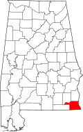 | |
| Towns | ||
| Unincorporated communities | ||
| Footnotes | ‡This populated place also has portions in an adjacent county or counties | |