Arrondissement of Boulay-Moselle
| Boulay-Moselle | |
|---|---|
| Arrondissement | |
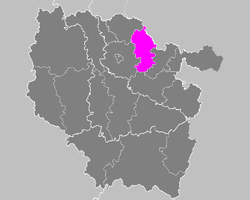 Location of Boulay-Moselle in Lorraine | |
| Country | France |
| Region | Lorraine |
| Department | Moselle |
| Cantons | 3 |
| Communes | 96 |
| Subprefecture | Boulay-Moselle |
| Area¹ | |
| • Total | 722 km2 (279 sq mi) |
| Population (1999) | |
| • Total | 74,628 |
| • Density | 100/km2 (270/sq mi) |
| ¹ French Land Register data, which exclude lakes, ponds, and glaciers larger than 1 km² as well as the estuaries of rivers. | |
The arrondissement of Boulay-Moselle is a former arrondissement of France in the Moselle department in the Lorraine region. In 2015 it was merged into the new arrondissement of Forbach-Boulay-Moselle.[1] It had three cantons and 96 communes.
Composition
Cantons
The cantons of the arrondissement of Boulay-Moselle were:
Communes
The communes of the arrondissement of Boulay-Moselle, and their INSEE codes, were:
| 1. Adaincourt (57007) | 2. Adelange (57008) | 3. Alzing (57016) |
| 4. Anzeling (57025) | 5. Arraincourt (57027) | 6. Arriance (57029) |
| 7. Bambiderstroff (57047) | 8. Bannay (57048) | 9. Berviller-en-Moselle (57069) |
| 10. Bettange (57070) | 11. Bibiche (57079) | 12. Bionville-sur-Nied (57085) |
| 13. Bisten-en-Lorraine (57087) | 14. Boucheporn (57095) | 15. Boulay-Moselle (57097) |
| 16. Bouzonville (57106) | 17. Brettnach (57110) | 18. Brouck (57112) |
| 19. Château-Rouge (57131) | 20. Chémery-les-Deux (57136) | 21. Colmen (57149) |
| 22. Condé-Northen (57150) | 23. Coume (57154) | 24. Creutzwald (57160) |
| 25. Créhange (57159) | 26. Dalem (57165) | 27. Dalstein (57167) |
| 28. Denting (57172) | 29. Elvange (57190) | 30. Falck (57205) |
| 31. Faulquemont (57209) | 32. Filstroff (57213) | 33. Flétrange (57217) |
| 34. Fouligny (57230) | 35. Freistroff (57235) | 36. Gomelange (57252) |
| 37. Guerstling (57273) | 38. Guerting (57274) | 39. Guinglange (57276) |
| 40. Guinkirchen (57277) | 41. Hallering (57284) | 42. Ham-sous-Varsberg (57288) |
| 43. Han-sur-Nied (57293) | 44. Hargarten-aux-Mines (57296) | 45. Haute-Vigneulles (57714) |
| 46. Heining-lès-Bouzonville (57309) | 47. Helstroff (57312) | 48. Herny (57319) |
| 49. Hestroff (57322) | 50. Hinckange (57326) | 51. Holacourt (57328) |
| 52. Holling (57329) | 53. Hémilly (57313) | 54. Laudrefang (57386) |
| 55. Longeville-lès-Saint-Avold (57413) | 56. Mainvillers (57430) | 57. Many (57442) |
| 58. Marange-Zondrange (57444) | 59. Menskirch (57457) | 60. Merten (57460) |
| 61. Momerstroff (57471) | 62. Mégange (57455) | 63. Narbéfontaine (57495) |
| 64. Neunkirchen-lès-Bouzonville (57502) | 65. Niedervisse (57507) | 66. Oberdorff (57516) |
| 67. Obervisse (57519) | 68. Ottonville (57530) | 69. Piblange (57542) |
| 70. Pontpierre (57549) | 71. Roupeldange (57599) | 72. Rémelfang (57567) |
| 73. Rémering (57570) | 74. Saint-François-Lacroix (57610) | 75. Schwerdorff (57640) |
| 76. Teting-sur-Nied (57668) | 77. Thicourt (57670) | 78. Thonville (57673) |
| 79. Tritteling-Redlach (57679) | 80. Tromborn (57681) | 81. Téterchen (57667) |
| 82. Vahl-lès-Faulquemont (57686) | 83. Valmunster (57691) | 84. Varize (57695) |
| 85. Varsberg (57696) | 86. Vatimont (57698) | 87. Vaudreching (57700) |
| 88. Velving (57705) | 89. Villing (57720) | 90. Vittoncourt (57726) |
| 91. Vœlfling-lès-Bouzonville (57749) | 92. Voimhaut (57728) | 93. Volmerange-lès-Boulay (57730) |
| 94. Zimming (57762) | 95. Ébersviller (57186) | 96. Éblange (57187) |
References
External links
This article is issued from
Wikipedia.
The text is licensed under Creative Commons - Attribution - Sharealike.
Additional terms may apply for the media files.