Arminto, Wyoming
| Arminto, Wyoming | |
|---|---|
| Unincorporated community | |
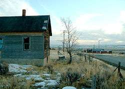 South view of Arminto, Wyoming | |
 Arminto, Wyoming Location within the state of Wyoming  Arminto, Wyoming Arminto, Wyoming (the US) | |
| Coordinates: 43°10′44″N 107°15′27″W / 43.17889°N 107.25750°WCoordinates: 43°10′44″N 107°15′27″W / 43.17889°N 107.25750°W | |
| Country | United States |
| State | Wyoming |
| County | Natrona |
| Elevation | 6,053 ft (1,845 m) |
| Population (2000) | |
| • Total | 5 |
| Time zone | UTC-7 (Mountain (MST)) |
| • Summer (DST) | UTC-6 (MDT) |
| GNIS feature ID | 1584934[1] |
Arminto is an unincorporated community in northwestern Natrona County, Wyoming, United States. It lies along local roads west of the city of Casper, the county seat of Natrona County.[2] Its elevation is 6,053 feet (1,845 m).[1] Although Arminto is unincorporated, it had a post office, that closed in 1964.[3]
Climate
According to the Köppen Climate Classification system, Arminto has a semi-arid climate, abbreviated "BSk" on climate maps.[4]
References
- 1 2 "Arminto, Wyoming". Geographic Names Information System. United States Geological Survey.
- ↑ Rand McNally. The Road Atlas '08. Chicago: Rand McNally, 2008, p. 116.
- ↑ http://about.usps.com/who-we-are/postmasterfinder/welcome.htm
- ↑ Climate Summary for Arminto, Wyoming
Municipalities and communities of Natrona County, Wyoming, United States | ||
|---|---|---|
| City | 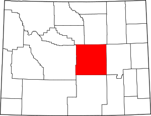 | |
| Towns | ||
| CDPs | ||
| Unincorporated communities | ||
This article is issued from
Wikipedia.
The text is licensed under Creative Commons - Attribution - Sharealike.
Additional terms may apply for the media files.