Arizona, Manitoba
| Arizona | |
|---|---|
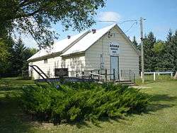 Arizona Community Hall | |
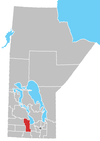
 Arizona Location of Arizona in Manitoba | |
| Coordinates: 49°49′42″N 99°1′40″W / 49.82833°N 99.02778°WCoordinates: 49°49′42″N 99°1′40″W / 49.82833°N 99.02778°W | |
| Country |
|
| Province |
|
| Region | Central Plains |
| Census Division | No. 8 |
| Government | |
| • Governing Body | Rural Municipality of North Norfolk Council |
| • MP | Candice Bergen |
| • MLA | Stu Briese |
| Time zone | UTC−6 (CST) |
| • Summer (DST) | UTC−5 (CDT) |
| Area code(s) | 204, 431 |
| NTS Map | 062G14 |
| GNBC Code | GAAZJ |
Arizona is a locality in the Rural Municipality of North Norfolk in south central Manitoba, Canada. It is located approximately 66 kilometers (41 miles) east of Brandon, Manitoba,[1] about 377m above sea level in an area which experiences frequent drought.[2]
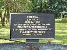
A post office operated under this name from 1892 to 1904 on 9-10-12W. There was also a school district. The school, located on SE 16-10-12W, was first a log building constructed in 1888, and later a brick building in 1921. Another building was brought from another municipality in 1963. Arizona school was closed in 1968.[3]
In 1898 a Presbyterian Church was built in Arizona. This church was later used by Methodists and later became part of the United Church of Canada. In 1974 money was raised to have the building moved to the Manitoba Agricultural Museum.[4]
Arizona also has a community hall that was built in 1901.[3]
References
- Geographic Names of Manitoba - Arizona pg. 11 : published by the Millennium Bureau of Canada
- ↑ "Geographical Names of Canada - Querying Distances". nrcan.gc.ca. 2011-10-24. Archived from the original on 2014-04-16. Retrieved 2013-01-12.
- ↑ Arizona (populated locality), Chinci World Atlas
- 1 2 Historic Sites of Manitoba: Arizona School No. 478 (1886-1968), The Historical Society of Manitoba
- ↑ Arizona Church – 1898, Manitoba Agricultural Museum
Division No. 8, Manitoba (Central Manitoba) | ||||
|---|---|---|---|---|
| Towns |
|  | ||
| Villages |
| |||
| Rural municipalities |
| |||
| First Nations | ||||
| Indian reserves |
| |||
| Unincorporated communities | ||||