Arani Province
| Arani | |
|---|---|
| Province | |
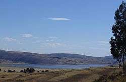 Parqu Qucha, one of the lakes of the Vacas Municipality | |
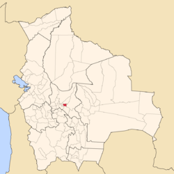 Location of the Arani Province within Bolivia | |
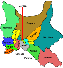 Provinces of the Cochabamba Department | |
| Coordinates: 17°37′S 66°05′W / 17.617°S 66.083°W | |
| Country |
|
| Department | Cochabamba Department |
| Municipalities | 2 |
| Cantons | 4 |
| Foundation | November 24, 1914 |
| Capital | Arani |
| Area | |
| • Total | 867 sq mi (2,245 km2) |
| Population (2001) | |
| • Total | 24,053 |
| • Density | 123.1/sq mi (47.54/km2) |
| • Ethnicities | Quechua |
| Area code(s) | BO.CB.AR |
Arani is a province in Cochabamba Department, Bolivia. Its capital is Arani, situated about 53 km from Cochabamba. Arani is known for its bread but also for the town's artisan wickerwork.
Geography
Some of the highest mountains of the province are listed below:[1][2]
- Chawpi Urqu
- Chullpa Ch'utu
- Ikma Mayu
- Inka P'iqi
- Iskay Wasi
- Jatun Llallawa
- Jatun Punta Mayuq
- Jatun Salla
- Juch'uy Llallawa
- Kuntur
- K'illi K'illi
- Llusk'a Llusk'a
- Mayu Urqu
- Murun Pampa
- Ñuñu Urqu
- Puka Chanka
- Pukara
- Phaqcha Urqu
- Qucha Quchayuq Urqu
- Qullpa Qucha Urqu
- Qullu Mayu
- Qutu Rumi
- Q'illu Q'asa
- Salla Punta
- Salla Q'asa
- Siqina Urqu
- T'utura Pampa
- Urqu Punta
- Wanu Wanu
- Waylla Qucha
- Yana Qucha
Subdivision
The province is divided into two municipalities which are further subdivided into four cantons.
| Section | Municipality | Inhabitants [3] | Seat | Inhabitants [4] |
|---|---|---|---|---|
| 1st | Arani | 11,542 | Arani | 3,512 |
| 2nd | Vacas | 12,511 | Vacas | 650 |
Arani Municipality consists of three cantons, Arani, Pocoata and Collpaciaco. Vacas Municipality is not further subdivided, so Vacas Canton and Vacas Municipality are identical.
Population
The people in the Arani Province are mainly indigenous citizens of Quechua descent.[5]
| Ethnic group | Arani Municipality | Vacas Municipality |
|---|---|---|
| Quechua | 87.2 | 94.4 |
| Aymara | 0.4 | 0.2 |
| Guaraní, Chiquitos, Moxos | 0.2 | 0.0 |
| Not indigenous | 12.1 | 5.4 |
| Other indigenous groups | 0.1 | 0.1 |
Languages
The languages spoken in the Arani Province are mainly Quechua and Spanish. The following table shows the number of those belonging to the recognized group of speakers.[5]
| Language | Arani Municipality | Vacas Municipality |
|---|---|---|
| Quechua | 10,347 | 11,662 |
| Aymara | 76 | 39 |
| Guaraní | 5 | 2 |
| Another native | 5 | 2 |
| Spanish | 7,082 | 4,236 |
| Foreign | 49 | 11 |
| Only native | 3,902 | 7,540 |
| Native and Spanish | 6,467 | 4,131 |
| Only Spanish | 615 | 106 |
Tourism
Festivals and Fairs:
- August 14–15: Saint Isidore the Laborer in Qullpayaku, 2 days
- August 24–25: Virgen la Bella in Arani, 2 days
- September 20: Farmers' fair in Tacopaya, 1 day
- 3rd week in November: Bread fair in Arani, 1 day
- December 4: Saint Barbara in Vacas
Other tourist attractions include the church of Saint Bartholomew (San Bartolomé) in Arani, built in 1610, which is dedicated to the Virgen la Bella, and the lakes in Vacas Municipality: Parqu Qucha, Asiru Qucha, Junt'utuyu, Pilawit'u, Qullpa Qucha and Yanatama.
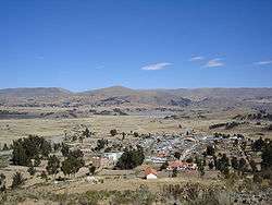
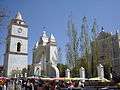 San Bartolomé church in Arani which keeps the shrine of the Virgen La Bella
 The giant Puya raimondi plants grow on Khurupampa mountain in the Vacas Municipality.
See also
References
- ↑ Bolivian IGM map 1:50,000 Vacas 6441-II
- ↑ "Vacas". INE, Bolivia. Archived from the original on March 4, 2016. Retrieved March 4, 2016.
- ↑ www.ine.gov.bo Archived August 25, 2007, at the Wayback Machine.
- ↑ "world-gazetteer.com". Archived from the original on 2008-10-24.
- 1 2 obd.descentralizacion.gov.bo/municipal/fichas/ (inactive)
External links
| Wikimedia Commons has media related to Arani Province. |
Capital: Cochabamba | ||
| Provinces | | |
| Municipalities (and seats) |
| |