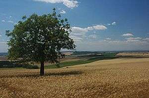
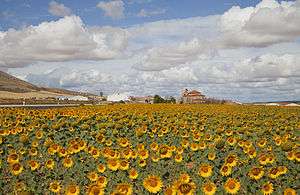
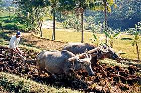
Arable land
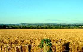
Arable land (from Latin arabilis, "able to be plowed") is, according to one definition, land capable of being ploughed and used to grow crops.[1] In Britain, it was traditionally contrasted with pasturable land such as heaths which could be used for sheep-rearing but not farmland.
A quite different kind of definition is used by various agencies concerned with agriculture. In providing statistics on arable land, the FAO and the World Bank[2] use the definition offered in the glossary accompanying FAOSTAT: "Arable land is the land under temporary agricultural crops (multiple-cropped areas are counted only once), temporary meadows for mowing or pasture, land under market and kitchen gardens and land temporarily fallow (less than five years). The abandoned land resulting from shifting cultivation is not included in this category. Data for ‘Arable land’ are not meant to indicate the amount of land that is potentially cultivable."[3] A more concise definition appearing in the Eurostat glossary similarly refers to actual, rather than potential use: "land worked (ploughed or tilled) regularly, generally under a system of crop rotation."[4]
Cultivation of the land
Cultivation of the land is an important process to make land arable by loosening and tilling (breaking up) of the soil.[5]
Arable land area
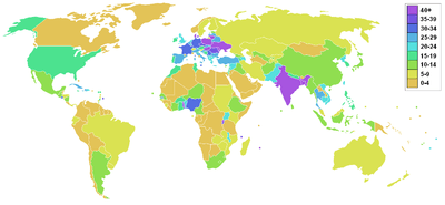
According to Food and Agriculture Organization of the United Nations the world's arable land amounted to 1,407 M ha, out of a total 4,924 M ha land used for agriculture, as for year 2013.[7]
|
Arable land (hectares per person)
| Country Name | 2013 |
|---|---|
| Afghanistan | 0.254 |
| Albania | 0.213 |
| Algeria | 0.196 |
| American Samoa | 0.054 |
| Andorra | 0.038 |
| Angola | 0.209 |
| Antigua and Barbuda | 0.044 |
| Argentina | 0.933 |
| Armenia | 0.150 |
| Aruba | 0.019 |
| Australia | 1.999 |
| Austria | 0.160 |
| Azerbaijan | 0.204 |
| Bahamas, The | 0.021 |
| Bahrain | 0.001 |
| Bangladesh | 0.049 |
| Barbados | 0.039 |
| Belarus | 0.589 |
| Belgium | 0.073 |
| Belize | 0.227 |
| Benin | 0.262 |
| Bermuda | 0.005 |
| Bhutan | 0.133 |
| Bolivia | 0.427 |
| Bosnia and Herzegovina | 0.264 |
| Botswana | 0.125 |
| Brazil | 0.372 |
| British Virgin Islands | 0.034 |
| Brunei Darussalam | 0.012 |
| Bulgaria | 0.479 |
| Burkina Faso | 0.363 |
| Burundi | 0.115 |
| Cabo Verde | 0.108 |
| Cambodia | 0.275 |
| Cameroon | 0.279 |
| Canada | 1.306 |
| Cayman Islands | 0.003 |
| Central African Republic | 0.382 |
| Chad | 0.373 |
| Channel Islands | 0.026 |
| Chile | 0.074 |
| China | 0.078 |
| Colombia | 0.036 |
| Comoros | 0.086 |
| Congo, Dem. Rep. | 0.098 |
| Congo, Rep. | 0.125 |
| Costa Rica | 0.049 |
| Côte d'Ivoire | 0.134 |
| Croatia | 0.206 |
| Cuba | 0.278 |
| Curaçao | |
| Cyprus | 0.070 |
| Czech Republic | 0.299 |
| Denmark | 0.429 |
| Djibouti | 0.002 |
| Dominica | 0.083 |
| Dominican Republic | 0.078 |
| Ecuador | 0.076 |
| Egypt, Arab Rep. | 0.031 |
| El Salvador | 0.120 |
| Equatorial Guinea | 0.151 |
| Eritrea | |
| Estonia | 0.480 |
| Ethiopia | 0.160 |
| Faroe Islands | 0.062 |
| Fiji | 0.187 |
| Finland | 0.409 |
| France | 0.277 |
| French Polynesia | 0.009 |
| Gabon | 0.197 |
| Gambia, The | 0.236 |
| Georgia | 0.119 |
| Germany | 0.145 |
| Ghana | 0.180 |
| Gibraltar | |
| Greece | 0.232 |
| Greenland | 0.016 |
| Grenada | 0.028 |
| Guam | 0.006 |
| Guatemala | 0.064 |
| Guinea | 0.259 |
| Guinea-Bissau | 0.171 |
| Guyana | 0.552 |
| Haiti | 0.103 |
| Honduras | 0.130 |
| Hong Kong SAR, China | 0.000 |
| Hungary | 0.445 |
| Iceland | 0.374 |
| India | 0.123 |
| Indonesia | 0.094 |
| Iran, Islamic Rep. | 0.193 |
| Iraq | 0.147 |
| Ireland | 0.242 |
| Isle of Man | 0.253 |
| Israel | 0.035 |
| Italy | 0.113 |
| Jamaica | 0.044 |
| Japan | 0.033 |
| Jordan | 0.032 |
| Kazakhstan | 1.726 |
| Kenya | 0.133 |
| Kiribati | 0.018 |
| Korea, Dem. People's Rep. | 0.094 |
| Korea, Rep. | 0.030 |
| Kosovo | |
| Kuwait | 0.003 |
| Kyrgyz Republic | 0.223 |
| Lao PDR | 0.226 |
| Latvia | 0.600 |
| Lebanon | 0.025 |
| Lesotho | 0.119 |
| Liberia | 0.116 |
| Libya | 0.274 |
| Liechtenstein | 0.070 |
| Lithuania | 0.774 |
| Luxembourg | 0.115 |
| Macao SAR, China | |
| Macedonia, FYR | 0.199 |
| Madagascar | 0.153 |
| Malawi | 0.235 |
| Malaysia | 0.032 |
| Maldives | 0.010 |
| Mali | 0.386 |
| Malta | 0.021 |
| Marshall Islands | 0.038 |
| Mauritania | 0.116 |
| Mauritius | 0.060 |
| Mexico | 0.186 |
| Micronesia, Fed. Sts. | 0.019 |
| Moldova | 0.510 |
| Monaco | |
| Mongolia | 0.198 |
| Montenegro | 0.013 |
| Morocco | 0.240 |
| Mozambique | 0.213 |
| Myanmar | 0.203 |
| Namibia | 0.341 |
| Nauru | |
| Nepal | 0.076 |
| Netherlands | 0.062 |
| New Caledonia | 0.024 |
| New Zealand | 0.123 |
| Nicaragua | 0.253 |
| Niger | 0.866 |
| Nigeria | 0.197 |
| Northern Mariana Islands | 0.019 |
| Norway | 0.159 |
| Oman | 0.010 |
| Pakistan | 0.168 |
| Palau | 0.048 |
| Panama | 0.148 |
| Papua New Guinea | 0.041 |
| Paraguay | 0.696 |
| Peru | 0.136 |
| Philippines | 0.057 |
| Poland | 0.284 |
| Portugal | 0.107 |
| Puerto Rico | 0.017 |
| Qatar | 0.007 |
| Romania | 0.438 |
| Russian Federation | 0.852 |
| Rwanda | 0.107 |
| Samoa | 0.042 |
| San Marino | 0.032 |
| São Tomé and Príncipe | 0.048 |
| Saudi Arabia | 0.102 |
| Senegal | 0.229 |
| Serbia | 0.460 |
| Seychelles | 0.001 |
| Sierra Leone | 0.256 |
| Singapore | 0.000 |
| Sint Maarten (Dutch part) | |
| Slovak Republic | 0.258 |
| Slovenia | 0.085 |
| Solomon Islands | 0.036 |
| Somalia | 0.107 |
| South Africa | 0.235 |
| South Sudan | |
| Spain | 0.270 |
| Sri Lanka | 0.063 |
| St. Kitts and Nevis | 0.092 |
| St. Lucia | 0.016 |
| St. Martin (French part) | |
| St. Vincent and the Grenadines | 0.046 |
| Sudan | 0.345 |
| Suriname | 0.112 |
| Swaziland | 0.140 |
| Sweden | 0.270 |
| Switzerland | 0.050 |
| Syrian Arab Republic | 0.241 |
| Tajikistan | 0.106 |
| Tanzania | 0.269 |
| Thailand | 0.249 |
| Timor-Leste | 0.131 |
| Togo | 0.382 |
| Tonga | 0.152 |
| Trinidad and Tobago | 0.019 |
| Tunisia | 0.262 |
| Turkey | 0.270 |
| Turkmenistan | 0.370 |
| Turks and Caicos Islands | 0.030 |
| Tuvalu | |
| Uganda | 0.189 |
| Ukraine | 0.715 |
| United Arab Emirates | 0.004 |
| United Kingdom | 0.098 |
| United States | 0.480 |
| Uruguay | 0.682 |
| Uzbekistan | 0.145 |
| Vanuatu | 0.079 |
| Venezuela, RB | 0.089 |
| Vietnam | 0.071 |
| Virgin Islands (U.S.) | 0.010 |
| West Bank and Gaza | 0.011 |
| Yemen, Rep. | 0.049 |
| Zambia | 0.243 |
| Zimbabwe | 0.268 |
Non-arable land
Agricultural land that is not arable according to the FAO definition above includes:
- Permanent crop – land that produces crops from woody vegetation, e.g. orchardland, vineyards, coffee plantations, rubber plantations, and land producing nut trees;
- Meadows and pastures – land used as pasture and grazed range, and those natural grasslands and sedge meadows that are used for hay production in some regions.
Other non-arable land includes land that is not suitable for any agricultural use.
Land that is not arable, in the sense of lacking capability or suitability for cultivation for crop production, has one or more limitations e.g. lack of sufficient fresh water for irrigation, stoniness, steepness, adverse climate, excessive wetness with impracticality of drainage, excessive salts, among others.[10] Although such limitations may preclude cultivation, and some will in some cases preclude any agricultural use, large areas unsuitable for cultivation are agriculturally productive. For example, US NRCS statistics indicate that about 59 percent of US non-federal pasture and unforested rangeland is unsuitable for cultivation, yet such land has value for grazing of livestock.[11] In British Columbia, Canada, 41 percent of the provincial Agricultural Land Reserve area is unsuitable for production of cultivated crops, but is suitable for uncultivated production of forage usable by grazing livestock.[12] Similar examples can be found in many rangeland areas elsewhere.
Land incapable of being cultivated for production of crops can sometimes be converted to arable land. New arable land makes more food, and can reduce starvation. This outcome also makes a country more self-sufficient and politically independent, because food importation is reduced. Making non-arable land arable often involves digging new irrigation canals and new wells, aqueducts, desalination plants, planting trees for shade in the desert, hydroponics, fertilizer, nitrogen fertilizer, pesticides, reverse osmosis water processors, PET film insulation or other insulation against heat and cold, digging ditches and hills for protection against the wind, and greenhouses with internal light and heat for protection against the cold outside and to provide light in cloudy areas. This process is often extremely expensive. An alternative is the Seawater Greenhouse which desalinates water through evaporation and condensation using solar energy as the only energy input. This technology is optimized to grow crops on desert land close to the sea.
(Note: The use of artifices does not make land arable. Rock, still remains rock, and shallow less than 6 feet turnable soil is still considered NONE toilable (IE: None arable). The use of artifice is an open air none recycled water hydroponics relationship. The below described circumstances are not in perspective, have limited duration, and have a tendency to accumulate trace materials in soil that either there or elsewhere cause de-oxination. IE: Use of fast amounts of fertilizer in the United States that end up devastating rivers, water ways and river endings due accumulation of none degradable toxins and Nitrogen bearing molecules that remove oxygen and cause none aerobic processes to form.)
Some examples of infertile non-arable land being turned into fertile arable land are:
- Aran Islands: These islands off the west coast of Ireland, (not to be confused with the Isle of Arran in Scotland's Firth of Clyde), were unsuitable for arable farming because they were too rocky. The people covered the islands with a shallow layer of seaweed and sand from the ocean. Today, crops are grown there, even though, the islands are still considered none arable.
- Israel: The construction of desalination plants along Israel's coast allowed agriculture in some areas that were formerly desert. The desalination plants, which remove the salt from ocean water, have created a new source of water for farming, drinking, and washing.
- Slash and burn agriculture uses nutrients in wood ash, but these expire within a few years.
- Terra preta, fertile tropical soils created by adding charcoal.
Some examples of fertile arable land being turned into infertile land are:
- Droughts like the 'dust bowl' of the Great Depression in the U.S. turned farmland into desert.
- Rainforest deforestation: The fertile tropical forests are converted into infertile desert land. For example, Madagascar's central highland plateau has become virtually totally barren (about ten percent of the country), as a result of slash-and-burn deforestation, an element of shifting cultivation practiced by many natives.
- Each year, arable land is lost due to desertification and human-induced erosion. Improper irrigation of farm land can wick the sodium, calcium, and magnesium from the soil and water to the surface. This process steadily concentrates salt in the root zone, decreasing productivity for crops that are not salt-tolerant.
See also
References
- ↑ Oxford English Dictionary, 3rd ed. "arable, adj. and n." Oxford University Press (Oxford), 2013.
- ↑ The World Bank. Agricultural land (% of land area) http://data.worldbank.org/indicator/AG.LND.AGRI.ZS Archived 17 May 2015 at the Wayback Machine.
- ↑ FAOSTAT. [Statistical database of the Food and Agriculture Organization of the United Nations] Glossary. http://faostat3.fao.org/mes/glossary/E Archived 1 June 2015 at the Wayback Machine.
- ↑ Eurostat. Glossary: Arable land. http://ec.europa.eu/eurostat/statistics-explained/index.php/Glossary:Arable_land Archived 7 May 2015 at the Wayback Machine.
- ↑ Cultivation Archived 20 April 2018 at the Wayback Machine.. Encyclopaedia Britannica.
- ↑ Arable land in this map refers to a definition used by the US CIA – land cultivated for crops like wheat, maize, and rice that are replanted after each harvest
- ↑ "FAOSTAT Land Use module". Food and Agriculture Organization. Archived from the original on 16 August 2016. Retrieved 8 July 2016.
- 1 2 "FAOSTAT Land Use module". Food and Agriculture Organization. Archived from the original on 16 August 2016. Retrieved 8 July 2016.
- ↑ "Arable Land Area". The Helgi Library. Archived from the original on 5 July 2014. Retrieved 22 February 2014.
- ↑ United States Department of Agriculture, Soil Conservation Service. 1961. Land capability classification. Agriculture Handbook 210. 21 pp.
- ↑ NRCS. 2013. Summary report 2010 national resources inventory. United States Natural Resources Conservation Service. 163 pp.
- ↑ Agricultural Land Commission. Agriculture Capability and the ALR Fact Sheet. http://www.alc.gov.bc.ca/alc/DownloadAsset?assetId=72876D8604EC45279B8D3C1B14428CF8&filename=agriculture_capability__the_alr_fact_sheet_2013.pdf
External links
- Surface area of the Earth
- Article from Technorati on Shrinking Arable Farmland in the world
| Air |
|  | ||||
|---|---|---|---|---|---|---|
| Energy | ||||||
| Land | ||||||
| Life | ||||||
| Water |
| |||||
| Related |
| |||||
| ||||||
| ||||||
| By location | |
|---|---|
| Types | |
| Sectors | |
| Law and regulation | |
| Economics, financing and valuation | |
| Parties | |
| Other |
|
| |