Ara (mountain)
| Ara | |
|---|---|
| Mount Ara | |
 | |
| Highest point | |
| Elevation | 2,614 m (8,576 ft) (other sources mention 2,576 m[1]) |
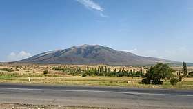
Mount Ara (Armenian: Արա լեռ, Ara leř) is a polygenetic stratovolcanic cone in Armenia's[2] Kotayk Province. The town of Zoravan and a nearby church, Gharghavank, are located along the mountain's lower slopes. The town of Yeghvard is below the mountain.
Located north of Yerevan, the mountain has a destroyed crater and a base diameter of 9km at an altitude of 1,900m. The volcano is constructed from lava and agglomerate layers with intrusions of andesite and dacite. The slopes on the north and east are forested. One flank cone south of Arailer has erupted andesite. Andesite also appears in the former crater and lava flows spread to the Hrazdan River. One K-Ar date indicates an age of 1.3 Ma, there are two subsidiary cones Nokhut and Shakhvard.[1]
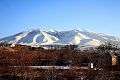
The mountain has a high biodiversity with Sympecma paedisca, Colias aurorina, Parnassius mnemosyne rjabovi, Armenohelops armeniacus, Cylindronotus erivanus, Conizonia kalashiani, Parnassius apollo kashtshenkoi, Dorcadion kasikoporanum, Papilio alexanor orientalis, Proterebia afra hyrcana and Tetralonia macroglossa represented. Conizonia is endemic on Arailer. The ecosystem is well preserved apart from a minor threat from grazing.[3] The Mountain also holds high variety of bird species, including Golden Eagle, Lesser Spotted Eagle, Caucasian Black Grouse, Red-billed Chough, White-throated Robin, and others. For the reason, the area was recognized as Important Bird Area.[4]
 Mount Ara
 Wild mountain sorrel, poppies and other items of tribute sold on Mount Ara to the pilgrims of Tsaghkevank (Kuys Varvara) 40 days after Resurrection Day (Easter). Sorrel is often braided in this fashion in Armenia and Artsakh and can be dried for extended use
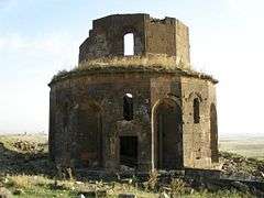 Ruins of Gharghavank on a hillside of Mount Ara
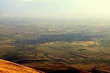 View of Yeghvard from Mount Ara
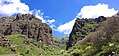 Rock formations
References
- 1 2 Lebedev, V. A.; Chernyshev, I. V.; Yakushev, A. I. (2011). "Initial time and duration of quaternary magmatism in the Aragats neovolcanic area (Lesser Caucasus, Armenia)". Doklady Earth Sciences. 437 (2): 532–536. doi:10.1134/S1028334X11040209. ISSN 1028-334X.
- ↑ Khachatur Meliketsian (August 2013). Pliocene-Quaternary volcanism of the Syunik upland (Armenia) (Report). Veröffentlichungen des Landesamtes für Denkmalpflege und Archäologie Sachsen-Anhalt. p. 249. Retrieved 9 July 2015.
- ↑ Dr. Gayane Karagyan. Identification of Priority Areas for the Conservation of Endangered Insect Species of Ararat Valley in Armenia (Report). The Rufford Foundation. pp. 15–16.
- ↑ Armenian Bird Census Council. Important Bird and Biodiversity Areas in Armenia. TSE NGO. Retrieved on 29 Oct 2017 from http://www.abcc-am.org/iba.html
| Wikimedia Commons has media related to Mount Ara. |