Apple River (Illinois)
| Apple River | |
| River | |
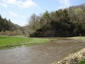 The confluence of the South Fork Apple River and the Apple River within Apple River Canyon State Park | |
| Country | United States |
|---|---|
| State | Illinois, Wisconsin |
| Source | |
| - location | East of Shullsburg, Lafayette County, Wisconsin |
| - coordinates | 42°33′51″N 90°09′47″W / 42.56417°N 90.16306°W |
| Mouth | Mississippi River |
| - location | Northwest of Savanna, Carroll County, Illinois |
| - coordinates | 42°10′35″N 90°14′36″W / 42.17639°N 90.24333°WCoordinates: 42°10′35″N 90°14′36″W / 42.17639°N 90.24333°W |
| Length | 55 mi (89 km) |
The Apple River is a tributary of the Mississippi River, about 55 miles (89 km) long,[1] in southwestern Wisconsin and northwestern Illinois in the United States. It rises in Lafayette County, Wisconsin, and flows for most of its length in Illinois, through Jo Daviess and Carroll Counties. Along its course it passes through Apple River Canyon State Park and the town of Hanover. It flows into the Mississippi River about 7 mi (11 km) northwest of Savanna.
In Jo Daviess County, it collects two short tributaries known as the West Fork Apple River and South Fork Apple River.
Toponymy
Apple River was so named on account of the crabapple trees along its course.[2] A folk etymology maintains the river derives its name from a German named Appel who fell near the river in the Black Hawk War.[2]
Geology
The river is part of the Driftless Area of Illinois, a region that was bypassed by the last ice age; "the glacial sweep which ironed out hills and filled valleys in other parts of the state left this area unscratched.[3] The Apple River had its original course reversed, it now flowing southwest to the Mississippi.[4] The result is a deep canyon, part of which is preserved in Apple River Canyon State Park.
See also
Notes
- ↑ U.S. Geological Survey. National Hydrography Dataset high-resolution flowline data. The National Map Archived 2012-04-05 at WebCite, accessed May 13, 2011
- 1 2 Illinois Central Magazine. Illinois Central Railroad Company. 1922. p. 42.
- ↑ Illinois Department of Natural Resources Archived July 1, 2007, at the Wayback Machine., Retrieved July 12, 2007
- ↑ Illinois DNR on Driftless Area Archived November 6, 2007, at the Wayback Machine., Retrieved July 12, 2007
References
- Columbia Gazetteer of North America entry
- DeLorme (2003). Illinois Atlas & Gazetteer. Yarmouth, Maine: DeLorme. ISBN 0-89933-321-4.
- DeLorme (1992). Wisconsin Atlas & Gazetteer. Freeport, Maine: DeLorme. ISBN 0-89933-247-1.
- U.S. Geological Survey Geographic Names Information System: Apple River
- U.S. Geological Survey Geographic Names Information System: South Fork Apple River
- U.S. Geological Survey Geographic Names Information System: West Fork Apple River
- Prairie Rivers Network