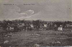
Andover, New Jersey
| Andover, New Jersey | |
|---|---|
| Borough | |
| Borough of Andover | |
 Andover, New Jersey | |
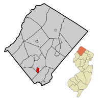 Map of Andover Borough in Sussex County. Inset: Location of Sussex County in New Jersey. | |
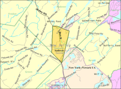 Census Bureau map of Andover, New Jersey. | |
| Coordinates: 40°59′09″N 74°44′37″W / 40.985758°N 74.74359°WCoordinates: 40°59′09″N 74°44′37″W / 40.985758°N 74.74359°W[1][2] | |
| Country |
|
| State |
|
| County | Sussex |
| Incorporated | March 25, 1904 |
| Named for | Andover, Hampshire, England |
| Government[3] | |
| • Type | Borough |
| • Body | Borough Council |
| • Mayor | John A. Morgan (R, term ends December 31, 2019)[4][5] |
| • Municipal clerk | Beth Brothman[4][6] |
| Area[1] | |
| • Total | 1.471 sq mi (3.810 km2) |
| • Land | 1.452 sq mi (3.761 km2) |
| • Water | 0.019 sq mi (0.048 km2) 1.27% |
| Area rank |
454th of 566 in state 21st of 24 in county[1] |
| Elevation[7] | 646 ft (197 m) |
| Population (2010)[8][9][10] | |
| • Total | 606 |
| • Estimate (2016)[11] | 571 |
| • Rank |
549th of 566 in state 23rd of 24 in county[12] |
| • Density | 417.3/sq mi (161.1/km2) |
| • Density rank |
458th of 566 in state 10th of 24 in county[12] |
| Time zone | UTC-5 (Eastern (EST)) |
| • Summer (DST) | UTC-4 (Eastern (EDT)) |
| ZIP Code | 07821[13][14] |
| Area code(s) | 973 exchange: 786[15] |
| FIPS code | 3403701330[1][16][17] |
| GNIS feature ID | 885140[18] |
| Website |
www |
Andover is a borough in Sussex County, New Jersey, United States. As of the 2010 United States Census, the borough's population was 606,[8][9][10] reflecting a decline of 52 (-7.9%) from the 658 counted in the 2000 Census, which had in turn declined by 42 (-6.0%) from the 700 counted in the 1990 Census.[19]
Andover was incorporated as a borough by an act of the New Jersey Legislature on March 25, 1904, from portions of Andover Township.[20] The borough was named for Andover, Hampshire, England.[21]
Geography
According to the United States Census Bureau, the borough had a total area of 1.471 square miles (3.810 km2), including 1.452 square miles (3.761 km2) of land and 0.019 square miles (0.048 km2) of water (1.27%).[1][2]
Demographics
| Historical population | |||
|---|---|---|---|
| Census | Pop. | %± | |
| 1910 | 884 | — | |
| 1920 | 417 | −52.8% | |
| 1930 | 479 | 14.9% | |
| 1940 | 512 | 6.9% | |
| 1950 | 560 | 9.4% | |
| 1960 | 734 | 31.1% | |
| 1970 | 813 | 10.8% | |
| 1980 | 892 | 9.7% | |
| 1990 | 700 | −21.5% | |
| 2000 | 658 | −6.0% | |
| 2010 | 606 | −7.9% | |
| Est. 2016 | 571 | [11][22] | −5.8% |
| Population sources: 1910-1920[23] 1910[24] 1910-1930[25] 1930-1990[26] 2000[27][28] 2010[8][9][10] | |||
Census 2010
As of the 2010 United States Census, there were 606 people, 241 households, and 163.9 families residing in the borough. The population density was 417.3 per square mile (161.1/km2). There were 263 housing units at an average density of 181.1 per square mile (69.9/km2). The racial makeup of the borough was 91.75% (556) White, 1.16% (7) Black or African American, 0.33% (2) Native American, 2.15% (13) Asian, 0.00% (0) Pacific Islander, 2.64% (16) from other races, and 1.98% (12) from two or more races. Hispanic or Latino of any race were 7.59% (46) of the population.[8]
There were 241 households out of which 28.6% had children under the age of 18 living with them, 50.6% were married couples living together, 12.4% had a female householder with no husband present, and 32.0% were non-families. 22.8% of all households were made up of individuals, and 9.1% had someone living alone who was 65 years of age or older. The average household size was 2.51 and the average family size was 2.91.[8]
In the borough, the population was spread out with 21.1% under the age of 18, 7.6% from 18 to 24, 28.7% from 25 to 44, 30.5% from 45 to 64, and 12.0% who were 65 years of age or older. The median age was 40.4 years. For every 100 females there were 99.3 males. For every 100 females ages 18 and older there were 100.8 males.[8]
The Census Bureau's 2006-2010 American Community Survey showed that (in 2010 inflation-adjusted dollars) median household income was $67,000 (with a margin of error of +/- $20,882) and the median family income was $78,889 (+/- $19,386). Males had a median income of $54,583 (+/- $21,861) versus $41,667 (+/- $24,816) for females. The per capita income for the borough was $34,262 (+/- $7,656). About 6.7% of families and 12.7% of the population were below the poverty line, including 21.3% of those under age 18 and 0.0% of those age 65 or over.[29]
Census 2000
As of the 2000 United States Census[16] there were 658 people, 261 households, and 180 families residing in the borough. The population density was 451.9 people per square mile (174.0/km2). There were 273 housing units at an average density of 187.5 per square mile (72.2/km2). The racial makeup of the borough was 92.71% White, 2.28% African American, 0.76% Native American, 2.28% Asian, 0.15% Pacific Islander, 1.22% from other races, and 0.61% from two or more races. Hispanic or Latino of any race were 2.58% of the population.[27][28]
There were 261 households out of which 29.1% had children under the age of 18 living with them, 50.6% were married couples living together, 14.2% had a female householder with no husband present, and 30.7% were non-families. 24.9% of all households were made up of individuals and 6.5% had someone living alone who was 65 years of age or older. The average household size was 2.52 and the average family size was 2.98.[27][28]
In the borough the population was spread out with 21.7% under the age of 18, 7.6% from 18 to 24, 35.3% from 25 to 44, 25.5% from 45 to 64, and 9.9% who were 65 years of age or older. The median age was 38 years. For every 100 females, there were 103.7 males. For every 100 females age 18 and over, there were 98.8 males.[27][28]
The median income for a household in the borough was $60,000, and the median income for a family was $69,688. Males had a median income of $38,056 versus $30,950 for females. The per capita income for the borough was $25,914. None of the families and 2.8% of the population were living below the poverty line, including no under eighteens and 9.1% of those over 64.[27][28]
Government
Local government
Andover is governed under the Borough form of New Jersey municipal government. The governing body consists of a Mayor and a Borough Council comprising six council members, with all positions elected at-large on a partisan basis as part of the November general election. A Mayor is elected directly by the voters to a four-year term of office. The Borough Council consists of six members elected to serve three-year terms on a staggered basis, with two seats coming up for election each year in a three-year cycle.[3] The Borough form of government used by Andover, the most common system used in the state, is a "weak mayor / strong council" government in which council members act as the legislative body with the mayor presiding at meetings and voting only in the event of a tie. The mayor can veto ordinances subject to an override by a two-thirds majority vote of the council. The mayor makes committee and liaison assignments for council members, and most appointments are made by the mayor with the advice and consent of the council.[30][31]
As of 2016, the Mayor of Andover Borough is Republican John A. Morgan, whose term of office ends December 31, 2019. Members of the Borough Council are Council President Michael Figueiredo (D, 2016; elected to serve an unexpired term), Lynn T. Delfing (R, 2017), Melvin Dennison (R, 2018), John Hoag (R, 2017; appointed to serve an unexpired term until November 2016 election), Peter Pearson (D, 2016) and Robert L. Smith (R, 2018).[4][32][33][34][35]
In February 2016, the Borough Council chose John Hoag from three candidates proposed by the Republican municipal committee to fill the seat that had been held Eskil S. Danielson that will expire in December 2017; Hoag will serve on an interim basis until the November 2016 general election, when voters will choose someone to serve the balance of the term.[36]
In February 2015, the Borough Council selected Michael Figueiredo from a list of three candidates nominated by the Democratic municipal committee to fill the seat expiring in December 2016 that became vacant when Deborah McGowan resigned from office.[37] Figueiredo served on an interim basis until the November 2015 general election, when he was elected to serve the one year remaining on the term of office.[33]
Federal, state and county representation
Andover Borough is located in the 5th Congressional district[38] and is part of New Jersey's 24th state legislative district.[9][39][40]
New Jersey's Fifth Congressional District is represented by Josh Gottheimer (D, Wyckoff).[41] New Jersey is represented in the United States Senate by Democrats Cory Booker (Newark, term ends 2021)[42] and Bob Menendez (Paramus, 2019).[43][44]
For the 2018–2019 session (Senate, General Assembly), the 24th Legislative District of the New Jersey Legislature is represented in the State Senate by Steve Oroho (R, Franklin) and in the General Assembly by Parker Space (R, Wantage Township) and Harold J. Wirths (R, Hardyston Township).[45][46] The Governor of New Jersey is Phil Murphy (D, Middletown Township).[47] The Lieutenant Governor of New Jersey is Sheila Oliver (D, East Orange).[48]
Sussex County is governed by a Board of Chosen Freeholders whose five members are elected at-large in partisan elections on a staggered basis, with either one or two seats coming up for election each year. At an annual reorganization meeting held in the beginning of January, the board selects a Freeholder Director and Deputy Director from among its members, with day-to-day supervision of the operation of the county delegated to a County Administrator.[49] As of 2014, Sussex County's Freeholders are Freeholder Director Richard Vohden (R, Green Township, 2016),[50] Deputy Director Dennis J. Mudrick (R, Sparta Township, 2015),[51] Phillip R. Crabb (R, Franklin, 2014),[52] George Graham (R, Stanhope, 2016)[53] and Gail Phoebus (R, Andover Township, 2015).[54][49] Graham was chosen in April 2013 to fill the seat vacated by Parker Space, who had been chosen to fill a vacancy in the New Jersey General Assembly.[55] Constitutional officers elected on a countywide basis are County Clerk Jeff Parrott (R, 2016),[56] Sheriff Michael F. Strada (R, 2016)[57] and Surrogate Gary R. Chiusano (R, filling the vacancy after the resignation of Nancy Fitzgibbons).[58][55] The County Administrator is John Eskilson.[59][60]
Politics
As of March 23, 2011, there were a total of 403 registered voters in Andover, of which 109 (27.0% vs. 16.5% countywide) were registered as Democrats, 152 (37.7% vs. 39.3%) were registered as Republicans and 142 (35.2% vs. 44.1%) were registered as Unaffiliated. There were no voters registered to other parties.[61] Among the borough's 2010 Census population, 66.5% (vs. 65.8% in Sussex County) were registered to vote, including 84.3% of those ages 18 and over (vs. 86.5% countywide).[61][62]
In the 2012 presidential election, Republican Mitt Romney received 143 votes (50.9% vs. 59.4% countywide), ahead of Democrat Barack Obama with 129 votes (45.9% vs. 38.2%) and other candidates with 8 votes (2.8% vs. 2.1%), among the 281 ballots cast by the borough's 400 registered voters, for a turnout of 70.3% (vs. 68.3% in Sussex County).[63] In the 2008 presidential election, Republican John McCain received 139 votes (49.5% vs. 59.2% countywide) tied with Democrat Barack Obama with 139 votes (49.5% vs. 38.7%) and other candidates with 2 votes (0.7% vs. 1.5%), among the 281 ballots cast by the borough's 404 registered voters, for a turnout of 69.6% (vs. 76.9% in Sussex County).[64] In the 2004 presidential election, Republican George W. Bush received 171 votes (55.5% vs. 63.9% countywide), ahead of Democrat John Kerry with 134 votes (43.5% vs. 34.4%) and other candidates with one vote (0.3% vs. 1.3%), among the 308 ballots cast by the borough's 421 registered voters, for a turnout of 73.2% (vs. 77.7% in the whole county).[65]
In the 2013 gubernatorial election, Republican Chris Christie received 61.6% of the vote (106 cast), ahead of Democrat Barbara Buono with 32.6% (56 votes), and other candidates with 5.8% (10 votes), among the 173 ballots cast by the borough's 396 registered voters (1 ballot was spoiled), for a turnout of 43.7%.[66][67] In the 2009 gubernatorial election, Republican Chris Christie received 117 votes (58.8% vs. 63.3% countywide), ahead of Democrat Jon Corzine with 61 votes (30.7% vs. 25.7%), Independent Chris Daggett with 18 votes (9.0% vs. 9.1%) and other candidates with 2 votes (1.0% vs. 1.3%), among the 199 ballots cast by the borough's 386 registered voters, yielding a 51.6% turnout (vs. 52.3% in the county).[68]
Education
Public school students in pre-kindergarten through eighth grade attend the Andover Regional School District, together with students from Andover Township.[69] As of the 2014-15 school year, the district and its two schools had an enrollment of 852 students and 55.3 classroom teachers (on an FTE basis), for a student–teacher ratio of 15.4:1.[70] Schools in the district (with 2014-15 enrollment data from the National Center for Education Statistics[71]) are Florence M. Burd Elementary School[72] (Grades PreK-4, 279 students) and Long Pond Middle School[73] (Grades 5-8, 280 students).[74][75]
Public school students in ninth through twelfth grades attend Newton High School in Newton, together with students from Andover Township and Green Township, as part of a sending/receiving relationship with the Newton Public School District.[76][77] As of the 2015-16 school year, the high school had an enrollment of 760 students and 68.5 classroom teachers (on an FTE basis), for a student–teacher ratio of 11.1:1.[78]
Since 1972, Lakeland Andover School has been operating as a therapeutic, nonprofit, private day school for students in grades 7-12, serving the educational and vocational training needs of students with emotional and behavioral challenges.[79]
Law enforcement is covered by the New Jersey State Police Fire Dept is covered by Andover Borough Volunteer Fire Dept and EMS is Lakeland Emergency Squad
Transportation
Roads and highways
As of May 2010, the borough had a total of 7.41 miles (11.93 km) of roadways, of which 1.92 miles (3.09 km) were maintained by the municipality, 3.18 miles (5.12 km) by Sussex County and 2.31 miles (3.72 km) by the New Jersey Department of Transportation.[80]
U.S. Route 206 and County Route 517 pass through the borough.
Public transportation
Lakeland Bus Lines provides service operating along Interstate 80 between Newton, New Jersey and the Port Authority Bus Terminal in Midtown Manhattan.[81]
As part of restoring train service via the Lackawanna Cut-Off, funding has been secured to rebuild a 7.3 miles (11.7 km) stretch of the railroad to a new station in Andover, which is projected to open in 2019.[82]
Aeroflex-Andover Airport is located 2 miles (3.2 km) north of the central business district and Trinca Airport, 3 miles (4.8 km) southwest.
Notable people
People who were born in, residents of, or otherwise closely associated with Andover include:
- Stephen M. Balzer (c. 1864 – 1940), mechanic and developer of an early car and airplane engine.[83]
- Kenneth Burke (1897–1993), cultural and literary critic and philosopher; Harry and Tom Chapin's grandfather.[84]
- Finn M. W. Caspersen (1941-2009), financier and philanthropist.[85]
- Newman E. Drake (1860–1930), founder of the Drake's baking company.[86]
- Rob Freeman (born 1981), member of Hidden in Plain View.[87]
References
- 1 2 3 4 5 2010 Census Gazetteer Files: New Jersey Places, United States Census Bureau. Accessed May 21, 2015.
- 1 2 US Gazetteer files: 2010, 2000, and 1990, United States Census Bureau. Accessed September 4, 2014.
- 1 2 2012 New Jersey Legislative District Data Book, Rutgers University Edward J. Bloustein School of Planning and Public Policy, March 2013, p. 110.
- 1 2 3 Directory and Contacts, Andover Borough. Accessed August 1, 2016.
- ↑ 2018 New Jersey Mayors Directory, New Jersey Department of Community Affairs. Accessed March 15, 2018.
- ↑ Municipal Clerks / Registrars List, Sussex County, New Jersey Clerk. Accessed March 18, 2018.
- ↑ U.S. Geological Survey Geographic Names Information System: Borough of Andover, Geographic Names Information System. Accessed March 4, 2013.
- 1 2 3 4 5 6 DP-1 - Profile of General Population and Housing Characteristics: 2010 for Andover borough, Sussex County, New Jersey, United States Census Bureau. Accessed February 18, 2013.
- 1 2 3 4 Municipalities Grouped by 2011-2020 Legislative Districts, New Jersey Department of State, p. 10. Accessed January 6, 2013.
- 1 2 3 Profile of General Demographic Characteristics: 2010 for Andover borough, New Jersey Department of Labor and Workforce Development. Accessed February 18, 2013.
- 1 2 PEPANNRES - Annual Estimates of the Resident Population: April 1, 2010 to July 1, 2016 - 2016 Population Estimates for New Jersey municipalities, United States Census Bureau. Accessed June 16, 2017.
- 1 2 GCT-PH1 Population, Housing Units, Area, and Density: 2010 - State -- County Subdivision from the 2010 Census Summary File 1 for New Jersey, United States Census Bureau. Accessed December 11, 2012.
- ↑ Look Up a ZIP Code for Andover, NJ, United States Postal Service. Accessed February 18, 2013.
- ↑ ZIP Codes, State of New Jersey. Accessed August 23, 2013.
- ↑ Area Code Lookup - NPA NXX for Andover, NJ, Area-Codes.com. Accessed September 18, 2014.
- 1 2 American FactFinder, United States Census Bureau. Accessed September 4, 2014.
- ↑ Geographic Codes Lookup for New Jersey, Missouri Census Data Center. Accessed October 26, 2012.
- ↑ US Board on Geographic Names, United States Geological Survey. Accessed September 4, 2014.
- ↑ Table 7. Population for the Counties and Municipalities in New Jersey: 1990, 2000 and 2010, New Jersey Department of Labor and Workforce Development, February 2011. Accessed February 18, 2013.
- ↑ Snyder, John P. The Story of New Jersey's Civil Boundaries: 1606-1968, Bureau of Geology and Topography; Trenton, New Jersey; 1969. p. 230. Accessed October 25, 2012.
- ↑ Hutchinson, Viola L. The Origin of New Jersey Place Names, New Jersey Public Library Commission, May 1945. Accessed August 26, 2015.
- ↑ Census Estimates for New Jersey April 1, 2010 to July 1, 2016, United States Census Bureau. Accessed June 16, 2017.
- ↑ Compendium of censuses 1726-1905: together with the tabulated returns of 1905, New Jersey Department of State, 1906. Accessed August 23, 2013.
- ↑ Thirteenth Census of the United States, 1910: Population by Counties and Minor Civil Divisions, 1910, 1900, 1890, United States Census Bureau, p. 338. Accessed February 18, 2013.
- ↑ Fifteenth Census of the United States : 1930 - Population Volume I, United States Census Bureau, p. 719. Accessed February 18, 2013.
- ↑ New Jersey Resident Population by Municipality: 1930 - 1990, Workforce New Jersey Public Information Network. Accessed June 28, 2015.
- 1 2 3 4 5 Census 2000 Profiles of Demographic / Social / Economic / Housing Characteristics for Andover borough, New Jersey, United States Census Bureau. Accessed February 18, 2013.
- 1 2 3 4 5 DP-1: Profile of General Demographic Characteristics: 2000 - Census 2000 Summary File 1 (SF 1) 100-Percent Data for Andover borough, Sussex County, New Jersey, United States Census Bureau. Accessed February 18, 2013.
- ↑ DP03: Selected Economic Characteristics from the 2006-2010 American Community Survey 5-Year Estimates for Andover borough, Sussex County, New Jersey, United States Census Bureau. Accessed February 18, 2013.
- ↑ Cerra, Michael F. "Forms of Government: Everything You've Always Wanted to Know, But Were Afraid to Ask", New Jersey State League of Municipalities. Accessed November 30, 2014.
- ↑ "Forms of Municipal Government in New Jersey", p. 6. Rutgers University Center for Government Studies. Accessed June 3, 2015.
- ↑ 2016 Municipal Data Sheet, Andover Borough. Accessed August 1, 2016.
- 1 2 Sussex County General Election November 3, 2015 Summary Report Official Results, Sussex County, New Jersey Clerk, updated November 6, 2015. Accessed August 1, 2016.
- ↑ Sussex County General Election November 4, 2014 Summary Report Official Results, Sussex County, New Jersey Clerk, updated November 10, 2014. Accessed August 1, 2016.
- ↑ Sussex County General and School Election November 5, 2013 Summary Report Official Results, Sussex County, New Jersey Clerk, updated November 7, 2013. Accessed August 1, 2016.
- ↑ Borough Council February 8, 2016, Regular Meeting Minutes, Borough of Andover. Accessed August 1, 2016.
- ↑ 2-9-2015.pdf Borough Council February 9, 2015, Regular Meeting Minutes, Borough of Andover. Accessed August 1, 2016.
- ↑ Plan Components Report, New Jersey Redistricting Commission, December 23, 2011. Accessed January 6, 2013.
- ↑ 2017 New Jersey Citizen's Guide to Government, p. 54, New Jersey League of Women Voters. Accessed May 30, 2017.
- ↑ Districts by Number for 2011-2020, New Jersey Legislature. Accessed January 6, 2013.
- ↑ Directory of Representatives: New Jersey, United States House of Representatives. Accessed January 5, 2012.
- ↑ About Cory Booker, United States Senate. Accessed January 26, 2015. "He now owns a home and lives in Newark's Central Ward community."
- ↑ Biography of Bob Menendez, United States Senate, January 26, 2015. "He currently lives in Paramus and has two children, Alicia and Robert."
- ↑ Senators of the 114th Congress from New Jersey. United States Senate. Accessed January 26, 2015. "Booker, Cory A. - (D - NJ) Class II; Menendez, Robert - (D - NJ) Class I"
- ↑ Legislative Roster 2018-2019 Session, New Jersey Legislature. Accessed January 22, 2018.
- ↑ District 24 Legislators, New Jersey Legislature. Accessed January 22, 2018.
- ↑ Governor Phil Murphy, State of New Jersey. Accessed January 16, 2018.
- ↑ Lieutenant Governor Oliver, State of New Jersey. Accessed January 16, 2018. "Assemblywoman Oliver has resided in the City of East Orange for over 40 years."
- 1 2 Sussex County Board of Chosen Freeholders, Sussex County, New Jersey. Accessed July 28, 2014.
- ↑ Richard A. Vohden, Sussex County, New Jersey. Accessed July 28, 2014.
- ↑ Dennis J. Mudrick, Sussex County, New Jersey. Accessed July 28, 2014.
- ↑ Phillip R. Crabb, Sussex County, New Jersey. Accessed July 28, 2014.
- ↑ George Graham, Sussex County, New Jersey. Accessed July 28, 2014.
- ↑ Gail Phoebus, Sussex County, New Jersey. Accessed July 28, 2014.
- 1 2 Miller, Jennifer Jean. "George Graham Chosen as Freeholder at Sussex County Republican Convention", TheAlternativePress.com, April 13, 2013. Accessed April 25, 2013. "Graham will fill the freeholder seat that New Jersey Assemblyman Parker Space left to take his new position. Space recently took the seat, which formerly belonged to Gary Chiusano, who in turn, was appointed to the spot of Sussex County Surrogate, following the retirement of Surrogate Nancy Fitzgibbons."
- ↑ Home Page, Sussex County Clerk's Office. Accessed July 28, 2014.
- ↑ Sheriff's Office, Sussex County, New Jersey. Accessed July 28, 2014.
- ↑ Home Page, Sussex County Surrogate. Accessed July 28, 2014.
- ↑ County Administrator, Sussex County, New Jersey. Accessed July 28, 2014.
- ↑ Sussex County Official Directory 2014, Sussex County, New Jersey. Accessed July 28, 2014.
- 1 2 Voter Registration Summary - Sussex, New Jersey Department of State Division of Elections, March 23, 2011. Accessed February 17, 2013.
- ↑ GCT-P7: Selected Age Groups: 2010 - State -- County Subdivision; 2010 Census Summary File 1 for New Jersey, United States Census Bureau. Accessed February 17, 2013.
- ↑ General Election November 6, 2012: District Report - Group Detail Archived June 6, 2013, at the Wayback Machine., Sussex County, New Jersey Clerk, run date November 30, 2012. Accessed February 20, 2013.
- ↑ 2008 Presidential General Election Results: Sussex County, New Jersey Department of State Division of Elections, December 23, 2008. Accessed February 17, 2013.
- ↑ 2004 Presidential Election: Sussex County, New Jersey Department of State Division of Elections, December 13, 2004. Accessed February 17, 2013.
- ↑ "Governor - Sussex County" (PDF). New Jersey Department of Elections. January 29, 2014. Retrieved December 24, 2014.
- ↑ "Number of Registered Voters and Ballots Cast - November 5, 2013 - General Election Results - Sussex County" (PDF). New Jersey Department of Elections. January 29, 2014. Retrieved December 24, 2014.
- ↑ 2009 Governor: Sussex County, New Jersey Department of State Division of Elections, December 31, 2009. Accessed February 17, 2013.
- ↑ Home Page, Andover Regional School District. Accessed January 3, 2017. "Our Board of Education is comprised of nine members representing both Andover Borough and Andover Township.Students in grades Pre-K, 1, 2, 3, 4 attend the Florence M. Burd School and students in grades 5, 6, 7, 8 attend the Long Pond School. Our eighth grade graduates attend Newton High School through a longtime send/receive relationship with the Newton Public Schools."
- ↑ District information for Andover Regional School District, National Center for Education Statistics. Accessed December 7, 2016.
- ↑ School Data for the Andover Regional School District, National Center for Education Statistics. Accessed December 7, 2016.
- ↑ Florence M. Burd Elementary School, Andover Regional School District. Accessed January 3, 2017.
- ↑ Long Pond Middle School, Andover Regional School District. Accessed January 3, 2017.
- ↑ Our Schools, Andover Regional School District. Accessed January 3, 2017.
- ↑ New Jersey School Directory for the Andover Regional School District, New Jersey Department of Education. Accessed December 29, 2016.
- ↑ Newton High School 2013 Report Card Narrative, New Jersey Department of Education. Accessed July 14, 2016. "Newton High School serves students from Andover Township, Andover Borough, and Green Township as well as historic Newton."
- ↑ About Us Archived 2013-01-28 at the Wayback Machine., Newton Public School District. Accessed September 18, 2014. "The Newton Public School District is a K-12 district with an enrollment over 1,500 students in our elementary, middle, and high schools. The high school is home to Newton residents as well as students from neighboring Andover Borough, Andover Township, and Green Township."
- ↑ School data for Newton High School, National Center for Education Statistics. Accessed February 12, 2018.
- ↑ Who We Are, Lakeland Andover School. Accessed March 15, 2018. "Lakeland Andover School is a therapeutic, nonprofit, private day school whose primary purpose is the education of emotionally and behaviorally challenged 7th - 12th grade students. We have been offering state approved, success-oriented academic and vocational programs since 1972."
- ↑ Sussex County Mileage by Municipality and Jurisdiction, New Jersey Department of Transportation, May 2010. Accessed July 18, 2014.
- ↑ Route 80 - Eastbound to New York - Monday - Friday, Lakeland Bus Lines. Accessed March 15, 201.
- ↑ 2007-2008 Annual Report Archived 2011-01-01 at the Wayback Machine., New Jersey Association of Railroad Passengers. Accessed January 2, 2011.
- ↑ Balzer automobile patents, Smithsonian Institution America on the Move. Accessed April 22, 2017. "Stephen Marius Balzer (1864?-1940) was an inventor and early automobile manufacturer.... He originally lived in the Bronx, but had moved to Andover New Jersey by the time of his death in 1940."
- ↑ "Kenneth Burke, 96 Philosopher, Writer On Language", Boston Globe, November 22, 1993. Accessed July 16, 2008. "Kenneth Burke, a philosopher who was influential in American literary circles, has died. He was 96. Mr. Burke died Friday of heart failure at his home in Andover, N.J."
- ↑ Cohan, William D. "The Shot Heard 'Round the Clubs", Vanity Fair (magazine), January 5, 2010. Accessed April 22, 2017 "The Caspersens eventually moved to Andover, New Jersey, and Venice, Florida.... The Caspersens had had homes in the area, in both Andover and Bernardsville."
- ↑ Staff. "Newman E. Drake Dies After Operation; Founder of Bakery Concern Bearing Family Name--Spent Youth on Farm.", The New York Times, March 20, 1930. Accessed April 21, 2017. "Mr. Drake was born on Dec. 16, 1860, at Andover, N. J., the sone of John B. and Elizabeth Stackhouse Drake, and was educated in the public schools of Newton."
- ↑ Bove, Stephen. "Coming in for a Landing", Asbury Park Press, March 30, 2007. Accessed June 2, 2011. "Made up of Andover-born singer/songwriter Rob Freeman (guitarist and singer for Hidden in Plain View) on vocals, guitars, piano and drums along with Jason Jaksetic on bass and guitars, The Pilot has been writing and recording copious amounts of material while touring and performing regular acoustic sets..."
External links
- Andover Borough website
- Andover Regional School District
- Data for Andover Regional School District, National Center for Education Statistics
- Newton High School
- The Township Journal, community newspaper
- Abandoned Mines of Andover, New Jersey
Municipalities and communities of Sussex County, New Jersey, United States | ||
|---|---|---|
| Boroughs | 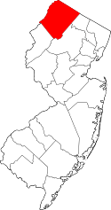 | |
| Town | ||
| Townships | ||
| CDPs | ||
| Other unincorporated communities | ||