Palian District
| Palian ปะเหลียน | |
|---|---|
| District | |
 Yong Star Cape | |
 District location in Trang Province | |
| Coordinates: 7°10′18″N 99°41′12″E / 7.17167°N 99.68667°ECoordinates: 7°10′18″N 99°41′12″E / 7.17167°N 99.68667°E | |
| Country | Thailand |
| Province | Trang |
| Seat | Tha Kham |
| Area | |
| • Total | 973.13 km2 (375.73 sq mi) |
| Population (2005) | |
| • Total | 62,914 |
| • Density | 64.7/km2 (168/sq mi) |
| Time zone | UTC+7 (ICT) |
| Postal code | 92120 |
| Geocode | 9204 |
Palian (Thai: ปะเหลียน, pronounced [pā.lǐa̯n]) is a district (amphoe) in the southern part of Trang Province, Thailand.
Geography
Neighboring districts are (from the east clockwise) Kong Ra, Tamot, and Pa Bon of Phatthalung Province, Khuan Kalong, Manang, and Thung Wa of Satun Province, Hat Samran and Yan Ta Khao of Trang Province.
History
Originally named Yong Sata (หยงสตา), it was renamed Palian in 1939.[1]
Administration
The district is divided into 10 sub-districts (tambons), which are further subdivided into 85 villages (mubans). Tha Kham is a township (thesaban tambon) which covers parts of tambon Tha Kham. There are a further 10 tambon administrative organizations (TAO).
|
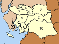 |
Missing numbers are tambon which now form Hat Samran District.
References
- ↑ พระราชกฤษฎีกาเปลี่ยนนามอำเภอ กิ่งอำเภอ และตำบลบางแห่ง พุทธศักราช ๒๔๘๒ (PDF). Royal Gazette (in Thai). 56 (0 ก): 354–364. April 17, 1939.
External links
- http://www.palian.dopatrang.go.th%5Bpermanent+dead+link%5D Website of district (Thai only)
- amphoe.com
This article is issued from
Wikipedia.
The text is licensed under Creative Commons - Attribution - Sharealike.
Additional terms may apply for the media files.