Khlong Khuean District
| Khlong Khuean คลองเขื่อน | |
|---|---|
| Amphoe | |
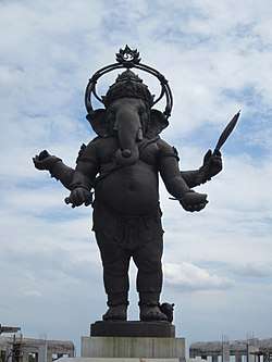 Bronze Ganesh at the Khlong Khuean Ganesh International Park | |
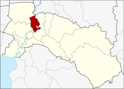 Amphoe location in Chachoengsao Province | |
| Coordinates: 13°47′29″N 101°9′47″E / 13.79139°N 101.16306°ECoordinates: 13°47′29″N 101°9′47″E / 13.79139°N 101.16306°E | |
| Country | Thailand |
| Province | Chachoengsao |
| Seat | Khlong Khuean |
| Area | |
| • Total | 127.4 km2 (49.2 sq mi) |
| Population (2017) | |
| • Total | 13,065 |
| • Density | 102.55/km2 (265.6/sq mi) |
| Time zone | UTC+7 (ICT) |
| Postal code | 24000 |
| Geocode | 2411 |
Khlong Khuean (Thai: คลองเขื่อน, pronounced [kʰlɔ̄ːŋ kʰɯ̀a̯n]) is a district (amphoe) of Chachoengsao Province, central Thailand.
History
The district was created on 31 May 1993 by splitting it from Bang Khla District.[1]
On 15 May 2007, all 81 minor districts were upgraded to full districts.[2] With publication in the Royal Gazette on 24 August the upgrade became official.[3]
Geography
Neighboring districts are (from the east clockwise) Bang Khla, Mueang Chachoengsao, and Bang Nam Priao of Chachoengsao Province and Ban Sang of Prachinburi Province.
The important water resource is the Bang Pakong River.
Administration
Central administration
Khlong Khuean is divided into five sub-district (tambons), which are further subdivided into 32 administrative villages (muban).
| No. | Name | Thai | Villages | Pop.[4] |
|---|---|---|---|---|
| 1. | Kon Kaeo | ก้อนแก้ว | 6 | 3,106 |
| 2. | Khlong Khuean | คลองเขื่อน | 6 | 3,537 |
| 3. | Bang Lao | บางเล่า | 6 | 1,943 |
| 4. | Bang Rong | บางโรง | 7 | 2,240 |
| 5. | Bang Talat | บางตลาด | 7 | 2,239 |
Local administration
There are five sub-district administrative organizations (SAO) in the district:
- Kon Kaeo (Thai: องค์การบริหารส่วนตำบลก้อนแก้ว) consisting of sub-district Kon Kaeo.
- Khlong Khuean (Thai: องค์การบริหารส่วนตำบลคลองเขื่อน) consisting of sub-district Khlong Khuean.
- Bang Lao (Thai: องค์การบริหารส่วนตำบลบางเล่า) consisting of sub-district Bang Lao.
- Bang Rong (Thai: องค์การบริหารส่วนตำบลบางโรง) consisting of sub-district Bang Rong.
- Bang Talat (Thai: องค์การบริหารส่วนตำบลบางตลาด) consisting of sub-district Bang Talat.
References
- ↑ ประกาศกระทรวงมหาดไทย เรื่อง แบ่งเขตท้องที่อำเภอบางคล้า จังหวัดฉะเชิงเทรา ตั้งเป็นกิ่งอำเภอคลองเขื่อน (PDF). Royal Gazette (in Thai). 110 (74 ง): 21. June 8, 1993.
- ↑ แถลงผลการประชุม ครม. ประจำวันที่ 15 พ.ค. 2550 (in Thai). Manager Online.
- ↑ พระราชกฤษฎีกาตั้งอำเภอฆ้องชัย...และอำเภอเหล่าเสือโก้ก พ.ศ. ๒๕๕๐ (PDF). Royal Gazette (in Thai). 124 (46 ก): 14–21. August 24, 2007.
- ↑ "Population statistics 2017" (in Thai). Department of Provincial Administration. Retrieved 2018-04-04.
External links