Almagro, Samar
| Almagro | |
|---|---|
| Municipality | |
| Municipality of Almagro | |
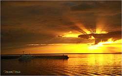 Sunset at Almagro shoreline | |
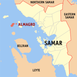 Map of Samar with Almagro highlighted | |
.svg.png) Almagro Location within the Philippines | |
| Coordinates: 11°55′N 124°17′E / 11.92°N 124.28°ECoordinates: 11°55′N 124°17′E / 11.92°N 124.28°E | |
| Country |
|
| Region | Eastern Visayas (Region VIII) |
| Province | Samar |
| District | 1st district of Samar |
| Barangays | 23 (see Barangays) |
| Government [1] | |
| • Type | Sangguniang Bayan |
| • Mayor | Kathleen S. Prudenciado |
| • Electorate | 9,404 voters (2016) |
| Area [2] | |
| • Total | 51.36 km2 (19.83 sq mi) |
| Population (2015 census)[3] | |
| • Total | 8,942 |
| • Density | 170/km2 (450/sq mi) |
| Time zone | UTC+8 (PST) |
| ZIP code | 6724 |
| PSGC | 086001000 |
| IDD : area code | +63 (0)55 |
| Climate type | Tropical rainforest climate |
| Income class | 5th municipal income class |
| Revenue (₱) | 46,240,897.29 (2016) |
| Native languages |
Cebuano Waray Tagalog |
| Website |
elgu |
Almagro, officially the Municipality of Almagro, is a 5th class municipality in the province of Samar, Philippines. According to the 2015 census, it has a population of 8,942 people.[3]
Barangays
Almagro is politically subdivided into 23 barangays.
- Bacjao
- Biasong I
- Costa Rica
- Guin-ansan
- Kerikite
- Lunang I (Look)
- Lunang II
- Malobago
- Marasbaras
- Panjobjoban I
- Poblacion
- Talahid
- Tonga-Tonga
- Imelda (Badjang)
- Biasong II
- Costa Rica II
- Mabuhay
- Magsaysay
- Panjobjoban II
- Roño
- San Isidro
- San Jose
- Veloso
Demographics
| Population census of Almagro | ||
|---|---|---|
| Year | Pop. | ±% p.a. |
| 1903 | 5,673 | — |
| 1918 | 5,216 | −0.56% |
| 1939 | 7,126 | +1.50% |
| 1948 | 9,391 | +3.11% |
| 1960 | 11,276 | +1.54% |
| 1970 | 13,977 | +2.17% |
| 1975 | 16,010 | +2.76% |
| 1980 | 10,097 | −8.80% |
| 1990 | 8,578 | −1.62% |
| 1995 | 10,270 | +3.43% |
| 2000 | 10,619 | +0.72% |
| 2007 | 8,650 | −2.79% |
| 2010 | 11,024 | +9.23% |
| 2015 | 8,942 | −3.91% |
| Source: Philippine Statistics Authority[3] [4] [5] [6] | ||
Tourist attractions
- Pang-pang (Veloso and Panjobjoban 1)
- Exotic Diving Resort (Brgy. Kerikite)
- Caves in Almagro
- Rock formation
- Museum of Endangered Species
- LightHouse (lighthouse island)
Culture
The most famous dance in Almagro is Kuratsa, because of the influence of the Spaniards that controlled the municipality for 330 years. They held their occasions on the newly constructed Covered Court in Brgy. Poblacion. Their Fiestas and Charter Days are the days where many people would come to Almagro to witness different activities held on the island. People in Almagro are often seen wearing sando because of the hot weather and the sea breeze on the island.
Transportation
The only one means of access to Almagro is by motorboat from the port of Calbayog City, taking usually up to 2 hours of travel.
References
- ↑ "Municipality". Quezon City, Philippines: Department of the Interior and Local Government. Retrieved 31 May 2013.
- ↑ "Province: Samar (Western Samar)". PSGC Interactive. Quezon City, Philippines: Philippine Statistics Authority. Retrieved 12 November 2016.
- 1 2 3 Census of Population (2015). "Region VIII (Eastern Visayas)". Total Population by Province, City, Municipality and Barangay. PSA. Retrieved 20 June 2016.
- ↑ Census of Population and Housing (2010). "Region VIII (Eastern Visayas)". Total Population by Province, City, Municipality and Barangay. NSO. Retrieved 29 June 2016.
- ↑ Censuses of Population (1903–2007). "Region VIII (Eastern Visayas)". Table 1. Population Enumerated in Various Censuses by Province/Highly Urbanized City: 1903 to 2007. NSO.
- ↑ "Province of Samar (Western Samar)". Municipality Population Data. Local Water Utilities Administration Research Division. Retrieved 17 December 2016.
External links
- Philippine Standard Geographic Code
- Philippine Census Information
- Local Governance Performance Management System
Places adjacent to Almagro, Samar | |
|---|---|