Maripipi
| Maripipi | |
|---|---|
| Municipality | |
| Municipality of Maripipi | |
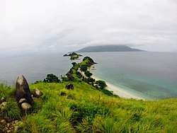 Maripipi Island as seen from Sambawan Island | |
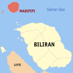 Map of Biliran with Maripipi highlighted | |
.svg.png) Maripipi Location within the Philippines | |
| Coordinates: 11°47′N 124°21′E / 11.78°N 124.35°ECoordinates: 11°47′N 124°21′E / 11.78°N 124.35°E | |
| Country |
|
| Region | Eastern Visayas (Region VIII) |
| Province | Biliran |
| District | Lone district |
| Barangays | 15 (see Barangays) |
| Government [1] | |
| • Type | Sangguniang Bayan |
| • Mayor | Uldarico P. Macorol |
| • Electorate | 4,764 voters (2016) |
| Area [2] | |
| • Total | 27.83 km2 (10.75 sq mi) |
| Population (2015 census)[3] | |
| • Total | 7,159 |
| • Density | 260/km2 (670/sq mi) |
| Time zone | UTC+8 (PST) |
| ZIP code | 6546 |
| PSGC | 087807000 |
| IDD : area code | +63 (0)53 |
| Climate type | Tropical monsoon climate |
| Income class | 5th municipal income class |
| Revenue (₱) | 38,551,713.36 (2016) |
| Native languages |
Waray Tagalog |
| Website |
www |
Maripipi, officially the Municipality of Maripipi, (Waray: Bungto san Maripipi; Cebuano: Lungsod sa Maripipi; Filipino: Bayan ng Maripipi), is a 5th class municipality in the province of Biliran, Philippines. According to the 2015 census, it has a population of 7,159 people.[3]
Geography
Maripipi is located at 11°47′N 124°21′E / 11.78°N 124.35°E, composed of Maripipi Island and surrounding islets situated northwest off the coast of Biliran Island.
According to the Philippine Statistics Authority, the municipality has a land area of 27.83 square kilometres (10.75 sq mi) [2] constituting 5.19% of the 536.01-square-kilometre- (206.95 sq mi) total area of Biliran.
Barangays
Maripipi is politically subdivided into 15 barangays.[4]
| PSGC | Barangay | Population | ±% p.a. | |||
|---|---|---|---|---|---|---|
| 2015[3] | 2010[5] | |||||
| 087807001 | Agutay | 7.3% | 523 | 511 | 0.44% | |
| 087807002 | Banlas | 3.3% | 235 | 249 | −1.10% | |
| 087807003 | Bato | 8.0% | 576 | 507 | 2.46% | |
| 087807004 | Binalayan West | 7.1% | 509 | 477 | 1.24% | |
| 087807005 | Binalayan East | 6.7% | 479 | 476 | 0.12% | |
| 087807008 | Burabod | 3.1% | 222 | 212 | 0.88% | |
| 087807009 | Calbani | 5.3% | 381 | 404 | −1.11% | |
| 087807010 | Canduhao | 5.0% | 356 | 329 | 1.51% | |
| 087807011 | Casibang | 6.0% | 431 | 379 | 2.48% | |
| 087807012 | Danao | 4.3% | 306 | 345 | −2.26% | |
| 087807014 | Ol‑og | 5.1% | 362 | 327 | 1.95% | |
| 087807015 | Binongto‑an (Poblacion Norte) | 9.1% | 653 | 578 | 2.35% | |
| 087807016 | Ermita (Poblacion Sur) | 13.8% | 988 | 831 | 3.35% | |
| 087807017 | Trabugan | 2.5% | 177 | 185 | −0.84% | |
| 087807018 | Viga | 13.4% | 961 | 889 | 1.49% | |
| Total | 7,159 | 6,699 | 1.27% | |||
Demographics
| Population census of Maripipi | |||||||||||||||||||||||||||||||||||||||||||||||||
|---|---|---|---|---|---|---|---|---|---|---|---|---|---|---|---|---|---|---|---|---|---|---|---|---|---|---|---|---|---|---|---|---|---|---|---|---|---|---|---|---|---|---|---|---|---|---|---|---|---|
|
| ||||||||||||||||||||||||||||||||||||||||||||||||
| Source: Philippine Statistics Authority[3][5][6][7] | |||||||||||||||||||||||||||||||||||||||||||||||||
In the 2015 census, Maripipi had a population of 7,159.[3] The population density was 260 inhabitants per square kilometre (670/sq mi).
References
- ↑ "Municipality". Quezon City, Philippines: Department of the Interior and Local Government. Retrieved 31 May 2013.
- 1 2 "Province: Biliran". PSGC Interactive. Quezon City, Philippines: Philippine Statistics Authority. Retrieved 12 November 2016.
- 1 2 3 4 5 Census of Population (2015). "Region VIII (Eastern Visayas)". Total Population by Province, City, Municipality and Barangay. PSA. Retrieved 20 June 2016.
- ↑ "Municipal: Maripipi". PSGC Interactive. Quezon City, Philippines: Philippine Statistics Authority. Retrieved 8 January 2016.
- 1 2 Census of Population and Housing (2010). "Region VIII (Eastern Visayas)". Total Population by Province, City, Municipality and Barangay. NSO. Retrieved 29 June 2016.
- ↑ Censuses of Population (1903–2007). "Region VIII (Eastern Visayas)". Table 1. Population Enumerated in Various Censuses by Province/Highly Urbanized City: 1903 to 2007. NSO.
- ↑ "Province of Biliran". Municipality Population Data. Local Water Utilities Administration Research Division. Retrieved 17 December 2016.
Places adjacent to Maripipi | |
|---|---|
| Municipalities | |
|---|---|