Addlestone railway station
| Addlestone | |
|---|---|
 | |
| Location | |
| Place | Addlestone |
| Local authority | Runnymede |
| Coordinates | 51°22′23″N 0°29′02″W / 51.373°N 0.484°WCoordinates: 51°22′23″N 0°29′02″W / 51.373°N 0.484°W |
| Grid reference | TQ055648 |
| Operations | |
| Station code | ASN |
| Managed by | South Western Railway |
| Number of platforms | 2 |
| DfT category | E |
|
Live arrivals/departures, station information and onward connections from National Rail Enquiries | |
| Annual rail passenger usage* | |
| 2012/13 |
|
| 2013/14 |
|
| 2014/15 |
|
| 2015/16 |
|
| 2016/17 |
|
| History | |
| Key dates | Opened 14 February 1848 |
| National Rail – UK railway stations | |
| * Annual estimated passenger usage based on sales of tickets in stated financial year(s) which end or originate at Addlestone from Office of Rail and Road statistics. Methodology may vary year on year. | |
|
| |
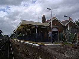
Addlestone railway station serves the town of Addlestone in the Runnymede District of Surrey, England. It is located on the Chertsey Branch of the Waterloo to Reading Line and is operated by South Western Railway.
The station was opened, with the branch line, on 14 February 1848. It comprises Up and Down platforms having brick buildings: the main building being on the Down side. There is a level crossing with Station Road (B3121) on the south side of the station. Just under a mile south of the station, the line crosses the River Wey. After leaving the station southbound trains approach Addlestone Junction and can either head westward towards Byfleet and New Haw (and subsequent stations on the South Western Main Line) or head eastward to terminate at Weybridge.
History
Opened by the London and South Western Railway, it became part of the Southern Railway during the Grouping of 1923. The line then passed on to the Southern Region of British Railways on nationalisation in 1948.
When Sectorisation was introduced, the station was served by Network SouthEast until the Privatisation of British Railways.
Services
There is a direct half-hourly service at non-peak times from the station to Waterloo via Staines and Hounslow, although it is normally quicker to change at Virginia Water for a faster service. An alternative route to Waterloo is to change at Weybridge (Mondays to Saturdays) or Byfleet & New Haw (Sundays and early mornings/late evenings only) on the South Western Main Line.
| Preceding station | Following station | |||
|---|---|---|---|---|
| Chertsey | South Western Railway Chertsey Branch |
Weybridge | ||
| South Western Railway Chertsey Branch Limited Service |
Byfleet & New Haw | |||
Connections
Bus routes 431 and 461, both operated on behalf of Surrey County Council, stop outside the station. [1]
References
- ↑ CHERTSEY, ADDLESTONE AND WEYBRIDGE (Map), 2 September 2017
- Butt, R. V. J. (1995). The Directory of Railway Stations: details every public and private passenger station, halt, platform and stopping place, past and present (1st ed.). Sparkford: Patrick Stephens Ltd. ISBN 978-1-85260-508-7. OCLC 60251199.
- Jowett, Alan (2000). Jowett's Nationalised Railway Atlas (1st ed.). Penryn, Cornwall: Atlantic Transport Publishers. ISBN 978-0-906899-99-1. OCLC 228266687.
- Jowett, Alan (March 1989). Jowett's Railway Atlas of Great Britain and Ireland: From Pre-Grouping to the Present Day (1st ed.). Sparkford: Patrick Stephens Ltd. ISBN 978-1-85260-086-0. OCLC 22311137.
External links
| Wikimedia Commons has media related to Addlestone railway station. |
| Towns, villages and neighbourhoods |
|  | |||||||||
|---|---|---|---|---|---|---|---|---|---|---|---|
| Notable parks | |||||||||||
| Churches | |||||||||||
| Education | |||||||||||
| Transport |
| ||||||||||
| Buildings and structures |
| ||||||||||
| Sports |
| ||||||||||
| Other leisure | |||||||||||
Places listed are articles notable as settlements, arranged by post town | |||||||||||