Adairville, Kentucky
| Adairville, Kentucky | |
|---|---|
| City | |
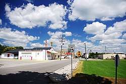 Gallatin Street (KY 591) in Adairville | |
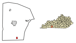 Location of Adairville in Logan County, Kentucky. | |
| Coordinates: 36°40′7″N 86°51′14″W / 36.66861°N 86.85389°WCoordinates: 36°40′7″N 86°51′14″W / 36.66861°N 86.85389°W | |
| Country | United States |
| State | Kentucky |
| County | Logan |
| Area | |
| • Total | 1.3 sq mi (3.4 km2) |
| • Land | 1.3 sq mi (3.4 km2) |
| • Water | 0.0 sq mi (0.0 km2) |
| Elevation | 600 ft (183 m) |
| Population (2010) | |
| • Total | 852 |
| • Estimate (2016)[1] | 876 |
| • Density | 705/sq mi (272.1/km2) |
| Time zone | UTC-6 (Central (CST)) |
| • Summer (DST) | UTC-5 (CDT) |
| ZIP code | 42202 |
| Area code(s) | 270 |
| FIPS code | 21-00298 |
| GNIS feature ID | 0485749 |
Adairville is a home rule-class city in Logan County, Kentucky, in the United States. Established on 31 January 1833, it was named for Governor John Adair and incorporated by the state assembly on 7 February 1871.[2][3] The population was 920 at the 2000 census.
Future president Andrew Jackson killed Charles Dickinson as the result of a duel here in 1806.[4]
History
Adairville was settled in the late 18th century, and was originally known as Dromgooles' Station. When a town was platted in 1818, its name was changed to "Adairsville" in honor the prominent Kentucky politician. The city was incorporated in 1833. The "s" had been dropped from the name by 1881.[5]
On February 24, 2018, a possible tornado killed an elderly woman, 79, on Dot Road in Adairville. [6]
Geography
According to the United States Census Bureau, the city has a total area of 1.3 square miles (3.4 km2), all land. The city is concentrated around the intersection of U.S. Route 431 (Main Street) and Kentucky Route 591 (Gallatin Street), a few miles north of the Kentucky-Tennessee state line in southwestern Logan County. The South Fork of the Red River passes along the city's southern border, and the Red River proper passes a few miles to the north.
Demographics
| Historical population | |||
|---|---|---|---|
| Census | Pop. | %± | |
| 1860 | 148 | — | |
| 1870 | 214 | 44.6% | |
| 1880 | 476 | 122.4% | |
| 1900 | 720 | — | |
| 1910 | 683 | −5.1% | |
| 1920 | 778 | 13.9% | |
| 1930 | 763 | −1.9% | |
| 1940 | 784 | 2.8% | |
| 1950 | 800 | 2.0% | |
| 1960 | 848 | 6.0% | |
| 1970 | 973 | 14.7% | |
| 1980 | 1,105 | 13.6% | |
| 1990 | 906 | −18.0% | |
| 2000 | 920 | 1.5% | |
| 2010 | 852 | −7.4% | |
| Est. 2016 | 876 | [1] | 2.8% |
| U.S. Decennial Census[7] | |||
As of the census[8] of 2000, there were 920 people, 398 households, and 267 families residing in the city. The population density was 704.8 people per square mile (271.2/km²). There were 431 housing units at an average density of 330.2 per square mile (127.0/km²). The racial makeup of the city was 79.13% White, 18.70% African American, 0.43% Native American, 0.87% from other races, and 0.87% from two or more races. Hispanic or Latino of any race were 2.61% of the population.
There were 398 households out of which 28.4% had children under the age of 18 living with them, 47.2% were married couples living together, 16.8% had a female householder with no husband present, and 32.9% were non-families. 31.4% of all households were made up of individuals and 16.3% had someone living alone who was 65 years of age or older. The average household size was 2.31 and the average family size was 2.79.
In the city, the population was spread out with 23.5% under the age of 18, 7.4% from 18 to 24, 26.4% from 25 to 44, 26.1% from 45 to 64, and 16.6% who were 65 years of age or older. The median age was 40 years. For every 100 females, there were 85.9 males. For every 100 females age 18 and over, there were 79.6 males.
The median income for a household in the city was $27,266, and the median income for a family was $40,139. Males had a median income of $26,618 versus $20,568 for females. The per capita income for the city was $15,490. About 9.6% of families and 13.9% of the population were below the poverty line, including 14.9% of those under age 18 and 21.1% of those age 65 or over.
References
- 1 2 "Population and Housing Unit Estimates". Retrieved June 9, 2017.
- ↑ Commonwealth of Kentucky. Office of the Secretary of State. Land Office. "Adairville, Kentucky Archived June 14, 2012, at the Wayback Machine.". Accessed 15 July 2013.
- ↑ Collins, Lewis (1877). History of Kentucky. p. 480.
- ↑ "Killed in a Duel, Then Lost in the Earth". The New York Times.
- ↑ Adairville official website. Accessed: 9 August 2017.
- ↑ http://clarksvillenow.com/local/elderly-woman-dead-in-logan-county-after-possible-tornado/
- ↑ "Census of Population and Housing". Census.gov. Archived from the original on May 12, 2015. Retrieved June 4, 2015.
- ↑ "American FactFinder". United States Census Bureau. Archived from the original on 2013-09-11. Retrieved 2008-01-31.
External links


Municipalities and communities of Logan County, Kentucky, United States | ||
|---|---|---|
| Cities | 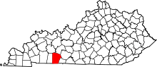 | |
| CDP | ||
| Other unincorporated communities | ||
| Footnotes | ‡This populated place also has portions in an adjacent county or counties | |