Dot, Kentucky
| Dot | |
|---|---|
| Unincorporated community | |
 Dot Location within the state of Kentucky  Dot Dot (the US) | |
| Coordinates: 36°40′40″N 86°57′9″W / 36.67778°N 86.95250°WCoordinates: 36°40′40″N 86°57′9″W / 36.67778°N 86.95250°W | |
| Country | United States |
| State | Kentucky |
| County | Logan |
| Elevation | 522 ft (159 m) |
| Time zone | UTC-5 (Eastern (EST)) |
| • Summer (DST) | UTC-4 (EDT) |
| GNIS feature ID | 491028[1] |
Dot is an unincorporated community located in Logan County, Kentucky, United States.
The origin of the name "Dot" is obscure.[2]
On February 24, 2018, the community was struck by an EF-2 Tornado.[3] One person, an elderly woman, was killed. The tornado was part of a larger weather system that brought several other tornadoes to portions of Arkansas, Missouri, Ohio, and Tennessee, along with major flooding to portions of the Mississippi and Ohio Valleys.[4][5]
References
- ↑ U.S. Geological Survey Geographic Names Information System: Dot, Kentucky
- ↑ Moyer, Armond; Moyer, Winifred (1958). The origins of unusual place-names. Keystone Pub. Associates. p. 141.
- ↑ Louisville, N. W. S. (2018-02-25). "Preliminary information from an ongoing damage survey in southern Logan county: EF-2 with max winds 135 mph. Max width 400 yards. #lmkwx #kywx". @NWSLouisville. Retrieved 2018-02-25.
- ↑ "Severe Storms, Possible Tornadoes Strike the Mid-South; At Least 2 Dead | The Weather Channel". The Weather Channel. Retrieved 2018-02-25.
- ↑ News, A. B. C. (2018-02-25). "4 killed across 3 southern states following reported tornadoes". ABC News. Retrieved 2018-02-25.
Municipalities and communities of Logan County, Kentucky, United States | ||
|---|---|---|
| Cities | 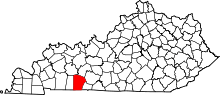 | |
| CDP | ||
| Other unincorporated communities | ||
| Footnotes | ‡This populated place also has portions in an adjacent county or counties | |
This article is issued from
Wikipedia.
The text is licensed under Creative Commons - Attribution - Sharealike.
Additional terms may apply for the media files.