A666 road
| |
|---|---|
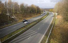 A666 near Farnworth | |
| Major junctions | |
| South end |
Pendlebury 53°30′09″N 2°18′37″W / 53.5025°N 2.3103°W |
|
[[Image:Motorway Left.svg|[ |x30px|link=]] [[Image:Motorway Left.svg|[ |x30px|link=]] [[Image:Motorway Left.svg|[ |x30px|link=]] | |
| North end |
Langho 53°48′31″N 2°26′41″W / 53.8086°N 2.4448°W |
| Location | |
| Primary destinations |
Bolton Blackburn |
| Road network | |

The A666 is a major road in Greater Manchester and Lancashire, England. Known as Manchester Road, Bolton Road, or Blackburn Road, depending on which area it is in, it runs from its junction with the A6 and A580 at the Irlams o' th' Height boundary with Pendlebury near Manchester, through Pendlebury, Clifton, Kearsley, Farnworth, Bolton, Darwen and Blackburn before meeting the A59 at Langho. Along the route are the West Pennine Moors, the Turton and Entwistle reservoir and the Entwistle reservoir forest.
It is sometimes referred to as the Devil's Highway[1] or the Devil's Road because of Biblical associations of its number 666, and its high accident rate on the moors between Egerton and Darwen. Conversely, for a short length from the M61 Kearsley spur and bypassing Farnworth to central Bolton, it is officially called St. Peter's Way.
Road works (speed limit changed from 70mph to 50mph, speed cameras, better safety fencing, banning cyclists from the road, slip road changes) finished at the start of 2000 reduced traffic collisions and crashes by 60%. Before this it was having 26 vehicle collisions and crashes a year with 40 people injured.[1]
See also
References
- 1 2 "No longer the Devil's highway". Bolton Evening News. Newsquest Media Group. 2002-02-13. Archived from the original on 11 September 2014. Retrieved 2008-04-11.
External links
| Wikimedia Commons has media related to A666 road (England). |
A roads in Zone 6 of the Great Britain road numbering scheme | ||
|---|---|---|