A628 road
| |
|---|---|
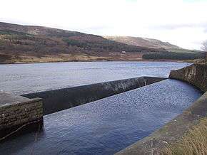 Longdendale: The A628 runs on the far bank of the Rhodeswood Reservoir. A white lorry can just be seen heading east. | |
| Route information | |
| Length | 38.2 mi[1] (61.5 km) |
| Major junctions | |
| West end |
Mottram Moor, Hollingworth (A57 near M67) 53°27′39″N 1°59′46″W / 53.4609°N 1.9961°W |
|
[[Image:Motorway Left.svg|[ |x30px|link=]] | |
| East end |
Pontefract (A639) 53°40′51″N 1°18′48″W / 53.6807°N 1.3133°W |
| Location | |
| Primary destinations | Barnsley |
| Road network | |

The A628 is a major road in the north of England connecting Greater Manchester and South Yorkshire by crossing the Pennine chain of hills by way of the Woodhead Pass through the Peak District National Park. The road's altitude and its exposure to bad weather create problems in winter and the road is sometimes closed due to snow or high winds.
Route
The road starts to the east of Manchester at the end of the M67 motorway and A57 road. It passes through Mottram in Longdendale, Hollingworth and Tintwistle and then through Longdendale and the Peak District National Park to Crowden and Salter's Brook Bridge where the road leaves Derbyshire and enters Barnsley Metropolitan Borough From its summit the road descends through Millhouse Green, Thurlstone, around Penistone before joining the M1 motorway at Junction 37.
From the M1 junction the road passes through Barnsley, Cudworth, Brierley and around Hemsworth (bypassed) to Ackworth Moor Top ending in Pontefract at a junction with the A639 road.
History
The A628 was originally a salt road, as that was a valuable preservative in the 18th century. The route was designed to transport salt from mines in north Cheshire to towns in Yorkshire. Construction of the western section of the road to Saltersbrook in the Longendale valley began in 1732 and the section to the east towards Doncaster opened in 1740.[2] The road was improved and reconstructed as a turnpike road in 1844.[3]
A modern section of the A628 between Barnsley and Pontefract runs on the line of the former Hull and Barnsley Railway.
Traffic
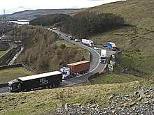
The road's altitude and its exposure to the weather over the Woodhead Pass creates problems in winter[4][5] when it can be closed because of snow or high winds.[6] The high altitude of the pass and its winding, narrow route through the Pennine hills makes travelling difficult, and the road is often closed. The alternative trans-Pennine route is a lengthy detour via the M62, 15 miles to the north. High winds along the pass cause HGVs to overturn or jack-knife, creating obstructions, and ice can make the road "like a skating rink".[7]
In 2015, Highways England proposed a £6bn scheme to build a combined road and rail tunnel under Woodhead, which would be the longest tunnel in Europe. The plans were scaled back to involve a partially tunnelled scheme. Drivers are unimpressed with the slow progress in upgrading the pass, complaining the road "is currently about 30 years behind the times".[7][8]
The Longdendale Bypass has been promoted as a project to remove traffic from the villages of Mottram, Hollingworth and Tintwistle, which lie between the M67 and the Woodhead Pass. The scheme has been perennially controversial. As of 2017, the project has no definitive start date.[9]
Culture
The A628 is mentioned in the 2001 Human League track "The Snake", which suggests it as an alternative route from the M62 or A57 Snake Pass.
See also
References
- ↑ "Directions to Ackworth Rd/A628". Google Maps. Google. Retrieved 13 May 2013.
- ↑ "Old Salt Road via Saltersbrook". Stocksbridge and District Historical Society. Retrieved 16 January 2018.
- ↑ "Doncaster and Salter's Brook Turnpike Road". London Gazette: 4616. 6 November 1844.
- ↑ "A628: Hollingworth - Pontefract". Sabre-roads. Retrieved 27 January 2008.
- ↑ "High winds cause chaos in region". BBC. 18 January 2007. Archived from the original on 29 January 2008. Retrieved 27 January 2008.
- ↑ "A628 Road Watch". Save Swallow's Wood. Archived from the original on 31 October 2007. Retrieved 27 January 2008.
- 1 2 Airey, Tom (16 January 2018). "The north of England's road and rail commuter woes". BBC News. Retrieved 16 January 2018.
- ↑ "A trans-Pennine tunnel, more train lines and cheaper tickets - the 30 year plan to transform transport in the north of England". Manchester Evening News. 16 January 2018. Retrieved 16 January 2018.
- ↑ "Groups' plea for "full Longdendale bypass"". Tameside Reporter. 20 January 2017. Retrieved 16 January 2018.
External links
| Wikimedia Commons has media related to A628 road (England). |
Route map:
A roads in Zone 6 of the Great Britain road numbering scheme | ||
|---|---|---|