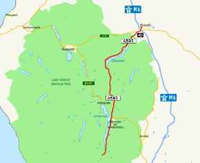
A592 road
| |
|---|---|
 | |
| Route information | |
| Length | 34 mi (55 km) |
| Major junctions | |
| North end | Penrith |
|
[[Image:Motorway Left.svg|[ |x30px|link=]] | |
| South end | Newby Bridge |
| Location | |
| Primary destinations |
Penrith Windermere |
| Road network | |

The A592 road is a major route running north-south through the English Lake District.
The road connects Penrith (54°39′50″N 2°45′09″W / 54.6639°N 2.7524°W), and junction 40 of the M6 motorway), with Staveley at the southern tip of the lake, Windermere, (54°16′02″N 2°58′01″W / 54.2672°N 2.9669°W), which is skirted by the A592 on its eastern bank; the road also follows the northern/western bank of Ullswater. It passes through Glenridding, Patterdale, the town of Windermere (where it crosses the A591 road), Bowness-on-Windermere and Storrs.
The total length is just under 34 miles (55 km), including a short concurrency with the A66 road to the west of the motorway junction.
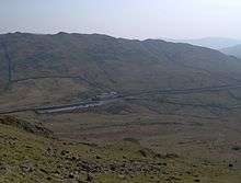
The A592 crosses Kirkstone Pass with a summit at 454 metres (1,490 ft)[1] and is frequently closed in winter.
References
- ↑ "Cumbria Police: A592 Penrith – Windermere". Retrieved 2009-12-21.
Route map:
A roads in Zone 5 of the Great Britain road numbering scheme | ||
|---|---|---|