Interstate 610 (Texas)
| ||||
|---|---|---|---|---|
|
I-610 highlighted in red | ||||
| Route information | ||||
| Maintained by TxDOT | ||||
| Length | 37.972 mi[1] (61.110 km) | |||
| Existed | 1959[1] – present | |||
| Major junctions | ||||
| Beltway around Houston | ||||
|
| ||||
| Highway system | ||||
| ||||
.svg.png)
Interstate 610 (abbreviated I-610) is a freeway that forms a 38-mile-long (61 km) loop around the inner city sector of city of Houston, Texas. Interstate 610, colloquially known as The Loop, Loop 610, The Inner Loop, or just 610, traditionally marks the border between the inner city of Houston ("inside the Loop") and its surrounding areas. It is the inner of the three Houston beltways, the other two being Beltway 8 (Sam Houston Tollway) and State Highway 99 (Grand Parkway), of which various segments are under construction or planning. It is one of four interstate loops not to share its route with another interstate freeway, the others being I-270 in Ohio, I-295 in Florida, and I-485 in North Carolina.
In Houston the area inside the 610 Loop is the urban core. Jeff Balke of the Houston Press wrote that the freeway "is as much a social and philosophical divide as a physical one".[2]
Route description
Major segments of Interstate 610 are known as the North Loop, the South Loop, the East Loop, and the West Loop. The North Loop runs from U.S. Highway 290 to U.S. Highway 90. The East Loop runs from Highway 90 to State Highway 225. The West Loop runs from Highway 290 to the South Post Oak Road spur, and the South Loop runs from South Post Oak Road to Highway 225. Sometimes, a direction name is added as a suffix to denote a more specific part of a portion of the loop and this does not denote the direction of traffic flow.[3] For example:
- North Loop West Freeway[4] refers to the portion of the North Loop between Highway 290 and Interstate 45. North Loop East[5] refers to the portion between Interstate 45 and Highway 90.
- East Loop North Freeway[6] refers to the portion of the East Loop between Highway 90 and Interstate 10. East Loop South refers to the portion between Interstate 10 and State Highway 225.
- South Loop East Freeway[7] refers to the portion of the South Loop between State Highway 225 and State Highway 288. South Loop West[8] refers to the portion between State Highway 288 and the South Post Oak Road spur.
- West Loop South Freeway[9] refers to the portion of the West Loop between the South Post Oak Road spur and Buffalo Bayou (which is just south of Interstate 10). West Loop North[10] refers to the portion between Buffalo Bayou and Highway 290.
Lane configurations
Starting at U.S. Highway 290, moving in a clockwise direction, mainlane counts are as follows:[11]
- 4 lanes each way between U.S. Highway 290 and Interstate 45
- 6 lanes each way between Interstate 45 and Interstate 69/U.S. Highway 59
- 4 lanes each way between Interstate 69/U.S. Highway 59 and Interstate 10
- 5 lanes each way between Interstate 10 and State Highway 225
- 4 lanes each way between State Highway 225 and State Highway 288
- 5 lanes each way between State Highway 288 and South Post Oak Road spur
- 5 lanes northbound, 4 lanes southbound between South Post Oak Road spur and Bissonnet exit
- 5 lanes northbound, 5 lanes southbound between Bissonnet exit and Bellaire Boulevard exit
- 4 lanes northbound, 5 lanes southbound between Bellaire Boulevard exit and Woodway Drive
- 5 lanes each way Woodway Drive and Interstate 10
- 6 lanes each way between Interstate 10 and U.S. Highway 290
History

The concept of building a bypass highway around Houston was first proposed in 1931, but plans did not begin to formalize until 1941. The loop was initially proposed to transport troops and materials around the city. On May 3, Harris County voters approved a bond to build the "Defense Loop". It was officially designated as Loop 137 in 1942, and the North Loop was approved by the Texas Transportation Commission. World War II delayed construction of the Loop until the 1950s.
In July 1953, the city of Houston asked the Texas Transportation Commission to include 2 new sections of Loop 137 (the West Loop and the South Loop) as part of the state's highway system. It was initially rejected, but in October 1954, the North Loop was upgraded to a freeway, and the West and South Loops were approved as freeways.
When the Interstate Highway system was authorized in 1956, the then C-shaped Loop 137 (now designated Interstate 610) was adopted into the plan. The East Loop would not be approved until 1960. That segment was finished in 1973 with the opening of the Sidney Sherman Bridge over the Houston Ship Channel.
Construction on the North Loop began in 1950. Construction was sporadic throughout the 1950s and 1960s. It was completed in 1976 with the interchange that connects Loop 610 to Interstate 10 east of Houston.
In the early 1990s, TxDOT proposed a widening project for the West Loop, which at the time was the busiest freeway in Houston. One of the proposals was for a dual-dual freeway with a total of 24 lanes in some places, which would have made it the widest freeway in the world. Amid vocal opposition and little apparent support, the plans for expansion were cancelled.[12]
In the late 1990s, the need to repave and reconstruct portions of the West Loop became evident. The reconstruction project was approved, but only as a "no-capacity-added" project; only safety and structural improvements could be made.[12][13] However, some Houston residents have noted that merging lanes and exit ramps are particularly long and in effect, serve as additional lanes.[14]
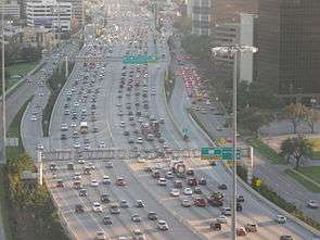
As of 2014, the segment of the West Loop from the Katy Freeway to the Southwest Freeway is ranked by TxDOT as the most congested roadway in the state, based on annual hours of delay per mile.[15]
Parts of I-610 flooded during Hurricane Harvey in 2017.[16]
Exit list
The entire highway is in Harris County.
| Location | mi | km | Exit | Destinations | Notes |
|---|---|---|---|---|---|
| Houston | 1A | Eastbound (counterclockwise) exit and westbound (clockwise) entrance | |||
| 1B | Fannin Street | ||||
| 1C | Kirby Drive | ||||
| 2 | |||||
| 3 | Stella Link Road | ||||
| 4A | South Braeswood Boulevard / North Braeswood Boulevard | ||||
| 4B | South Post Oak Road | Signed direction switches between east–west and north–south; left exit westbound | |||
| 5A | Beechnut Street | No direct northbound (clockwise) exit (signed at exit 4A) | |||
| Bellaire | 5B | Evergreen Street | No direct southbound (counterclockwise) exit (signed at exit 6) | ||
| 6 | Bellaire Boulevard | ||||
| 7 | Bissonnet Street / Fournace Place | No direct northbound (clockwise) exit (signed at exit 6), no southbound (counterclockwise) exit | |||
| Houston | 7 | Westpark Drive | Southbound (counterclockwise) entrance only | ||
| 8A | I-69/US 59 exit 123; stack interchange. | ||||
| 8B | Hidalgo Street / Richmond Avenue | Southbound (counterclockwise) exit and northbound (clockwise) entrance | |||
| 8C | |||||
| 9 | San Felipe Road / Post Oak Boulevard | Signed as exits 9A (San Felipe Road) and 9B (Post Oak Boulevard) southbound (counterclockwise); no southbound (counterclockwise) exit to Post Oak | |||
| 10 | Woodway Drive / Memorial Drive | Two identical exits southbound (counterclockwise): 10B before the merge from I-10 and 10A after | |||
| 11 | I-10 exit 763 | ||||
| 12 | Katy Road | Southbound exit only | |||
| 13C | West 18th Street / Hempstead Road | northbound (clockwise) exit and southbound (counterclockwise) entrance | |||
| 13A | Redesigned tri-stack interchange | ||||
| 13B | West T.C. Jester Boulevard / East T.C. Jester Boulevard | ||||
| 14 | Access to Memorial Hermann Northwest Hospital | ||||
| 15 | Access to Northwest Health Center | ||||
| 16 | Yale Street / North Main Street | Signed as exits 16A (Yale Street) and 16B (North Main Street) eastbound (clockwise) | |||
| 17A | Airline Drive | Eastbound (clockwise) exit and westbound (counterclockwise) entrance | |||
| 17 | Signed as exits 17B (north) and 17C (south); left exits to 45 north eastbound & 45 south westbound; I-45 exit 51 | ||||
| 18 | Irvington Boulevard / Fulton Street | ||||
| 19A | Hardy Street / Jensen Drive | Eastbound (clockwise) exit and westbound (counterclockwise) entrance | |||
| 19B | |||||
| 20 | I-69/US 59 exit 134 northbound, 135A-B southbound; signed as exits 20A (north) & 20B (south) westbound (counterclockwise) | ||||
| 20C | Hirsch Road | no direct eastbound (clockwise) exit (signed at exit 21) | |||
| 21 | Access to Lyndon B. Johnson General Hospital | ||||
| 22 | Homestead Road / Kelley Street | ||||
| 23A | Kirkpatrick Boulevard | ||||
| 23B | North Wayside Drive / Liberty Road | ||||
| 24 | Signed as exits 24A (US 90 Bus.) and 24B (Wallisville Road) northbound (counterclockwise) | ||||
| 25 | Gellhorn Drive | Southbound (clockwise) exit and northbound (counterclockwise) entrance | |||
| 26A | I-10 exit 775A; no access from I-610 south (clockwise) to US 90 east or US 90 west to I-610 north (counterclockwise) | ||||
| 26B | Market Street | Northbound (counterclockwise) exit and southbound (clockwise) entrance | |||
| 27 | Turning Basin Drive | No northbound (counterclockwise) exit | |||
| 28 | Clinton Drive | ||||
| 29 | Port of Houston Main Entrance | ||||
| 30A | Manchester Street | Southbound (clockwise) exit and northbound (counterclockwise) entrance | |||
| 30B-C | Signed as exits 30B (east) and 30C (west) | ||||
| 30D | Lawndale Avenue | No direct southbound (clockwise) exit (signed at exit 30C) | |||
| 31 | Broadway Boulevard | ||||
| 32 | Signed as exits 32A (I-45 south) and 32B (I-45 north / SH 35 south); I-45 exit 40 | ||||
| 33 | Woodridge Drive / Telephone Road | ||||
| 34A | South Wayside Drive / Long Drive | ||||
| 35 | Crestmont Street / M.L. King Boulevard / Mykawa Road | ||||
| 36A | Calais Road / Holmes Road / M.L. King Boulevard | ||||
| 36B | no direct westbound (clockwise) exit (signed at exit 36A) | ||||
| 37 | Scott Street | ||||
| 38A | Signed as exits 38A (north) and 38C (south) eastbound (counterclockwise) | ||||
| 1.000 mi = 1.609 km; 1.000 km = 0.621 mi | |||||
See also
References
- 1 2 Transportation Planning and Programming Division (n.d.). "Interstate Highway No. 610". Highway Designation Files. Texas Department of Transportation.
- ↑ Balke, Jeff. "10 Things You Say That Make You a Houstonian." Houston Press. Tuesday October 21, 2014. p. 2 (Archive). Retrieved on October 24, 2014.
- ↑ "Clearing up confusion of multiple highway names". Houston Chronicle. November 20, 2005.
- ↑ Google (September 7, 2006). "North Loop Fwy W" (Map). Google Maps. Google. Retrieved September 7, 2006.
- ↑ Google (September 7, 2006). "North Loop Fwy E" (Map). Google Maps. Google. Retrieved September 7, 2006.
- ↑ Google (September 7, 2006). "East Loop Fwy N" (Map). Google Maps. Google. Retrieved September 7, 2006.
- ↑ Google (September 7, 2006). "South Loop Fwy E" (Map). Google Maps. Google. Retrieved September 7, 2006.
- ↑ Google (September 7, 2006). "South Loop Fwy W" (Map). Google Maps. Google. Retrieved September 7, 2006.
- ↑ Google (September 7, 2006). "Interstate 610 (Texas)" (Map). Google Maps. Google. Retrieved September 7, 2006.
- ↑ Google (September 7, 2006). "West Loop Fwy N" (Map). Google Maps. Google. Retrieved September 7, 2006.
- ↑ Slotboom, Erik. "Notes and Index" (PDF). Houston Freeways. Self-published.
- 1 2 Slotboom, Erik. "The Loop, Interstate 610" (PDF). Houston Freeways. Self-published. Retrieved December 15, 2006.
- ↑ Sallee, Rad (December 3, 2006). "Reader worries drivers will take turn for the worse". Houston Chronicle. Retrieved December 15, 2006.
- ↑ Sallee, Rad (November 26, 2006). "More buildings checked for 'stray' Metro current". Houston Chronicle. Retrieved December 15, 2006.
- ↑ "100 Congested Roadways". Texas Department of Transportation. Retrieved December 8, 2014.
- ↑ Taylor, Alan. "The Unprecedented Flooding in Houston, in Photos". The Atlantic. Retrieved 2017-09-27.
External links
| Wikimedia Commons has media related to: |
Route map: