15 kV AC railway electrification

A pylon of a single phase AC 110 kV-powerline near Bartholomä in Germany. Lines of these type are used in Germany to supply electric railways with single phase AC at 16.7 hertz. In the substations of the railway, transformers are used to step it down to 15 kV.

The 15 kV, 16.7 Hz AC railway electrification system is used in Germany, Austria, Switzerland, Sweden and Norway. The high voltage enables high power transmission with the lower frequency reducing the losses of the traction motors that were available at the beginning of the 20th century. Railway electrification in late 20th century tends to use 25 kV, 50 Hz AC systems which has become the preferred standard for new railway electrifications but extensions of the existing 15 kV networks are not completely unlikely. In particular, the Gotthard Base Tunnel (opened on 1 June 2016) still uses 15 kV, 16.7 Hz electrification.

Due to high conversion costs, it is unlikely that existing 15 kV, 16.7 Hz systems will be converted to 25 kV, 50 Hz despite the fact that this would reduce the weight of the on-board step-down transformers to one third that of the present devices.

History

The first electrified railways used series-wound DC motors, first at 600 V and then 1,500 V. Areas with 3 kV DC catenaries (primarily in Eastern Europe) used two 1,500 V DC motors in series. But even at 3 kV, the current needed to power a heavy train (particularly in rural and mountainous areas) can be excessive. Although increasing the transmission voltage decreases the current and associated resistive losses for a given power, insulation limits make higher voltage traction motors impractical. Transformers on each locomotive are thus required to step high transmission voltages down to practical motor operating voltages. Before the development of suitable ways to efficiently transform DC currents through power electronics, efficient transformers strictly required alternating current (AC); thus high voltage electrified railways adopted AC along with the electric power distribution system (see War of Currents).

The 50 Hz (60 Hz in North America) AC grid was already established at the beginning of the 20th century. Although series-wound motors can in principle run on AC as well as DC (the reason they are also known as universal motors) large series-wound traction motors had problems with such high frequencies. High inductive reactance of the motor windings caused commutator flashover problems and the non-laminated magnetic pole-pieces originally designed for DC exhibited excessive eddy current losses. Using a lower AC frequency alleviated both problems.

In the German-speaking countries, high-voltage electrification began at 16 23 hertz, exactly one third of the national power grid frequency of 50 Hz. This facilitated the operation of rotary converters from the grid frequency and allowed dedicated railway power generators to operate at the same shaft speed as a standard 50 Hz generator by reducing the number of poles by a factor of three. For example, a generator turning at 1,000 rpm would be wound with two poles rather than six.

Separate plants supply railway power in Austria, Switzerland and Germany, except for Mecklenburg-Western Pomerania and Saxony-Anhalt; converters powered by the grid supply railway power in those two German states plus Sweden and Norway. Norway also has two hydro-electric power plants dedicated for railway power with 16 23 hertz output.

The first generators were synchronous AC generators or synchronous transformers; however, with the introduction of modern double fed induction generators, the control current induced an undesired DC component, leading to pole overheating problems. This was solved by shifting the frequency slightly away from exactly ⅓ the grid frequency; 16.7 hertz was arbitrarily chosen to remain within the tolerance of existing traction motors. Austria, Switzerland and Southern Germany switched their power plants to 16.7 Hz on 16 October 1995 at 12:00 CET.[1][2] Note that regional electrified sections run by synchronous generators keep their frequency of 16 23 Hz just as Sweden and Norway still run their railway networks at 16 23 Hz throughout.

One of the disadvantages of 16.7 Hz locomotives as compared to 50 Hz or 60 Hz locomotives is the heavier transformer required to reduce the overhead line voltage to that used by the motors and their speed control gear. Low frequency transformers need to have heavier magnetic cores and larger windings for the same level of power conversion. (See effect of frequency on the design of transformers.) The heavier transformers also lead to higher axle loads than for those of a higher frequency. This, in turn, leads to increased track wear and increases the need for more frequent track maintenance. The Czech Railways encountered the problem of the reduced power handling of lower frequency transformers when they rebuilt some 25 kV AC, 50 Hz locomotives (series 340) to operate on 15 kV AC, 16.7 Hz lines. As a result of using the same transformer cores (originally designed for 50 Hz) at the lower frequency, the transformers had to be de-rated to one third of their original power handling capability, thereby reducing the available tractive effort by the same amount (to around 1,000 kW).

These drawbacks, plus the need for a separate supply infrastructure and the lack of any technical advantages with modern motors and controllers has limited the use of 16 23 Hz and 16.7 Hz beyond the original five countries. Most other countries electrified their railways at the utility frequency of 50/60 Hz. Newer European electrification is mostly 25 kV AC at 50 Hz (primarily in Eastern Europe). Conversion to this voltage/frequency requires higher voltage insulators and greater clearance between lines and bridges and other structures. This is now standard for new overhead lines as well as for modernizing old installations.

Simple European standardization with an alignment of voltage/frequency across Europe is not necessarily cost-effective since trans-border traction is more limited by the differing national standards in other areas. To equip an electric locomotive with a transformer for two or more input voltages is cheap compared to the cost of installing multiple train protection systems and to run them through the approval procedure to get access to the railway network in other countries. However, some new high-speed lines to neighbouring countries are already intended to be built to 25 kV (e.g. in Austria to Eastern Europe). Newer locomotives are always built with asynchronous motor control systems that have no problem with a range of input frequencies including DC. However the Deutsche Bahn train operator does still use older models from the standard electric locomotive series - even though some are now as much as 50 years old. As soon as these obsolescent models are decommissioned, it will be easier to standardise, but this may take a few decades to happen. Meanwhile, the Deutsche Bahn tends to order train sets that are capable of running multiple electrification systems.

Distribution networks

single-phase (two-wire) lines coming out of a converter plant

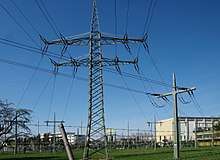
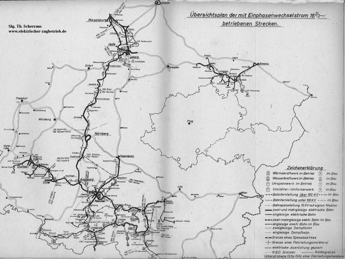
In Germany (except Mecklenburg-Western Pomerania and Saxony-Anhalt), Austria and Switzerland, there is a separate single-phase power distribution grid for railway power at 16.7 Hz; the voltage is 110 kV in Germany and Austria and 132 kV in Switzerland. This system is called the centralized railway energy supply. A separate single-phase power distribution grid makes the recuperation of energy during braking extremely easy in comparison with 25 kV 50 Hz system tied to 3 phase distribution grid.

In Sweden, Norway, Mecklenburg-Western Pomerania and Saxony-Anhalt, the power is taken directly from the three-phase grid (110 kV at 50 Hz), converted to low frequency single phase and fed into the overhead line. This system is called the decentralized (i.e. local) railway energy supply.

Generation and conversion

The centralized system is supplied by special power plants that generate 110 kV (or 132 kV in the Swiss system) AC at 16.7 Hz and by rotary converters or AC/AC converters that are supplied from the national power grid (e.g. 110 kV, 50 Hz), they convert it to 55-0-55 kV (or 66-0-66 kV) AC at 16.7 Hz. The 0 V point is connected to earth through an inductance so that each conductor of the single phase AC power line has a voltage of 55 kV (or 66 kV) with respect to earth potential. This is similar to split-phase electric power systems and results in a balanced line transmission. The inductance through which the earthing is done is designed to limit earth currents in cases of faults on the line. At the transformer substations, the voltage is transformed from 110 kV (or 132 kV) AC to 15 kV AC and the energy is fed into the overhead line.

Asynchronous converters

The frequency of 16.7 Hz depends on the necessity to avoid synchronism in parts of the rotary machine, which consists principally of a three phase asynchronous motor and a single phase synchronous generator. Since synchronism sets in at a frequency of 16 23 Hz (according to the technical details) in the single phase system, the frequency of the centralized system was set to 16.7 Hz.

Power plants providing 110 kV, 16.7 Hz, are either dedicated to generating this specific single phase AC or have special generators for the purpose, such as the Neckarwestheim nuclear power plant or the Walchensee hydroelectric power station.

Synchronous converters

The power for the decentralized system is taken directly from the national power grid and directly transformed and converted into 15 kV, 16 23 Hz by synchronous-synchronous-converters or static converters. Both systems need additional transformers. The converters consist of a three-phase synchronous motor and a single-phase synchronous generator. The decentralized system in the north-east of Germany was established by the Deutsche Reichsbahn in the 1980s, because there was no centralized system available in these areas.

Facilities for 15 kV AC railway electrification in Germany, Austria and Switzerland

Germany, Austria and Switzerland operate the largest interconnected 15 kV AC system with central generation, and central and local converter plants.

Germany

Substations

In these facilities electricity is transformed down from 110 kV-level of DB to 15 kV. There is no conversion or generation of power.

Facility Coordinates
Aalen48°49′20″N 10°02′31″E / 48.82222°N 10.04194°E / 48.82222; 10.04194 (Unterwerk Aalen)
Adelsheim49°24′57″N 9°24′17″E / 49.41583°N 9.40472°E / 49.41583; 9.40472 (Unterwerk Adelsheim)
Almstedt52°01′53″N 9°56′26″E / 52.03139°N 9.94056°E / 52.03139; 9.94056 (Unterwerk Almstedt)
Amstetten48°34′08″N 9°52′37″E / 48.56889°N 9.87694°E / 48.56889; 9.87694 (Unterwerk Amstetten)
Appenweier48°32′37″N 7°58′23″E / 48.54361°N 7.97306°E / 48.54361; 7.97306 (Unterwerk Appenweier)
Aschaffenburg49°59′08″N 9°05′33″E / 49.98556°N 9.09250°E / 49.98556; 9.09250 (Unterwerk Aschaffenburg)
Aubing48°09′08″N 11°26′40″E / 48.15222°N 11.44444°E / 48.15222; 11.44444 (Unterwerk Aubing)
Augsburg48°23′54″N 10°52′0″E / 48.39833°N 10.86667°E / 48.39833; 10.86667 (Unterwerk Augsburg)
Bachstedt (planned)51°03′18″N 11°11′32″E / 51.05500°N 11.19222°E / 51.05500; 11.19222 (Unterwerk Bachstedt (planned))
Baden-Baden48°44′03″N 8°08′49″E / 48.73417°N 8.14694°E / 48.73417; 8.14694 (Unterwerk Baden-Baden)
Bad Reichenhall47°44′51″N 12°54′09″E / 47.74750°N 12.90250°E / 47.74750; 12.90250 (Unterwerk Bad Reichenhall)
Barnstorf52°42′26″N 8°30′40″E / 52.70722°N 8.51111°E / 52.70722; 8.51111 (Unterwerk Barnsdorf)
Bebra50°58′32″N 9°47′23″E / 50.97556°N 9.78972°E / 50.97556; 9.78972 (Unterwerk Bebra)
Bengel50°0′34″N 7°03′23″E / 50.00944°N 7.05639°E / 50.00944; 7.05639 (Unterwerk Bengel)
Berlin-Schönefeld52°23′39″N 13°31′03″E / 52.39417°N 13.51750°E / 52.39417; 13.51750 (Unterwerk Berlin-Schönefeld)
Biblis49°41′03″N 8°26′39″E / 49.68417°N 8.44417°E / 49.68417; 8.44417 (Unterwerk Biblis)
Bingen49°57′16″N 7°56′54″E / 49.95444°N 7.94833°E / 49.95444; 7.94833 (Unterwerk Bingen)
Böhla51°14′08″N 13°32′44″E / 51.23556°N 13.54556°E / 51.23556; 13.54556 (Unterwerk Böhla)
Boizenburg53°23′29″N 10°43′58″E / 53.39139°N 10.73278°E / 53.39139; 10.73278 (Unterwerk Boizenburg)
Borken ( part of converter)51°03′07″N 9°17′01″E / 51.05194°N 9.28361°E / 51.05194; 9.28361 (Unterwerk Borken ( part of converter))
Borne52°06′40″N 12°32′28″E / 52.11111°N 12.54111°E / 52.11111; 12.54111 (Unterwerk Borne)
Braunschweig52°16′09″N 10°38′24″E / 52.26917°N 10.64000°E / 52.26917; 10.64000 (Unterwerk Braunschweig)
Buchholz53°19′20″N 9°51′44″E / 53.32222°N 9.86222°E / 53.32222; 9.86222 (Unterwerk Buchholz)
Burgdorf47°03′44″N 7°36′41″E / 47.06222°N 7.61139°E / 47.06222; 7.61139 (Unterwerk Burgdorf)
Burgweinting48°58′53″N 12°09′13″E / 48.98139°N 12.15361°E / 48.98139; 12.15361 (Unterwerk Burgweinting)
Chemnitz ( part of converter)50°51′44″N 12°56′21″E / 50.86222°N 12.93917°E / 50.86222; 12.93917 (Chemnitz ( part of converter))
Datteln51°37′43″N 7°20′03″E / 51.62861°N 7.33417°E / 51.62861; 7.33417 (Unterwerk Datteln)
Denkendorf48°56′19″N 11°27′19″E / 48.93861°N 11.45528°E / 48.93861; 11.45528 (Unterwerk Denkendorf)
Donauwörth48°42′58″N 10°45′43″E / 48.71611°N 10.76194°E / 48.71611; 10.76194 (Unterwerk Donauwörth)
Dörstewitz (planned)51°23′35″N 11°54′16″E / 51.39306°N 11.90444°E / 51.39306; 11.90444 (Unterwerk Dörstewitz (planned))
Dortmund51°30′38″N 7°24′03″E / 51.51056°N 7.40083°E / 51.51056; 7.40083 (Unterwerk Dortmund)
Dortmund-Scharnhorst51°32′14″N 7°31′56″E / 51.53722°N 7.53222°E / 51.53722; 7.53222 (Unterwerk Dortmund-Scharnhorst)
Dresden ( part of converter)50°59′40″N 13°50′06″E / 50.99444°N 13.83500°E / 50.99444; 13.83500 (Unterwerk Dresden ( part of converter))
Duisburg51°24′45″N 6°47′33″E / 51.41250°N 6.79250°E / 51.41250; 6.79250 (Unterwerk Duisburg)
Düsseldorf51°13′18″N 6°50′11″E / 51.22167°N 6.83639°E / 51.22167; 6.83639 (Unterwerk Düsseldorf)
Ebensfeld50°05′0″N 10°57′41″E / 50.08333°N 10.96139°E / 50.08333; 10.96139 (Unterwerk Ebensfeld)
Eggolsheim49°45′10″N 11°03′27″E / 49.75278°N 11.05750°E / 49.75278; 11.05750 (Unterwerk Eggolsheim)
Eichenberg51°22′34″N 9°55′31″E / 51.37611°N 9.92528°E / 51.37611; 9.92528 (Unterwerk Eichenberg)
Eilenburg51°26′48″N 12°37′08″E / 51.44667°N 12.61889°E / 51.44667; 12.61889 (Unterwerk Eilenburg)
Eischleben (planned)50°53′02″N 10°58′55″E / 50.88389°N 10.98194°E / 50.88389; 10.98194 (Unterwerk Eischleben (planned))
Eisenach50°57′51″N 10°22′19″E / 50.96417°N 10.37194°E / 50.96417; 10.37194 (Unterwerk Eisenach)
Elmshorn53°45′45″N 9°39′17″E / 53.76250°N 9.65472°E / 53.76250; 9.65472 (Unterwerk Elmshorn)
Elsfleth53°16′52″N 8°28′26″E / 53.28111°N 8.47389°E / 53.28111; 8.47389 (Unterwerk Elsfleth)
Emden53°21′30″N 7°13′11″E / 53.35833°N 7.21972°E / 53.35833; 7.21972 (Unterwerk Emden)
Emskirchen49°33′30″N 10°41′43″E / 49.55833°N 10.69528°E / 49.55833; 10.69528 (Unterwerk Emskirchen)
Essen51°27′24″N 7°01′39″E / 51.45667°N 7.02750°E / 51.45667; 7.02750 (Unterwerk Essen)
Eutingen48°28′47″N 8°46′44″E / 48.47972°N 8.77889°E / 48.47972; 8.77889 (Unterwerk Eutingen)
Eystrup52°47′32″N 9°13′45″E / 52.79222°N 9.22917°E / 52.79222; 9.22917 (Unterwerk Eystrup)
Fallersleben52°25′16″N 10°40′30″E / 52.42111°N 10.67500°E / 52.42111; 10.67500 (Unterwerk Fallersleben)
Finnentrop51°10′03″N 7°58′01″E / 51.16750°N 7.96694°E / 51.16750; 7.96694 (Unterwerk Finnentrop)
Flieden50°25′08″N 9°34′18″E / 50.41889°N 9.57167°E / 50.41889; 9.57167 (Unterwerk Fliedern)
Flörsheim50°0′17″N 8°24′54″E / 50.00472°N 8.41500°E / 50.00472; 8.41500 (Unterwerk Flörsheim)
Freiburg47°58′52″N 7°49′41″E / 47.98111°N 7.82806°E / 47.98111; 7.82806 (Unterwerk Freiburg)
Friedberg50°19′28″N 8°46′25″E / 50.32444°N 8.77361°E / 50.32444; 8.77361 (Unterwerk Friedberg)
Fronhausen50°41′55″N 8°41′53″E / 50.69861°N 8.69806°E / 50.69861; 8.69806 (Unterwerk Fronhausen)
Fulda50°32′40″N 9°41′28″E / 50.54444°N 9.69111°E / 50.54444; 9.69111 (Unterwerk Fulda)
Gabelbach48°22′45″N 10°33′35″E / 48.37917°N 10.55972°E / 48.37917; 10.55972 (Unterwerk Gabelbach)
Garssen52°40′30″N 10°07′44″E / 52.67500°N 10.12889°E / 52.67500; 10.12889 (Unterwerk Garssen)
Geisenbrunn48°06′29″N 11°19′51″E / 48.10806°N 11.33083°E / 48.10806; 11.33083 (Unterwerk Geisenbrunn)
Geltendorf48°06′21″N 11°01′48″E / 48.10583°N 11.03000°E / 48.10583; 11.03000 (Unterwerk Geltendorf)
Gemünden50°03′35″N 9°40′38″E / 50.05972°N 9.67722°E / 50.05972; 9.67722 (Unterwerk Gemünden)
Genshagener Heide52°20′05″N 13°16′38″E / 52.33472°N 13.27722°E / 52.33472; 13.27722 (Unterwerk Genshager Heide)
Gleidingen52°16′01″N 9°50′06″E / 52.26694°N 9.83500°E / 52.26694; 9.83500 (Unterwerk Gleidingen)
Golm52°24′10″N 12°58′08″E / 52.40278°N 12.96889°E / 52.40278; 12.96889 (Unterwerk Golm)
Gössnitz (old)50°52′36″N 12°25′10″E / 50.87667°N 12.41944°E / 50.87667; 12.41944 (Unterwerk Gössnitz)
Gössnitz (new)50°54′07″N 12°25′59″E / 50.90194°N 12.43306°E / 50.90194; 12.43306 (Unterwerk Gössnitz)
Grafing48°02′53″N 11°56′12″E / 48.04806°N 11.93667°E / 48.04806; 11.93667 (Unterwerk Gössnitz)
Grönhart48°59′29″N 10°55′48″E / 48.99139°N 10.93000°E / 48.99139; 10.93000 (Unterwerk Grafing)
Grossheringen51°06′22″N 11°39′19″E / 51.10611°N 11.65528°E / 51.10611; 11.65528 (Unterwerk Grossheringen)
Grosskorbetha51°15′12″N 12°01′14″E / 51.25333°N 12.02056°E / 51.25333; 12.02056 (Unterwerk Grosskorbetha)
Grünauer Kreuz ( switching post)52°25′31″N 13°33′42″E / 52.42528°N 13.56167°E / 52.42528; 13.56167 (Unterwerk Grünauer Kreuz ( switching post))
Güsen52°20′07″N 11°58′42″E / 52.33528°N 11.97833°E / 52.33528; 11.97833 (Unterwerk Gütha)
Hagen51°24′32″N 7°27′43″E / 51.40889°N 7.46194°E / 51.40889; 7.46194 (Unterwerk Hagen)
Hahn (planned)53°17′42″N 8°09′52″E / 53.29500°N 8.16444°E / 53.29500; 8.16444 (Unterwerk Hahn (planned))
Halbe (fed from 15 kV line from Neuhof)52°07′00″N 13°41′31″E / 52.11667°N 13.69194°E / 52.11667; 13.69194 (Unterwerk Halbe)
Haltingen47°36′19″N 7°36′40″E / 47.60528°N 7.61111°E / 47.60528; 7.61111 (Unterwerk Haltingen)
Hamburg-Harburg ( part of converter)53°26′57″N 10°00′02″E / 53.44917°N 10.00056°E / 53.44917; 10.00056 (Unterwerk Hamburg-Harburg ( part of converter))
Hameln52°08′26″N 9°26′43″E / 52.14056°N 9.44528°E / 52.14056; 9.44528 (Unterwerk Hameln)
Haren52°47′02″N 7°18′04″E / 52.78389°N 7.30111°E / 52.78389; 7.30111 (Unterwerk Haren)
Heeren52°34′28″N 11°52′05″E / 52.57444°N 11.86806°E / 52.57444; 11.86806 (Unterwerk Heeren)
Herbolzheim48°13′58″N 7°46′09″E / 48.23278°N 7.76917°E / 48.23278; 7.76917 (Unterwerk Herbolzheim)
Herchen50°46′11″N 7°31′19″E / 50.76972°N 7.52194°E / 50.76972; 7.52194 (Unterwerk Herchen)
Hessental49°05′58″N 9°46′36″E / 49.09944°N 9.77667°E / 49.09944; 9.77667 (Unterwerk Hessental)
Höchst50°06′12″N 8°33′28″E / 50.10333°N 8.55778°E / 50.10333; 8.55778 (Unterwerk Höchst)
Holzkirchen47°53′0″N 11°41′56″E / 47.88333°N 11.69889°E / 47.88333; 11.69889 (Unterwerk Holzkirchen)
Ihringshausen51°21′07″N 9°32′14″E / 51.35194°N 9.53722°E / 51.35194; 9.53722 (Unterwerk Ihringshausen)
Ilmenau-Wolfsberg (planned)50°41′17″N 10°59′54″E / 50.68806°N 10.99833°E / 50.68806; 10.99833 (Unterwerk Ilmenau-Wolfsberg (planned))
Ingolstadt48°46′48″N 11°25′34″E / 48.78000°N 11.42611°E / 48.78000; 11.42611 (Unterwerk Ingolstadt)
Jübek ( part of converter)54°33′25″N 9°24′35″E / 54.55694°N 9.40972°E / 54.55694; 9.40972 (Unterwerk Jübek ( part of converter))
Kaiserslautern49°26′16″N 7°42′19″E / 49.43778°N 7.70528°E / 49.43778; 7.70528 (Unterwerk Kaiserslautern)
Karow52°36′29″N 13°27′30″E / 52.60806°N 13.45833°E / 52.60806; 13.45833 (Unterwerk Karow)
Karthaus49°42′28″N 6°35′28″E / 49.70778°N 6.59111°E / 49.70778; 6.59111 (Unterwerk Karthaus)
Kirchheim50°52′40″N 9°35′13″E / 50.87778°N 9.58694°E / 50.87778; 9.58694 (Unterwerk Kirchheim)
Kirchmöser52°22′55″N 12°24′36″E / 52.38194°N 12.41000°E / 52.38194; 12.41000 (Unterwerk Kirchmöser)
Klebitz51°56′32″N 12°50′12″E / 51.94222°N 12.83667°E / 51.94222; 12.83667 (Unterwerk Klebitz)
Koblenz50°23′12″N 7°33′52″E / 50.38667°N 7.56444°E / 50.38667; 7.56444 (Unterwerk Koblenz)
Köln ( part of converter)50°54′14″N 7°02′55″E / 50.90389°N 7.04861°E / 50.90389; 7.04861 (Unterwerk Köln ( part of converter))
Köln-Mülheim50°58′21″N 7°01′07″E / 50.97250°N 7.01861°E / 50.97250; 7.01861 (Unterwerk Köln-Mülheim)
Körle51°10′51″N 9°31′48″E / 51.18083°N 9.53000°E / 51.18083; 9.53000 (Unterwerk Körle)
Kreiensen51°50′54″N 9°58′11″E / 51.84833°N 9.96972°E / 51.84833; 9.96972 (Unterwerk Kreiensen)
Kyhna51°30′42″N 12°16′50″E / 51.51167°N 12.28056°E / 51.51167; 12.28056 (Unterwerk Kyhna)
Landshut48°32′48″N 12°06′31″E / 48.54667°N 12.10861°E / 48.54667; 12.10861 (Unterwerk Landshut)
Leer53°12′48″N 7°27′53″E / 53.21333°N 7.46472°E / 53.21333; 7.46472 (Unterwerk Leer)
Lehrte ( part of converter)52°22′54″N 9°57′20″E / 52.38167°N 9.95556°E / 52.38167; 9.95556 (Unterwerk Lehrte ( part of converter))
Leipzig-Wahren51°22′55″N 12°18′47″E / 51.38194°N 12.31306°E / 51.38194; 12.31306 (Unterwerk Leipzig-Wahren)
Leonberg48°47′35″N 8°58′28″E / 48.79306°N 8.97444°E / 48.79306; 8.97444 (Unterwerk Aalen)
Limburg50°22′45″N 8°05′59″E / 50.37917°N 8.09972°E / 50.37917; 8.09972 (Unterwerk Limburg)
Löhne52°11′42″N 8°42′35″E / 52.19500°N 8.70972°E / 52.19500; 8.70972 (Unterwerk Löhne)
Lüneburg53°16′01″N 10°24′42″E / 53.26694°N 10.41167°E / 53.26694; 10.41167 (Unterwerk Lüneburg)
Magdeburg52°09′12″N 11°39′35″E / 52.15333°N 11.65972°E / 52.15333; 11.65972 (Unterwerk Magdeburg)
Mainbernheim49°42′0″N 10°12′39″E / 49.70000°N 10.21083°E / 49.70000; 10.21083 (Unterwerk Mainbernheim)
Mannheim49°26′27″N 8°33′43″E / 49.44083°N 8.56194°E / 49.44083; 8.56194 (Unterwerk Mannheim)
Markt Bibart49°38′48″N 10°25′24″E / 49.64667°N 10.42333°E / 49.64667; 10.42333 (Unterwerk Markt Bibart)
Markt Schwaben48°11′06″N 11°50′59″E / 48.18500°N 11.84972°E / 48.18500; 11.84972 (Unterwerk Markt Schwaben)
Marl ( part of converter)51°39′42″N 7°10′45″E / 51.66167°N 7.17917°E / 51.66167; 7.17917 (Unterwerk Marl ( part of converter))
Meckesheim49°19′45″N 8°48′19″E / 49.32917°N 8.80528°E / 49.32917; 8.80528 (Unterwerk Meckesheim)
Mehrhoog51°44′55″N 6°29′57″E / 51.74861°N 6.49917°E / 51.74861; 6.49917 (Unterwerk Mehrhoog)
Montabaur50°26′43″N 7°49′13″E / 50.44528°N 7.82028°E / 50.44528; 7.82028 (Unterwerk Montabeur)
Mörlach49°11′57″N 11°14′24″E / 49.19917°N 11.24000°E / 49.19917; 11.24000 (Unterwerk Mörlach)
Mottgers50°16′43″N 9°39′21″E / 50.27861°N 9.65583°E / 50.27861; 9.65583 (Unterwerk Mottgers)
Mühlacker48°57′06″N 8°50′15″E / 48.95167°N 8.83750°E / 48.95167; 8.83750 (Unterwerk Mühlacker)
Mühlanger51°51′02″N 12°45′54″E / 51.85056°N 12.76500°E / 51.85056; 12.76500 (Unterwerk Mühlanger)
Muldenstein51°39′31″N 12°21′01″E / 51.65861°N 12.35028°E / 51.65861; 12.35028 (Unterwerk Muldenstein)
Müllheim47°48′20″N 7°35′44″E / 47.80556°N 7.59556°E / 47.80556; 7.59556 (Unterwerk Müllheim)
München-Freimann48°11′56″N 11°36′30″E / 48.19889°N 11.60833°E / 48.19889; 11.60833 (Unterwerk München-Freimann)
München-Ost48°08′13″N 11°39′02″E / 48.13694°N 11.65056°E / 48.13694; 11.65056 (Unterwerk München-Ost)
Münster51°55′25″N 7°38′05″E / 51.92361°N 7.63472°E / 51.92361; 7.63472 (Unterwerk Münster)
Murnau47°41′19″N 11°11′33″E / 47.68861°N 11.19250°E / 47.68861; 11.19250 (Unterwerk Murnau)
Nannhofen48°12′58″N 11°11′20″E / 48.21611°N 11.18889°E / 48.21611; 11.18889 (Unterwerk Nannhofen)
Neckarelz49°20′21″N 9°07′0″E / 49.33917°N 9.11667°E / 49.33917; 9.11667 (Unterwerk Neckarelz)
Neumarkt (Oberpfalz)49°16′06″N 11°27′45″E / 49.26833°N 11.46250°E / 49.26833; 11.46250 (Unterwerk Neumarkt)
Neudittendorf50°54′29″N 10°53′38″E / 50.90806°N 10.89389°E / 50.90806; 10.89389 (Unterwerk Neudittendorf)
Neuhof52°08′03″N 13°28′49″E / 52.13417°N 13.48028°E / 52.13417; 13.48028 (Unterwerk Neuhof)
Neumünster54°06′33″N 9°56′49″E / 54.10917°N 9.94694°E / 54.10917; 9.94694 (Unterwerk Neumünster)
Neu-Ulm ( part of converter)48°23′52″N 10°01′18″E / 48.39778°N 10.02167°E / 48.39778; 10.02167 (Unterwerk Neu-Ulm ( part of converter))
Niedernhausen50°09′24″N 8°19′09″E / 50.15667°N 8.31917°E / 50.15667; 8.31917 (Unterwerk Niedernhausen)
Niemberg51°33′33″N 12°06′10″E / 51.55917°N 12.10278°E / 51.55917; 12.10278 (Unterwerk Niemberg)
Nörten-Hardenberg51°38′21″N 9°56′12″E / 51.63917°N 9.93667°E / 51.63917; 9.93667 (Unterwerk Nörten-Hardenberg)
Nürnberg ( part of converter)49°25′22″N 11°00′30″E / 49.42278°N 11.00833°E / 49.42278; 11.00833 (Nürnberg ( part of converter))
Nürnberg-Stein ( part of converter)49°25′47″N 11°00′19″E / 49.42972°N 11.00528°E / 49.42972; 11.00528 (Nürnberg-Stein ( part of converter))
Oberacker49°05′23″N 8°43′55″E / 49.08972°N 8.73194°E / 49.08972; 8.73194 (Unterwerk Oberacker)
Oberdachstetten49°25′03″N 10°25′31″E / 49.41750°N 10.42528°E / 49.41750; 10.42528 (Unterwerk Oberdachstetten)
Oelde51°49′31″N 8°07′27″E / 51.82528°N 8.12417°E / 51.82528; 8.12417 (Unterwerk Oelde)
Offenbach am Main50°06′13″N 8°47′17″E / 50.10361°N 8.78806°E / 50.10361; 8.78806 (Unterwerk Offenbach (Main))
Offenburg48°27′30″N 7°55′10″E / 48.45833°N 7.91944°E / 48.45833; 7.91944 (Unterwerk Offenburg)
Orscheid50°39′18″N 7°19′24″E / 50.65500°N 7.32333°E / 50.65500; 7.32333 (Unterwerk Orscheid)
Osnabrück52°15′56″N 8°07′04″E / 52.26556°N 8.11778°E / 52.26556; 8.11778 (Unterwerk Osnabrück)
Plattling48°46′49″N 12°51′08″E / 48.78028°N 12.85222°E / 48.78028; 12.85222 (Unterwerk Plattling)
Plochingen48°43′08″N 9°23′31″E / 48.71889°N 9.39194°E / 48.71889; 9.39194 (Unterwerk Plochingen)
Pretzier52°49′48″N 11°16′49″E / 52.83000°N 11.28028°E / 52.83000; 11.28028 (Unterwerk Pretzier)
Pulling48°22′12″N 11°42′50″E / 48.37000°N 11.71389°E / 48.37000; 11.71389 (Unterwerk Pulling)
Rathenow52°35′26″N 12°16′39″E / 52.59056°N 12.27750°E / 52.59056; 12.27750 (Unterwerk Rathenow)
Remagen50°34′06″N 7°14′35″E / 50.56833°N 7.24306°E / 50.56833; 7.24306 (Unterwerk Remagen)
Rethen52°17′29″N 9°48′47″E / 52.29139°N 9.81306°E / 52.29139; 9.81306 (Unterwerk Rethen)
Riesa51°18′41″N 13°16′0″E / 51.31139°N 13.26667°E / 51.31139; 13.26667 (Unterwerk Riesa)
Ritterhude53°11′37″N 8°45′47″E / 53.19361°N 8.76306°E / 53.19361; 8.76306 (Unterwerk Ritterhude)
Rödelheim50°08′29″N 8°35′49″E / 50.14139°N 8.59694°E / 50.14139; 8.59694 (Unterwerk Rödelheim)
Rohrbach49°58′59″N 9°42′12″E / 49.98306°N 9.70333°E / 49.98306; 9.70333 (Unterwerk Rohrbach)
Röhrmoos48°19′24″N 11°26′49″E / 48.32333°N 11.44694°E / 48.32333; 11.44694 (Unterwerk Rohrbach)
Rosenheim47°50′44″N 12°07′58″E / 47.84556°N 12.13278°E / 47.84556; 12.13278 (Unterwerk Rosenheim)
Rotenburg ( new)53°06′28″N 9°21′06″E / 53.10778°N 9.35167°E / 53.10778; 9.35167 (Unterwerk Rotenburg ( new))
Rotenburg ( old)53°06′26″N 9°21′17″E / 53.10722°N 9.35472°E / 53.10722; 9.35472 (Unterwerk Rotenburg ( old))
Roth (planned)50°22′57″N 11°02′13″E / 50.38250°N 11.03694°E / 50.38250; 11.03694 (Unterwerk Roth (planned))
Rottweil48°07′56″N 8°39′18″E / 48.13222°N 8.65500°E / 48.13222; 8.65500 (Unterwerk Rottweil)
Rudersdorf50°50′04″N 8°8′58″E / 50.83444°N 8.14944°E / 50.83444; 8.14944 (Unterwerk Rudersdorf)
Saalfeld50°38′42″N 11°22′35″E / 50.64500°N 11.37639°E / 50.64500; 11.37639 (Unterwerk Saalfeld)
Saarbrücken ( part of converter)49°14′38″N 6°58′40″E / 49.24389°N 6.97778°E / 49.24389; 6.97778 (Unterwerk Saarbrücken ( part of converter))
Salzbergen52°19′42″N 7°20′39″E / 52.32833°N 7.34417°E / 52.32833; 7.34417 (Unterwerk Salzbergen)
Saubachtal (planned)51°12′20″N 11°32′33″E / 51.20556°N 11.54250°E / 51.20556; 11.54250 (Unterwerk Saubachtal (planned))
Siegburg50°47′23″N 7°12′30″E / 50.78972°N 7.20833°E / 50.78972; 7.20833 (Unterwerk Siegburg)
Sindorf50°53′34″N 6°39′14″E / 50.89278°N 6.65389°E / 50.89278; 6.65389 (Unterwerk Sindorf)
Singen47°45′29″N 8°52′54″E / 47.75806°N 8.88167°E / 47.75806; 8.88167 (Unterwerk Singen)
Solpke52°30′02″N 11°17′43″E / 52.50056°N 11.29528°E / 52.50056; 11.29528 (Unterwerk Solpke)
Sommerau48°07′39″N 8°18′41″E / 48.12750°N 8.31139°E / 48.12750; 8.31139 (Unterwerk Sommerau)
Steinbach am Wald50°26′10″N 11°22′51″E / 50.43611°N 11.38083°E / 50.43611; 11.38083 (Unterwerk Steinbach am Wald)
Stetzsch51°04′35″N 13°39′36″E / 51.07639°N 13.66000°E / 51.07639; 13.66000 (Unterwerk Stetzsch)
Stolberg50°47′29″N 6°12′06″E / 50.79139°N 6.20167°E / 50.79139; 6.20167 (Unterwerk Stolberg)
Stuttgart-Rohr48°42′50″N 9°06′35″E / 48.71389°N 9.10972°E / 48.71389; 9.10972 (Unterwerk Stuttgart-Rohr)
Stuttgart-Zazenhausen48°50′40″N 9°11′03″E / 48.84444°N 9.18417°E / 48.84444; 9.18417 (Unterwerk Stuttgart-Zazenhausen)
Traunstein47°52′06″N 12°37′42″E / 47.86833°N 12.62833°E / 47.86833; 12.62833 (Unterwerk Traunstein)
Uelzen52°57′50″N 10°32′37″E / 52.96389°N 10.54361°E / 52.96389; 10.54361 (Unterwerk Uelzen)
Urbach50°33′15″N 7°34′26″E / 50.55417°N 7.57389°E / 50.55417; 7.57389 (Unterwerk Urbach)
Vaihingen / Enz48°56′35″N 8°57′58″E / 48.94306°N 8.96611°E / 48.94306; 8.96611 (Unterwerk Vaihingen/ Enz)
Wächtersbach50°14′44″N 9°17′18″E / 50.24556°N 9.28833°E / 50.24556; 9.28833 (Unterwerk Wächtersbach)
Waiblingen48°49′31″N 9°17′51″E / 48.82528°N 9.29750°E / 48.82528; 9.29750 (Unterwerk Waiblingen)
Waigolshausen49°58′01″N 10°06′59″E / 49.96694°N 10.11639°E / 49.96694; 10.11639 (Unterwerk Waigolshausen)
Warburg51°29′50″N 9°08′58″E / 51.49722°N 9.14944°E / 51.49722; 9.14944 (Unterwerk Warburg)
Weimar ( part of converter)50°59′27″N 11°20′34″E / 50.99083°N 11.34278°E / 50.99083; 11.34278 (Unterwerk Weimar ( part of converter))
Weiterstadt49°54′38″N 8°34′29″E / 49.91056°N 8.57472°E / 49.91056; 8.57472 (Unterwerk Weiterstadt)
Werdau50°43′11″N 12°22′11″E / 50.71972°N 12.36972°E / 50.71972; 12.36972 (Unterwerk Werdau)
Wickrath51°07′15″N 6°23′44″E / 51.12083°N 6.39556°E / 51.12083; 6.39556 (Unterwerk Wickrath)
Wiesbaden50°01′52″N 8°15′59″E / 50.03111°N 8.26639°E / 50.03111; 8.26639 (Unterwerk Wiesbaden)
Wiesental49°13′19″N 8°29′48″E / 49.22194°N 8.49667°E / 49.22194; 8.49667 (Unterwerk Wiesenthal)
Wolfratshausen47°54′30″N 11°25′32″E / 47.90833°N 11.42556°E / 47.90833; 11.42556 (Unterwerk Wolfratshausen)
Wörsdorf50°14′09″N 8°14′51″E / 50.23583°N 8.24750°E / 50.23583; 8.24750 (Unterwerk Wörsdorf)
Wunstorf52°24′56″N 9°28′58″E / 52.41556°N 9.48278°E / 52.41556; 9.48278 (Unterwerk Wunstdorf)
Würzburg49°48′06″N 9°53′52″E / 49.80167°N 9.89778°E / 49.80167; 9.89778 (Unterwerk Würzburg)
Wurzen51°21′47″N 12°44′45″E / 51.36306°N 12.74583°E / 51.36306; 12.74583 (Unterwerk Wurzen)
Wustermark52°32′26″N 12°58′25″E / 52.54056°N 12.97361°E / 52.54056; 12.97361 (Unterwerk Wustermark)
Zapfendorf (shut down)50°01′33″N 10°56′29″E / 50.02583°N 10.94139°E / 50.02583; 10.94139 (Unterwerk Zapfendorf)

Switching stations

Stations for connecting/isolating parts of the system.

Facility Coordinates
Gabelbach48°22′49″N 10°33′32″E / 48.38028°N 10.55889°E / 48.38028; 10.55889 (Schaltwerk Gabelbach)
Kirchhellen51°37′56″N 6°57′9″E / 51.63222°N 6.95250°E / 51.63222; 6.95250 (Schaltwerk Kirchhellen)
Neckarwestheim49°2′34″N 9°12′6″E / 49.04278°N 9.20167°E / 49.04278; 9.20167 (Schaltwerk Neckarwestheim)
Nenndorf53°22′35″N 9°54′13″E / 53.37639°N 9.90361°E / 53.37639; 9.90361 (Schaltwerk Nenndorf)
Nitzahn52°27′35″N 12°20′45″E / 52.45972°N 12.34583°E / 52.45972; 12.34583 (Schaltwerk Nitzahn)
Schönarts49°57′46″N 9°49′08″E / 49.96278°N 9.81889°E / 49.96278; 9.81889 (Schaltwerk Schönarts)

Central converter plants

In these facilities the AC from the public grid is transformed and converted into the single phase AC and fed into the railway current distribution grid. At some facilities, power is also fed to the overhead line. Conversion is done by rotary converters or electronic inverters.

Facility Year of commissioning Power Technology Coordinates
Aschaffenburg201060 MWGTO-Thyristor49°59′08″N 9°05′33″E / 49.98556°N 9.09250°E / 49.98556; 9.09250 (Umformerwerk Borken)
Borken196350 MWRotary converter51°3′7″N 9°17′01″E / 51.05194°N 9.28361°E / 51.05194; 9.28361 (Umformerwerk Borken)
Bremen100 MWGTO-thyristor53°7′49″N 8°40′49″E / 53.13028°N 8.68028°E / 53.13028; 8.68028 (Umformerwerk Bremen)
Chemnitz1965Rotary converter50°51′42″N 12°56′18″E / 50.86167°N 12.93833°E / 50.86167; 12.93833 (Umformerwerk Chemnitz)
Dresden1977Rotary converter50°59′40″N 13°50′6″E / 50.99444°N 13.83500°E / 50.99444; 13.83500 (Umformerwerk Dresden)
Düsseldorf30 MWGTO-thyristor51°13′18″N 6°50′11″E / 51.22167°N 6.83639°E / 51.22167; 6.83639 (Umrichterwerk Düsseldorf)
Hamburg-HarburgRotary converter53°26′55″N 10°0′6″E / 53.44861°N 10.00167°E / 53.44861; 10.00167 (Umformerwerk Harburg)
Jübek14 MWGTO-thyristor54°33′25″N 9°24′34″E / 54.55694°N 9.40944°E / 54.55694; 9.40944 (Umformerwerk Jübek)
Karlsfeld100 MWGTO-thyristor48°12′57″N 11°26′06″E / 48.21583°N 11.43500°E / 48.21583; 11.43500 (Umrichterwerk Karlsfeld)
Karlsruhe195753 MWRotary converter48°58′49″N 8°22′34″E / 48.98028°N 8.37611°E / 48.98028; 8.37611 (Umformerwerk Karlsruhe)
Köln195775 MWRotary converter50°54′14″N 7°2′55″E / 50.90389°N 7.04861°E / 50.90389; 7.04861 (Umformerwerk Köln)
Lehrte1963 (rotary converter)/ 2010 (inverter)37 MW (rotary converter)/ 64 MW (inverter)Rotary converter/ inverter52°22′54″N 9°57′15″E / 52.38167°N 9.95417°E / 52.38167; 9.95417 (Umformerwerk Lehrte)
Limburg120 MWIGCT inverter50°24′20″N 8°3′58″E / 50.40556°N 8.06611°E / 50.40556; 8.06611 (Umformerwerk Limburg)
Marl196325 MWRotary converter51°39′40″N 7°10′47″E / 51.66111°N 7.17972°E / 51.66111; 7.17972 (Umformerwerk Marl)
Neckarwestheim1989140 MWRotary converter49°2′22″N 9°10′40″E / 49.03944°N 9.17778°E / 49.03944; 9.17778 (Umformerwerk Neckarwestheim)
Neckarwestheim II2011140 MWGTO-thyristor48°2′16″N 9°10′40″E / 48.03778°N 9.17778°E / 48.03778; 9.17778 (Umrichterwerk Karlsfeld)
Neu-UlmRotary converter48°23′51″N 10°1′16″E / 48.39750°N 10.02111°E / 48.39750; 10.02111 (Umformerwerk Neu-Ulm)
Nürnberg193934Rotary converter49°25′48″N 11°0′18″E / 49.43000°N 11.00500°E / 49.43000; 11.00500 (Umformerwerk Nürnberg)
Nürnberg201275IGBT-Inverter49°25′48″N 11°0′18″E / 49.43000°N 11.00500°E / 49.43000; 11.00500 (Umrichterwerk Nürnberg)
Pforzheim (shut down) Rotary converter
SaarbrückenRotary converter49°14′37″N 6°58′35″E / 49.24361°N 6.97639°E / 49.24361; 6.97639 (Umformerwerk Saarbrücken)
Singen (shut down in 2002)Rotary converter47°45′29″N 8°52′54″E / 47.75806°N 8.88167°E / 47.75806; 8.88167 (Umformerwerk Singen)
Thyrow2004/20058×15 = 120 MWGTO-thyristor52°14′0″N 13°18′10″E / 52.23333°N 13.30278°E / 52.23333; 13.30278 (Umrichterwerk Thyrow)
Weimar1973Rotary converter50°59′27″N 11°20′34″E / 50.99083°N 11.34278°E / 50.99083; 11.34278 (Umformerwerk Weimar)

Local converter plants

In these facilities the AC from the public grid is transformed and converted into the single phase AC and fed to the overhead line. Conversion is done by rotary converters or electronic inverters.

Facility Year of commissioning Power Technology Coordinates
Adamsdorf1984Rotary converter53°24′31″N 13°2′43″E / 53.40861°N 13.04528°E / 53.40861; 13.04528 (Umformerwerk Adamsdorf)
AnklamRotary converter53°50′46″N 13°43′0″E / 53.84611°N 13.71667°E / 53.84611; 13.71667 (Umformerwerk Anklam)
Berlin-Rummelsburg1984Rotary converter52°29′12″N 13°30′33″E / 52.48667°N 13.50917°E / 52.48667; 13.50917 (Umformerwerk Berlin-Rummelsburg)
Bützow (demolished)Rotary converter53°49′30″N 11°59′3″E / 53.82500°N 11.98417°E / 53.82500; 11.98417 (Umformerwerk Bützow)
Cottbus1989Rotary converter51°45′0″N 14°17′12″E / 51.75000°N 14.28667°E / 51.75000; 14.28667 (Umformerwerk Cottbus)
Doberlug-Kirchhain1981 (Rotary converter), 2008 (Inverter)Inverter51°38′49″N 13°34′51″E / 51.64694°N 13.58083°E / 51.64694; 13.58083 (Umformerwerk Doberlug-Kirchhain)
Eberswalde1987Rotary converter52°50′40″N 13°48′1″E / 52.84444°N 13.80028°E / 52.84444; 13.80028 (Umformerwerk Eberswalde)
Falkenberg1987Rotary converter51°34′50″N 13°15′26″E / 51.58056°N 13.25722°E / 51.58056; 13.25722 (Umformerwerk Falkenberg)
OderRotary converter52°21′17″N 14°28′42″E / 52.35472°N 14.47833°E / 52.35472; 14.47833 (Umformerwerk Frankfurt)
LalendorfRotary converter53°45′15″N 12°23′54″E / 53.75417°N 12.39833°E / 53.75417; 12.39833 (Umformerwerk Lalendorf)
Löwenberger LandRotary converter52°54′5″N 13°11′18″E / 52.90139°N 13.18833°E / 52.90139; 13.18833 (Umformerwerk Löwenberger Land)
Ludwigsfelde1981Rotary converter52°18′17″N 13°16′31″E / 52.30472°N 13.27528°E / 52.30472; 13.27528 (Umformerwerk Ludwigsfelde)
Lübeck-Genin2008Inverter?
Magdeburg (shut down)1974Rotary converter52°9′14″N 11°39′40″E / 52.15389°N 11.66111°E / 52.15389; 11.66111 (Umformerwerk Magdeburg)
Neustadt (Dosse)Rotary converter52°50′51″N 12°27′24″E / 52.84750°N 12.45667°E / 52.84750; 12.45667 (Umformerwerk Neustadt)
OberröblingenRotary converter51°26′42″N 11°17′44″E / 51.44500°N 11.29556°E / 51.44500; 11.29556 (Umformerwerk Oberröblingen)
PrenzlauRotary converter53°19′59″N 13°52′21″E / 53.33306°N 13.87250°E / 53.33306; 13.87250 (Umformerwerk Prenzlau)
RosslauRotary converter51°53′51″N 12°14′29″E / 51.89750°N 12.24139°E / 51.89750; 12.24139 (Umformerwerk Rosslau)
Rostock1985Rotary converter54°3′54″N 12°8′39″E / 54.06500°N 12.14417°E / 54.06500; 12.14417 (Umformerwerk Rostock)
Schwerin1987Rotary converter53°35′39″N 11°23′11″E / 53.59417°N 11.38639°E / 53.59417; 11.38639 (Umformerwerk Schwerin)
Senftenberg1988Rotary converter51°31′58″N 14°1′14″E / 51.53278°N 14.02056°E / 51.53278; 14.02056 (Umformerwerk Senftenberg)
StendalRotary converter52°35′0″N 11°52′7″E / 52.58333°N 11.86861°E / 52.58333; 11.86861 (Umformerwerk Stendal)
StralsundRotary converter54°17′9″N 13°5′23″E / 54.28583°N 13.08972°E / 54.28583; 13.08972 (Umformerwerk Stralsund)
Wittenberg1978Rotary converter51°52′30″N 12°41′20″E / 51.87500°N 12.68889°E / 51.87500; 12.68889 (Umformerwerk Wittenberg)
Wittenberge1987Rotary converter52°59′46″N 11°46′8″E / 52.99611°N 11.76889°E / 52.99611; 11.76889 (Umformerwerk Wittenberge)
WolkramshausenInverter51°26′19″N 10°44′8″E / 51.43861°N 10.73556°E / 51.43861; 10.73556 (Umformerwerk Wolkramshausen)
Wünsdorf1982Rotary converter52°10′24″N 13°27′42″E / 52.17333°N 13.46167°E / 52.17333; 13.46167 (Umformerwerk Wünsdorf)
WustermarkRotary converter52°32′33″N 12°58′25″E / 52.54250°N 12.97361°E / 52.54250; 12.97361 (Umformerwerk Wustermark)

Power plants

Facility Year of commissioning Power Type State Coordinates
Bad Abbach 2000 3.5 MW Hydroelectric power plant Bavaria 48°56′47″N 12°00′47″E / 48.94639°N 12.01306°E / 48.94639; 12.01306 (Bad Abbach Hydroelectric Power Plant)
Aufkirchen Hydroelectric power plant Bavaria 48°18′19″N 11°51′29″E / 48.30528°N 11.85806°E / 48.30528; 11.85806 (Aufkirchen Hydroelectric Power Plant)
Bad Reichenhall 1912 7.2 MW Hydroelectric power plant Bavaria 47°43′4″N 12°51′47″E / 47.71778°N 12.86306°E / 47.71778; 12.86306 (Bad Reichenhall Hydroelectric Power Plant)
Bergheim 1970 23.7 MW Hydroelectric power plant Bavaria 48°45′2″N 11°16′23″E / 48.75056°N 11.27306°E / 48.75056; 11.27306 (Bergheim Hydroelectric Power Plant)
Bertoldsheim 1967 18.9 MW Hydroelectric power plant Bavaria 48°44′8″N 11°1′14″E / 48.73556°N 11.02056°E / 48.73556; 11.02056 (Bertoldsheim Hydroelectric Power Plant)
Bittenbrunn 1969 20.2 MW Hydroelectric power plant Bavaria 48°44′4″N 11°8′37″E / 48.73444°N 11.14361°E / 48.73444; 11.14361 (Bittenbrunn Hydroelectric Power Plant)
Datteln Coal-fired power plant North Rhine-Westphalia 51°37′43″N 7°19′50″E / 51.62861°N 7.33056°E / 51.62861; 7.33056 (Datteln Power Plant)
Eitting Hydroelectric Power Plant Hydroelectric power plant Bavaria 48°21′31″N 11°52′56″E / 48.35861°N 11.88222°E / 48.35861; 11.88222 (Eitting Hydroelectric Power Plant)
Ingolstadt 1971 19.8 MW Hydroelectric power plant Bavaria 48°45′1″N 11°24′43″E / 48.75028°N 11.41194°E / 48.75028; 11.41194 (Ingolstadt Hydroelectric Power Plant)
Kammerl 1905 Hydroelectric power plant Bavaria 47°39′42″N 10°59′12″E / 47.66167°N 10.98667°E / 47.66167; 10.98667 (Kammerl Hydroelectric Power Plant)
Kirchmöser 160 MW Gas turbine power plant Brandenburg 52°23′39″N 12°25′5″E / 52.39417°N 12.41806°E / 52.39417; 12.41806 (Kirchmöser Power Plant)
Langenprozelten 1976 160 MW Hydroelectric power plant Bavaria 50°3′11″N 9°34′52″E / 50.05306°N 9.58111°E / 50.05306; 9.58111 (Langenprozelten Hydroelectric Power Plant)
Lausward 1957 520 MW Gas turbine power plant North Rhine-Westphalia 51°13′16″N 6°43′58″E / 51.22111°N 6.73278°E / 51.22111; 6.73278 (Lausward Power Plant)
Lünen 1984 110 MW Coal-fired power plant North Rhine-Westphalia 51°36′59″N 7°28′44″E / 51.61639°N 7.47889°E / 51.61639; 7.47889 (Lünen Power Plant)
Mannheim 1955 190 MW Coal-fired power plant Baden-Württemberg 49°26′45″N 8°29′27″E / 49.44583°N 8.49083°E / 49.44583; 8.49083 (Mannheim Power Plant)
Muldenstein (retired) 1912 11.3 MW Coal-fired power plant Saxony-Anhalt 51°39′25″N 12°20′59″E / 51.65694°N 12.34972°E / 51.65694; 12.34972 (Muldenstein Rail Traction Power Plant)
Mittelsbüren 110 MW Coal-fired power plant Bremen 53°7′43″N 8°41′7″E / 53.12861°N 8.68528°E / 53.12861; 8.68528 (Mittelsbüren Power Plant)
Neckarwestheim I 1976 190 MW Nuclear power plant Baden-Württemberg 49°2′25″N 9°10′18″E / 49.04028°N 9.17167°E / 49.04028; 9.17167 (Neckarwestheim Nuclear Power Plant, Unit I)
Pfrombach Hydroelectric power plant Bavaria 48°26′28″N 11°59′34″E / 48.44111°N 11.99278°E / 48.44111; 11.99278 (Phrombach Hydroelectric Power Plant)
Vohburg Hydroelectric power plant Bavaria 48°46′40″N 11°36′4″E / 48.77778°N 11.60111°E / 48.77778; 11.60111 (Vohburg Hydroelectric Power Plant)
Walchensee 1924 Hydroelectric power plant Bavaria 47°37′48″N 11°20′17″E / 47.63000°N 11.33806°E / 47.63000; 11.33806 (Walchensee Hydroelectric Power Plant)

Points where two powerlines for traction current crosses each other without interconnection

Lines Coordinates
Flieden-Bebra / Fulda-Mottgers50°28′55″N 9°40′52″E / 50.48194°N 9.68111°E / 50.48194; 9.68111 (Crossing point of traction current powerlines Flieden-Bebra and Fulda-Mottgers)
Bebra-Borken / Kirchheim-Körle51°01′59″N 9°34′31″E / 51.03306°N 9.57528°E / 51.03306; 9.57528 (Crossing point of traction current powerlines Bebra-Borken and Kirchheim-Körle)
Karlsruhe-Mühlacker /Vaihingen-Graben/Neudorf48°56′40″N 8°48′18″E / 48.94444°N 8.80500°E / 48.94444; 8.80500 (Crossing point of traction current powerlines Karlsruhe-Mühlacker and Vaihingen-Graben/Neudorf)
Orscheid-Köln / Orscheid-Montabaur50°39′15″N 7°19′28″E / 50.65417°N 7.32444°E / 50.65417; 7.32444 (Crossing point of traction current powerlines Orscheid-Köln and Orscheid-Montabaur)
Mannheim-Neckarelz / Mannheim-Wiesental49°25′38″N 8°34′9″E / 49.42722°N 8.56917°E / 49.42722; 8.56917 (Crossing point of traction current powerlines Mannheim-Neckarelz and Mannheim-Wiesental)

Border-crossing power lines

Germany – Austria

Line Coordinates
Walchenseekraftwerk – Zirl47°23′55″N 11°15′53″E / 47.39861°N 11.26472°E / 47.39861; 11.26472 (Bahnstromleitung Walchenseekraftwerk - Zirl quert Staatsgrenze zwischen Bayern und Österreich)
Traunstein – Steinsdorf47°53′20″N 12°58′25″E / 47.88889°N 12.97361°E / 47.88889; 12.97361 (Bahnstromleitung Traunstein - Steinsdorf quert Staatsgrenze zwischen Bayern und Österreich)

Former border between West and East Germany

Line Coordinates
Lehrte – Heeren52°24′48″N 10°59′34″E / 52.41333°N 10.99278°E / 52.41333; 10.99278 (Bahnstromleitung Lehrte - Heeren überquert einstige innerdeutsche Grenze)
Bebra – Weimar51°00′29″N 10°12′13″E / 51.00806°N 10.20361°E / 51.00806; 10.20361 (Bahnstromleitung Bebra - Weimar überquert einstige innerdeutsche Grenze)
Steinfeld am Wald – Saalfeld50°27′52″N 11°25′07″E / 50.46444°N 11.41861°E / 50.46444; 11.41861 (Bahnstromleitung Steinbach am Wald - Saalfeld überquert einstige innerdeutsche Grenze)

Switzerland

Substations

In these facilities electricity is transformed down from 132 kV or 66 kV to 15 kV. There is no conversion or generation of power.

Facility Coordinates
Balerna45°50′52″N 9°00′11″E / 45.84778°N 9.00306°E / 45.84778; 9.00306 (Unterwerk Balerna)
Biel47°7′48″N 7°15′26″E / 47.13000°N 7.25722°E / 47.13000; 7.25722 (Unterwerk Biel)
Brugg47°28′28″N 8°12′16″E / 47.47444°N 8.20444°E / 47.47444; 8.20444 (Unterwerk Brugg)
Burgdorf47°03′44″N 7°36′41″E / 47.06222°N 7.61139°E / 47.06222; 7.61139 (Unterwerk Burgdorf)
Bussigny46°32′38″N 6°33′36″E / 46.54389°N 6.56000°E / 46.54389; 6.56000 (Sous-station de Bussigny)
Chur (RhB)46°52′24″N 9°31′57″E / 46.87333°N 9.53250°E / 46.87333; 9.53250 (Unterwerk Chur)
Croy46°42′00″N 6°28′33″E / 46.70000°N 6.47583°E / 46.70000; 6.47583 (Unterwerk Croy)
Courtemaîche47°27′21″N 7°3′20″E / 47.45583°N 7.05556°E / 47.45583; 7.05556 (Sous-station de Courtemaiche)
Delémont47°21′49″N 7°21′30″E / 47.36361°N 7.35833°E / 47.36361; 7.35833 (Sous-station de Delemont)
Eglisau47°34′22″N 8°30′50″E / 47.57278°N 8.51389°E / 47.57278; 8.51389 (Unterwerk Eglisau)
Emmenbrücke47°4′4″N 8°17′9″E / 47.06778°N 8.28583°E / 47.06778; 8.28583 (Unterwerk Emmenbrücke)
Etzwilen47°39′42″N 8°49′7″E / 47.66167°N 8.81861°E / 47.66167; 8.81861 (Unterwerk Etzwilen)
Farsch46°49′25″N 9°23′59″E / 46.82361°N 9.39972°E / 46.82361; 9.39972 (Unterwerk Farsch)
Filisur (RhB)46°40′19″N 9°41′36″E / 46.67194°N 9.69333°E / 46.67194; 9.69333 (Unterwerk Filsur)
Flüelen46°53′43″N 8°37′29″E / 46.89528°N 8.62472°E / 46.89528; 8.62472 (Unterwerk Flüelen)
Fribourg46°48′50″N 7°9′15″E / 46.81389°N 7.15417°E / 46.81389; 7.15417 (Sous-station de Fribourg)
Frutigen46°34′48″N 7°38′56″E / 46.58000°N 7.64889°E / 46.58000; 7.64889 (Unterwerk Frutigen)
Gampel46°18′28″N 7°45′24″E / 46.30778°N 7.75667°E / 46.30778; 7.75667 (Unterwerk Gampel)
Genève-Tuleries46°14′59″N 6°8′48″E / 46.24972°N 6.14667°E / 46.24972; 6.14667 (Sous-station de Genève-Tuleries)
Giornico46°24′5″N 8°52′23″E / 46.40139°N 8.87306°E / 46.40139; 8.87306 (Sottostazione di Giornico)
Gland46°24′52″N 6°15′48″E / 46.41444°N 6.26333°E / 46.41444; 6.26333 (Sous-station de Gland)
Hendschiken47°23′29″N 8°12′16″E / 47.39139°N 8.20444°E / 47.39139; 8.20444 (Unterwerk Hendschiken)
Kandersteg46°30′10″N 7°40′28″E / 46.50278°N 7.67444°E / 46.50278; 7.67444 (Unterwerk Kandersteg)
Küblis (RhB)46°54′56″N 9°45′33″E / 46.91556°N 9.75917°E / 46.91556; 9.75917 (Unterwerk Küblis)
Melide45°57′59″N 8°56′54″E / 45.96639°N 8.94833°E / 45.96639; 8.94833 (Sottostazione di Melide)
Muttenz47°32′5″N 7°38′38″E / 47.53472°N 7.64389°E / 47.53472; 7.64389 (Unterwerk Muttenz)
Neuchâtel46°59′25″N 6°54′56″E / 46.99028°N 6.91556°E / 46.99028; 6.91556 (Sous-station de Neuchâtel)
Killwangen47°26′13″N 8°20′38″E / 47.43694°N 8.34389°E / 47.43694; 8.34389 (Unterwerk Killwangen)
Olten47°21′40″N 7°55′20″E / 47.36111°N 7.92222°E / 47.36111; 7.92222 (Unterwek Olten)
Puidoux46°29′21″N 6°45′41″E / 46.48917°N 6.76139°E / 46.48917; 6.76139 (Sous-station de Puidoux)
Rapperswil SG47°13′29″N 8°49′55″E / 47.22472°N 8.83194°E / 47.22472; 8.83194 (Unterwerk Rapperswil)
Rivera46°7′32″N 8°55′27″E / 46.12556°N 8.92417°E / 46.12556; 8.92417 (Sottostazione della Rivera)
Roche46°21′52″N 6°55′28″E / 46.36444°N 6.92444°E / 46.36444; 6.92444 (Sous-station de Roche)
Romont FR46°41′4″N 6°54′23″E / 46.68444°N 6.90639°E / 46.68444; 6.90639 (Sous-station de Romont)
Rotkreuz47°8′42″N 8°26′27″E / 47.14500°N 8.44083°E / 47.14500; 8.44083 (Unterwerk Rotkreuz)
Sagliains (RhB)46°45′44″N 10°05′39″E / 46.76222°N 10.09417°E / 46.76222; 10.09417 (Unterwerk Sagliains)
Saint Léonard46°15′8″N 7°25′21″E / 46.25222°N 7.42250°E / 46.25222; 7.42250 (Sous-station de Saint Léonard)
Sankt Margrethen47°27′12″N 9°38′22″E / 47.45333°N 9.63944°E / 47.45333; 9.63944 (Unterwerk Sankt Margrethen)
Sargans47°2′26″N 9°27′8″E / 47.04056°N 9.45222°E / 47.04056; 9.45222 (Unterwerk Sargans)
Seebach47°25′20″N 8°33′17″E / 47.42222°N 8.55472°E / 47.42222; 8.55472 (Unterwerk Seebach)
Selfranga (RhB)46°51′20″N 9°53′03″E / 46.85556°N 9.88417°E / 46.85556; 9.88417 (Unterwerk Selfranga)
Sihlbrugg47°14′34″N 8°34′37″E / 47.24278°N 8.57694°E / 47.24278; 8.57694 (Unterwerk Sihlbrugg)
Sils (RhB)46°42′8″N 9°28′8″E / 46.70222°N 9.46889°E / 46.70222; 9.46889 (Unterwerk Sils)
Stein AG47°32′29″N 7°57′59″E / 47.54139°N 7.96639°E / 47.54139; 7.96639 (Unterwerk Stein)
Steinen47°2′53″N 8°36′17″E / 47.04806°N 8.60472°E / 47.04806; 8.60472 (Unterwerk Steinen)
Tavanasa (RhB)46°45′09″N 9°02′42″E / 46.75250°N 9.04500°E / 46.75250; 9.04500 (Unterwerk Tavanasa)
Thun46°46′20″N 7°35′53″E / 46.77222°N 7.59806°E / 46.77222; 7.59806 (Unterwerk Thun)
Varzo ( Italy, operated by SBB)46°12′25″N 8°14′31″E / 46.20694°N 8.24194°E / 46.20694; 8.24194 (Unterwerk Varzo)
Wanzwil47°11′49″N 7°41′40″E / 47.19694°N 7.69444°E / 47.19694; 7.69444 (Unterwerk Wanzwil)
Wetzikon ZH47°18′35″N 8°47′56″E / 47.30972°N 8.79889°E / 47.30972; 8.79889 (Unterwerk Wetzikon)
Winterthur-Grüze47°30′0″N 8°45′4″E / 47.50000°N 8.75111°E / 47.50000; 8.75111 (Unterwerk Winterthur-Grüze)
Yverdon46°46′03″N 6°38′51″E / 46.76750°N 6.64750°E / 46.76750; 6.64750 (Sous-station d'Yverdon)
Ziegelbrücke47°7′59″N 9°3′55″E / 47.13306°N 9.06528°E / 47.13306; 9.06528 (Unterwerk Ziegelbrücke)
Zürich47°22′52″N 8°31′19″E / 47.38111°N 8.52194°E / 47.38111; 8.52194 (Unterwerk Zürich)

Central converter plants

In these facilities the AC from public grid is transformed and converted into the single phase AC and fed into the railway current distribution grid. At some facilities, power is also fed to the overhead line. Conversion is done by rotary converters or electronic inverters.

Facility Year of commissioning Power Technology used Coordinates
Bever (RhB)4,6 MWRotary converter46°32′52″N 9°53′17″E / 46.54778°N 9.88806°E / 46.54778; 9.88806 (Umformerwerk Bevers)
Landquart (RhB)5 MWRotary converter46°58′28″N 9°33′6″E / 46.97444°N 9.55167°E / 46.97444; 9.55167 (Umformerwerk Landquart)
GiubiascoRotary converter46°10′32″N 9°0′9″E / 46.17556°N 9.00250°E / 46.17556; 9.00250 (Umformerwerk Giubiasco)
KerzersRotary converter46°58′27″N 7°11′25″E / 46.97417°N 7.19028°E / 46.97417; 7.19028 (Umformerwerk Kerzers)
MassabodenRotary converter46°19′55″N 8°0′42″E / 46.33194°N 8.01167°E / 46.33194; 8.01167 (Umformerwerk Massaboden)
RupperswilRotary converter47°24′21″N 8°6′19″E / 47.40583°N 8.10528°E / 47.40583; 8.10528 (Umformerwerk Ruppers)
SeebachRotary converter47°25′20″N 8°33′17″E / 47.42222°N 8.55472°E / 47.42222; 8.55472 (Umformerwerk Seebach)
WimmisRotary converter46°40′51″N 7°39′23″E / 46.68083°N 7.65639°E / 46.68083; 7.65639 (Umformerwerk Wimmis)

Switching stations

Stations for connecting/isolating parts of the system.

Facility Coordinates
Zollikofen47°0′45″N 7°27′53″E / 47.01250°N 7.46472°E / 47.01250; 7.46472 (Schaltwerk Zollikofen)

Power plants

Facility Year of commissioning Power Type Coordinates
Amsteg192255 MWHydroelectric power plant46°46′4″N 8°40′18″E / 46.76778°N 8.67167°E / 46.76778; 8.67167 (Kraftwerk Amsteg)
Le Châtelard VSHydroelectric power plant46°3′41″N 6°57′29″E / 46.06139°N 6.95806°E / 46.06139; 6.95806 (Kraftwerk Châtelard)
EtzelwerkHydroelectric power plant47°11′42″N 8°48′42″E / 47.19500°N 8.81167°E / 47.19500; 8.81167 (Etzelwerk)
GöschenenHydroelectric power plant46°40′2″N 8°35′3″E / 46.66722°N 8.58417°E / 46.66722; 8.58417 (Kraftwerk Göschenen)
Klosters (RhB)8.5 MW Hydroelectric power plant46°51′39″N 9°53′44″E / 46.86083°N 9.89556°E / 46.86083; 9.89556 (Kraftwerk Klosters)
Gösgen51,3 MWHydroelectric power plant47°22′8″N 7°58′47″E / 47.36889°N 7.97972°E / 47.36889; 7.97972 (Kraftwerk Gösgen)
Lungerersee19949 MWHydroelectric Power Plant46°49′20.51″N 8°10′25.52″E / 46.8223639°N 8.1737556°E / 46.8223639; 8.1737556 (Kraftwerk Lungerersee)
Massaboden19167,2 MWHydroelectric power plant46°19′55″N 8°0′42″E / 46.33194°N 8.01167°E / 46.33194; 8.01167 (Kraftwerk Massaboden)
Mühleberg192145 MWHydroelectric power plant46°58′9″N 7°17′4″E / 46.96917°N 7.28444°E / 46.96917; 7.28444 (Kraftwerk Mühleberg)
Ritom1920Hydroelectric power plant46°31′2″N 8°40′33″E / 46.51722°N 8.67583°E / 46.51722; 8.67583 (Kraftwerk Ritom)
Rupperswil1945Hydroelectric power plant47°24′42″N 8°6′52″E / 47.41167°N 8.11444°E / 47.41167; 8.11444 (Kraftwerk Rupperswil)
VernayazHydroelectric power plant46°8′3″N 7°2′10″E / 46.13417°N 7.03611°E / 46.13417; 7.03611 (Kraftwerk Vernayez)
WassenHydroelectric power plant46°42′56″N 8°36′36″E / 46.71556°N 8.61000°E / 46.71556; 8.61000 (Kraftwerk Wassen)

Points, where two powerlines for traction current crosses each other without interconnection

Lines Coordinates
Bussigny-Croy / Romanel-Les Tuileries46°33′45″N 6°31′45″E / 46.56250°N 6.52917°E / 46.56250; 6.52917 (Crossing point of traction current powerlines Bussigny-Croy and Romanel-Les Tuileries)
Puidoux-Kerzers / Bussigny-Chamoson46°32′09″N 6°48′11″E / 46.53583°N 6.80306°E / 46.53583; 6.80306 (Crossing point of traction current powerlines Puidoux-Kerzers and Bussigny-Chamoson)
Puidoux-Vernayaz/ Bussigny-Chamoson46°22′07″N 6°55′23″E / 46.36861°N 6.92306°E / 46.36861; 6.92306 (Crossing point of traction current powerlines Puidoux-Vernayaz and Bussigny-Chamoson)
Puidoux-Vernayaz/ Bussigny-Chamoson46°10′26″N 7°01′50″E / 46.17389°N 7.03056°E / 46.17389; 7.03056 (Crossing point of traction current powerlines Puidoux-Vernayaz and Bussigny-Chamoson)
Puidoux-Vernayaz/ Vernayaz Branch46°08′48″N 7°02′16″E / 46.14667°N 7.03778°E / 46.14667; 7.03778 (Crossing point of traction current powerlines Puidoux-Vernayaz and Vernayaz Branch)
Vernayaz-Brig/ Bussigny-Chamoson46°06′52″N 7°05′55″E / 46.11444°N 7.09861°E / 46.11444; 7.09861 (Crossing point of traction current powerlines Vernayaz-Brig and Bussigny-Chamoson)

Border-crossing power lines

Germany–Switzerland

Line Coordinates
Holdingen – Muttenz47°34′53″N 07°36′14″E / 47.58139°N 7.60389°E / 47.58139; 7.60389 (Bahnstromleitung Muttenz-Holdingen quert Staatsgrenze zwischen Deutschland und der Schweiz)
Singen – Etzwilen47°42′49″N 08°49′52″E / 47.71361°N 8.83111°E / 47.71361; 8.83111 (Bahnstromleitung Singen-Etzwilen quert Staatsgrenze zwischen Deutschland und der Schweiz)

Austria

Substations

In these facilities electricity is transformed down from 110 kV to 15 kV. No conversion or generation of power takes place.

Facility Coordinates
Absdorf48°23′52″N 15°59′38″E / 48.39778°N 15.99389°E / 48.39778; 15.99389 (Unterwerk Absdorf)
Angern48°22′56″N 16°49′19″E / 48.38222°N 16.82194°E / 48.38222; 16.82194 (Unterwerk Angern)
Amstetten (Österreich)48°7′9″N 14°53′7″E / 48.11917°N 14.88528°E / 48.11917; 14.88528 (Unterwerk Amstetten (Österreich))
Asten48°14′2″N 14°24′20″E / 48.23389°N 14.40556°E / 48.23389; 14.40556 (Unterwerk Asten)
Attnang-Puchheim48°1′8″N 13°43′38″E / 48.01889°N 13.72722°E / 48.01889; 13.72722 (Unterwerk Attnang-Puchheim)
Bad Vöslau47°58′06″N 16°13′28″E / 47.96833°N 16.22444°E / 47.96833; 16.22444 (Bad Vöslau)
Bludenz47°8′41″N 9°49′44″E / 47.14472°N 9.82889°E / 47.14472; 9.82889 (Unterwerk Bludenz)
Bruck Mur47°25′42″N 15°16′26″E / 47.42833°N 15.27389°E / 47.42833; 15.27389 (Unterwerk Bruck Mur)
Dölsach46°48′53″N 12°49′55″E / 46.81472°N 12.83194°E / 46.81472; 12.83194 (Unterwerk Dölsach)
Dorfgastein47°14′5″N 13°6′17″E / 47.23472°N 13.10472°E / 47.23472; 13.10472 (Unterwerk Dorfgastein)
Elsbethen47°45′9″N 13°5′4″E / 47.75250°N 13.08444°E / 47.75250; 13.08444 (Unterwerk Elsbethen)
Feldkirch47°15′8″N 9°37′4″E / 47.25222°N 9.61778°E / 47.25222; 9.61778 (Unterwerk Feldkirch)
Florisdorf48°15′42″N 16°24′19″E / 48.26167°N 16.40528°E / 48.26167; 16.40528 (Unterwerk Florisdorf)
Fritzens-Wattens47°18′6″N 11°35′48″E / 47.30167°N 11.59667°E / 47.30167; 11.59667 (Unterwerk Fritzens-Wattens)
Gaisbach Wartberg48°19′51″N 14°29′52″E / 48.33083°N 14.49778°E / 48.33083; 14.49778 (Unterwerk Gaisbach Wartberg)
Golling-Abtenau47°35′53″N 13°9′53″E / 47.59806°N 13.16472°E / 47.59806; 13.16472 (Unterwerk Golling-Abtenau)
Göpfritz48°43′48″N 15°23′29″E / 48.73000°N 15.39139°E / 48.73000; 15.39139 (Unterwerk Göpfritz)
Gries am Brenner47°2′36″N 11°29′9″E / 47.04333°N 11.48583°E / 47.04333; 11.48583 (Unterwerk Gries am Brenner)
Götzendorf48°1′34″N 16°34′59″E / 48.02611°N 16.58306°E / 48.02611; 16.58306 (Unterwerk Götzendorf)
Graz47°04′40″N 15°24′48″E / 47.07778°N 15.41333°E / 47.07778; 15.41333 (Unterwerk Graz)
Haag48°05′33″N 14°35′36″E / 48.09250°N 14.59333°E / 48.09250; 14.59333 (Unterwerk Haag)
Hohenau
Hütteldorf48°11′43″N 16°16′17″E / 48.19528°N 16.27139°E / 48.19528; 16.27139 (Unterwerk Hütteldorf)
Kitzbühel47°28′52″N 12°22′59″E / 47.48111°N 12.38306°E / 47.48111; 12.38306 (Unterwerk Kitzbühel)
Küpfern47°51′9″N 14°37′3″E / 47.85250°N 14.61750°E / 47.85250; 14.61750 (Unterwerk Küpfern)
Landeck47°9′8″N 10°35′11″E / 47.15222°N 10.58639°E / 47.15222; 10.58639 (Unterwerk Landeck)
Mallnitz46°58′40″N 13°10′44″E / 46.97778°N 13.17889°E / 46.97778; 13.17889 (Unterwerk Mallnitz)
Marchtrenk48°12′11″N 14°6′11″E / 48.20306°N 14.10306°E / 48.20306; 14.10306 (Unterwerk Marchtrenk)
Mariahof47°06′16″N 14°22′28″E / 47.10444°N 14.37444°E / 47.10444; 14.37444 (Unterwerk Mariahof)
Matrei47°7′38″N 11°27′11″E / 47.12722°N 11.45306°E / 47.12722; 11.45306 (Unterwerk Matrei)
Meidling48°10′30″N 16°20′29″E / 48.17500°N 16.34139°E / 48.17500; 16.34139 (Unterwerk Meidling)
Mistelbach48°33′51″N 16°33′33″E / 48.56417°N 16.55917°E / 48.56417; 16.55917 (Unterwerk Mistelbach)
Münster
Parndorf47°59′45″N 16°50′33″E / 47.99583°N 16.84250°E / 47.99583; 16.84250 (Unterwerk Parndorf)
Pettneu47°08′55″N 10°21′46″E / 47.14861°N 10.36278°E / 47.14861; 10.36278 (Unterwerk Pettneu)
Pusarnitz46°50′5″N 13°24′17″E / 46.83472°N 13.40472°E / 46.83472; 13.40472 (Unterwerk Pusarnitz)
Riedau48°18′31″N 13°37′37″E / 48.30861°N 13.62694°E / 48.30861; 13.62694 (Unterwerk Riedau)
Rohr48°11′15″N 15°25′47″E / 48.18750°N 15.42972°E / 48.18750; 15.42972 (Unterwerk Rohr)
Sankt Johann im Pongau47°20′10″N 13°11′23″E / 47.33611°N 13.18972°E / 47.33611; 13.18972 (Unterwerk Sankt Johann im Pongau)
Sankt Pölten48°13′55″N 15°39′19″E / 48.23194°N 15.65528°E / 48.23194; 15.65528 (Unterwerk Sankt Pölten)
Sankt Veit46°45′39″N 14°22′28″E / 46.76083°N 14.37444°E / 46.76083; 14.37444 (Unterwerk Sankt Veit)
Schladming47°23′38″N 13°40′43″E / 47.39389°N 13.67861°E / 47.39389; 13.67861 (Unterwerk Schladming)
Schlöglmühl47°40′57″N 15°54′46″E / 47.68250°N 15.91278°E / 47.68250; 15.91278 (Unterwerk Schlöglmühl)
Semmering47°37′36″N 15°48′53″E / 47.62667°N 15.81472°E / 47.62667; 15.81472 (Unterwerk Semmering)
Wien-Simmering48°09′05″N 16°25′37″E / 48.15139°N 16.42694°E / 48.15139; 16.42694 (Unterwerk Wien-Simmering)
Steindorf47°58′0″N 13°14′24″E / 47.96667°N 13.24000°E / 47.96667; 13.24000 (Unterwerk Steindorf)
Tulln48°19′24″N 16°2′37″E / 48.32333°N 16.04361°E / 48.32333; 16.04361 (Unterwerk Tulln)
Unterberg47°12′50″N 11°23′32″E / 47.21389°N 11.39222°E / 47.21389; 11.39222 (Unterwerk Unterberg)
Villach46°35′42″N 13°49′55″E / 46.59500°N 13.83194°E / 46.59500; 13.83194 (Unterwerk Villach)
Wald am Schoberpass47°27′5″N 14°40′7″E / 47.45139°N 14.66861°E / 47.45139; 14.66861 (Unterwerk Wald am Schoberpass)
Wartberg an der Krems47°59′21″N 14°7′18″E / 47.98917°N 14.12167°E / 47.98917; 14.12167 (Unterwerk Wartberg an der Krems)
Wegscheid48°14′16″N 14°16′3″E / 48.23778°N 14.26750°E / 48.23778; 14.26750 (Unterwerk Wegscheid)
Wiener Neustadt47°47′54″N 16°13′13″E / 47.79833°N 16.22028°E / 47.79833; 16.22028 (Unterwerk Wiener Neustadt)
Wörgl47°29′58″N 12°4′19″E / 47.49944°N 12.07194°E / 47.49944; 12.07194 (Unterwerk Wörgl)
Zellerndorf48°41′31″N 15°58′9″E / 48.69194°N 15.96917°E / 48.69194; 15.96917 (Unterwerk Zellerndorf)
Zirl (old)47°15′53″N 11°13′59″E / 47.26472°N 11.23306°E / 47.26472; 11.23306 (Unterwerk Zirl (old))
Zirl (neu)47°15′55″N 11°13′18″E / 47.26528°N 11.22167°E / 47.26528; 11.22167 (Unterwerk Zirl (neu))

Central converter plants

In these facilities the AC from the public grid is transformed and converted into the single phase AC and fed into the railway current distribution grid. At some facilities, power is also fed to the overhead line. Conversion is done by rotary converters or electronic inverters.

Facility Year of commissioning Power Coordinates
Auhof195690 MW48°12′00″N 16°14′12″E / 48.20000°N 16.23667°E / 48.20000; 16.23667 (Bahnstromumformerwerk Auhof)
Bergern198348°13′3″N 15°16′17″E / 48.21750°N 15.27139°E / 48.21750; 15.27139 (Bahnstromumformerwerk Bergern)
Haiming199547°14′47″N 10°52′27″E / 47.24639°N 10.87417°E / 47.24639; 10.87417 (Bahnstromumformerwerk Haining)
Kledering198948°8′21″N 16°25′56″E / 48.13917°N 16.43222°E / 48.13917; 16.43222 (Bahnstromumformerwerk Kledering)
Sankt Michael197547°21′27″N 15°0′9″E / 47.35750°N 15.00250°E / 47.35750; 15.00250 (Bahnstromumformerwerk Sankt Michael)

Power plants

Facility Year of commissioning Power Type Coordinates
Annabrücke20 MWHydroelectric power plant46°33′39″N 14°28′46″E / 46.56083°N 14.47944°E / 46.56083; 14.47944 (Kraftwerk Annabrücke)
Braz195420 MWHydroelectric power plant47°8′0″N 9°56′45″E / 47.13333°N 9.94583°E / 47.13333; 9.94583 (Kraftwerk Braz)
Enzigerboden20 MWHydroelectric power plant47°10′10″N 12°37′36″E / 47.16944°N 12.62667°E / 47.16944; 12.62667 (Kraftwerk Enzigerboden)
Fulpmes198315 MWHydroelectric power plant47°9′30″N 11°21′29″E / 47.15833°N 11.35806°E / 47.15833; 11.35806 (Kraftwerk Fulpmes)
ObervellachHydroelectric power plant46°56′13″N 13°11′29″E / 46.93694°N 13.19139°E / 46.93694; 13.19139 (Kraftwerk Obervellach)
Schaltposten SchönbergHydroelectric power plant47°12′02″N 11°23′29″E / 47.20056°N 11.39139°E / 47.20056; 11.39139 (Rützkraftwerk)
Sankt PantaleonHydroelectric power plant48°13′29″N 14°31′50″E / 48.22472°N 14.53056°E / 48.22472; 14.53056 (Kraftwerk Sankt Pantaleon)
SchneiderauHydroelectric power plant47°11′50″N 12°36′28″E / 47.19722°N 12.60778°E / 47.19722; 12.60778 (Kraftwerk Schneiderau)
Spullersee192536 MWHydroelectric power plant47°7′58″N 10°3′16″E / 47.13278°N 10.05444°E / 47.13278; 10.05444 (Kraftwerk Spullersee)
Steeg1910Hydroelectric power plant (only direct fed of overhead wire)47°36′29″N 13°37′57″E / 47.60806°N 13.63250°E / 47.60806; 13.63250 (Kraftwerk Steeg)
UttendorfHydroelectric power plant47°15′43″N 12°34′3″E / 47.26194°N 12.56750°E / 47.26194; 12.56750 (Kraftwerk Uttendorf)
WeyerHydroelectric power plant47°51′07″N 14°38′19″E / 47.85194°N 14.63861°E / 47.85194; 14.63861 (Kraftwerk Weyer)

Points, where two powerlines for traction current crosses each other without interconnection

Lines Coordinates
Sankt Johann im Pongau-Bruck/Fusch / Sankt Johann im Pongau-Selzthal47°20′09″N 13°11′27″E / 47.33583°N 13.19083°E / 47.33583; 13.19083 (Crossing point of traction current powerlines Sankt Johann im Pongau-Bruck/Fusch and Sankt Johann im Pongau-Mallnitz)
Sankt Johann im Pongau-Uttendorf / Sankt Johann im Pongau-Mallnitz47°20′01″N 13°11′17″E / 47.33361°N 13.18806°E / 47.33361; 13.18806 (Crossing point of traction current powerlines Sankt Johann im Pongau-Uttendorf and Sankt Johann im Pongau-Mallnitz)
Sankt Johann im Pongau-Bruck/Fusch / Sankt Johann im Pongau-Mallnitz47°17′47″N 13°04′24″E / 47.29639°N 13.07333°E / 47.29639; 13.07333 (Crossing point of traction current powerlines Sankt Johann im Pongau-Bruck/Fusch and Sankt Johann im Pongau-Mallnitz)
Sankt Johann im Pongau-Schneiderau / Bruck/Fusch-Uttendorf47°15′46″N 12°33′59″E / 47.26278°N 12.56639°E / 47.26278; 12.56639 (Crossing point of traction current powerlines Sankt Johann im Pongau-Schneiderau and Bruck/Fusch-Uttendorf)
Sankt Johann im Pongau-Schneiderau / Uttendorf-Kitzbühl47°15′45″N 12°33′59″E / 47.26250°N 12.56639°E / 47.26250; 12.56639 (Crossing point of traction current powerlines Sankt Johann im Pongau-Schneiderau and Uttendorf-Kitzbühl)
Sankt Johann im Pongau-Schneiderau / Uttendorf-Kitzbühl47°15′44″N 12°33′59″E / 47.26222°N 12.56639°E / 47.26222; 12.56639 (Crossing point of traction current powerlines Sankt Johann im Pongau-Schneiderau and Uttendorf-Enzingerboden)
Bruck/Fusch-Enzingerboden / Uttendorf-Kitzbühl47°15′45″N 12°33′55″E / 47.26250°N 12.56528°E / 47.26250; 12.56528 (Crossing point of traction current powerlines Bruck/Fusch-Enzingerboden and Uttendorf-Kitzbühl)
Uttendorf-Enzingerboden, Schneiderau Branch / Schneiderau-Enzingerboden47°11′49″N 12°36′28″E / 47.19694°N 12.60778°E / 47.19694; 12.60778 (Crossing point of traction current powerlines Uttendorf-Enzingerboden, Schneiderau Branch and Schneiderau-Enzingerboden)
Uttendorf-Enzingerboden / Schneiderau-Enzingerboden47°10′39″N 12°37′34″E / 47.17750°N 12.62611°E / 47.17750; 12.62611 (Crossing point of traction current powerlines Uttendorf-Enzingerboden and Schneiderau-Enzingerboden)
Uttendorf-Enzingerboden / Schneiderau-Enzingerboden47°11′38″N 12°37′00″E / 47.19389°N 12.61667°E / 47.19389; 12.61667 (Crossing point of traction current powerlines Uttendorf-Enzingerboden and Schneiderau-Enzingerboden)

Norway

In Norway all electric railways use 16 kV 1623 Hz AC [3] (except the Thamshavnbanen museum railway which uses 6.6 kV 25 Hz AC). The Oslo T-bane and tramways use 750 V DC power.

Sweden

In Sweden most electric railways use 15 kV 1623 Hz AC. Exceptions include: Saltsjöbanan and Roslagsbanan (1.5 kV DC), the Stockholm Metro (650 V and 750 V DC) and tramways (750 V DC). The Oresund Bridge linking Sweden and Denmark is electrified at 25 kV, Danish standard; the split is located on the Swedish side near the bridge. Only two-system trains (or diesel trains; rare) can pass the point.

See also

References

  1. Bahnstromsystem (German) railway electrification systems
  2. C. Linder (2002). "Umstellung der Sollfrequenz im zentralen Bahnstromnetz von 16 23 Hz auf 16,70 Hz" [Switching the frequency in train electric power supply network from 16 2/3 Hz to 16,70 Hz]. Elektrische Bahnen (in German). 12. ISSN 0013-5437.
  3. "Bane Energi". jernbaneverket. Retrieved 29 July 2015.
This article is issued from Wikipedia. The text is licensed under Creative Commons - Attribution - Sharealike. Additional terms may apply for the media files.