Anjar, Lebanon
| Anjar, Lebanon عنجر Անճար | |
|---|---|
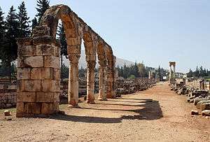 The cardo of the Umayyad city of Anjar | |
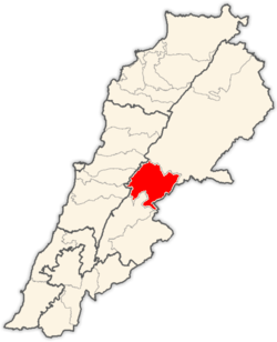
 Location in Lebanon | |
| Coordinates: 33°43′33″N 35°55′47″E / 33.72583°N 35.92972°ECoordinates: 33°43′33″N 35°55′47″E / 33.72583°N 35.92972°Eregion:LB_type:city | |
| Country | Lebanon |
| Governorate | Beqaa Governorate |
| District | Zahle District |
| Government | |
| • Mayor | [Vartkes Khoshian] |
| Time zone | UTC+2 (EET) |
| • Summer (DST) | +3 |
| Official name | Anjar |
| Type | Cultural |
| Criteria | iii, iv |
| Designated | 1984 (8th session) |
| Reference no. | 293 |
| State Party |
|
| Region | Arab States |

Anjar (Arabic: عنجر / ALA-LC: ‘Anjar; Armenian: Անճար French: Anjar, meaning "unresolved or running river"), also known as Haoush Mousa (Arabic: حوش موسى / Ḥawsh Mūsá), is a town of Lebanon located in the Bekaa Valley. The population is 2,400,[1] consisting almost entirely of Armenians. The total area is about twenty square kilometers (7.7 square miles). In the summer, the population swells to 3,500, as members of the Armenian diaspora return to visit there.
History
The town's establishment is normally attributed to the Umayyad caliph al-Walid I at the beginning of the 8th century as a palace-city. However, historian Jere L. Bacharach claims it was al-Walid's son, al-Abbas, who was responsible for Anjar's founding circa 714 CE, citing the Byzantine Greek chronicler Theophanes the Confessor, who recorded that al-Abbas built the town.
After being abandoned in later years, Anjar was resettled in 1939 with several thousand Armenian refugees from the Musa Dagh area. Its neighborhoods are named after the six villages of Musa Dagh: Haji Habibli, Kebusiyeh, Vakif, Kheder Bek, Yoghunoluk and Bitias. The Syrian Army chose Anjar as one of its main military bases in the Beqaa Valley and the headquarters of its intelligence services.
Religion and education
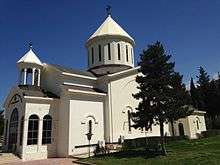
The majority of Anjar's Armenians are Armenian Apostolics (Orthodox) who belong to the Armenian Apostolic Church and Holy See of Cilicia. Armenian Apostolic Saint Paul Church is the second largest Armenian church in Lebanon.[2]
The Armenian Apostolic community has its own school, Haratch Calouste Gulbenkian Secondary School. In 1940, the chief editor of the Armenian newspaper Haratch in Paris, Shavarsh Missakian, organized a fundraising campaign among the Armenians living in France which enabled the building of the "Haratch" Elementary School next to the newly established St. Paul Armenian Apostolic Church. The official opening of the school took place in 1941. The administration of the Calouste Gulbenkian Foundation contributed to the expansion of the school, which was named in honor of Calouste Gulbenkian.
Our Lady of the Rosary Armenian Catholic Church in Anjar serves as church for the Armenian Catholics, who also run the Armenian Catholic Sisters School. In the beginning, the school had two divisions, St. Hovsep for the male students and Sisters of Immaculate Conception for the female students. In 1954, these departments were united. 1973 saw the official opening of the Aghajanian Orphan House, already serving as an Armenian Catholic orphanage since 1968.
The Armenian Evangelical Church of Anjar is in operation to serve Anjar's small Armenian Evangelical community. The Protestant community school was established in 1948 by Sister Hedwig Aienshanslin as part of her missionary work in Anjar. In 1953, the school, which had already become an intermediate school, was promoted into a secondary school. It has day classes as well as boarding facilities for students from other regions who stay there throughout the winter.
Anjar antiquities
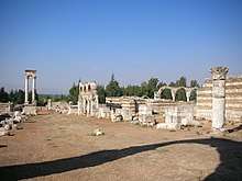
Formerly known as Gerrha, a stronghold built by Umayyad Caliph Al-Walid ibn Abdel Malek in the 8th century, the site was later abandoned, leaving a number of well-preserved ruins. The present-day name derives from Arabic Ayn Gerrha, or "source of Gerrha". The exclusively Umayyad ruins have been recognized as a World Heritage Site.
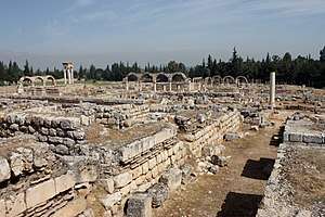
The city ruins cover 114,000 square meters and are surrounded by large, fortified stone walls over two meters thick and seven meters high. The rectangular city design of 370 m by 310 m is based on Roman city planning and architecture with stonework borrowed from the Byzantines. Two large avenues, the Cardo maximum, running north to south, and the Decumanus Maximus, running east to west, divide the city into four quadrants. The two main avenues, decorated with colonnades and flanked by about 600 shops, intersect under a tetrapylon. The plinths, shafts and capitals of the tetrapylon are spolia reused in the Umayyad period. Smaller streets subdivide the western half of the city in quarters of different size.[3]
Main monuments:
- The partially rebuilt Grand Palace, 59 m by 70 m, includes a wall and is preceded by a series of arcades. Its central courtyard is surrounded by a peristyle.
- The almost square Small Palace, 46 m by 47 m, stands out for its numerous ornamental fragments and its richly decorated central entrance.
- A Mosque, 45 m by 32 m, is located between the two palaces.
- Thermal baths, built on the Roman model.
The numerous fragments of friezes with plant, figurative and geometric motifs are proving of once rich decorated buildings.
See also
Gallery
 View of site, Anjar
 The Grand Palace
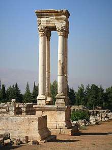 The tetrapylon, Anjar
 External wall of the Grand Palace, Anjar.
References
Bibliography
- Bacharach, Jere L. (1996). "Marwanid Umayyad Building Activities: Speculations on Patronage". In Necipoğlu, Gülru. Muqarnas: An Annual on the Visual Culture of the Islamic World. 13. Leiden: BRILL. pp. 27–44. ISBN 90-04-10633-2.
External links
| Wikimedia Commons has media related to Anjar. |
- Official Website of Anjar
- Anjar, Archnet Digital Library.
- Website about Anjar
- Lebanon, the Cedars' Land: Anjar
- Ya Libnan | Lebanon News | Spotlight on Anjar
- Photos of Anjar ruins
Capital: Zahlé | ||
| Towns and villages |
|  |
| ||
| Authority control |
|---|