Élise-Daucourt
| Élise-Daucourt | |
|---|---|
| Commune | |
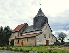 St. Nicholas' Church in Daucourt | |
 Élise-Daucourt Location within Grand Est region  Élise-Daucourt | |
| Coordinates: 49°02′48″N 4°52′04″E / 49.0467°N 4.8678°ECoordinates: 49°02′48″N 4°52′04″E / 49.0467°N 4.8678°E | |
| Country | France |
| Region | Grand Est |
| Department | Marne |
| Arrondissement | Châlons-en-Champagne |
| Canton | Argonne Suippe et Vesle |
| Intercommunality | Communauté de communes de la Région de Sainte-Menehould |
| Government | |
| • Mayor (2008–2014) | André Kandel |
| Area1 | 15.32 km2 (5.92 sq mi) |
| Population (2006)2 | 104 |
| • Density | 6.8/km2 (18/sq mi) |
| Time zone | UTC+1 (CET) |
| • Summer (DST) | UTC+2 (CEST) |
| INSEE/Postal code | 51228 /51800 |
|
1 French Land Register data, which excludes lakes, ponds, glaciers > 1 km2 (0.386 sq mi or 247 acres) and river estuaries. 2 Population without double counting: residents of multiple communes (e.g., students and military personnel) only counted once. | |
Élise-Daucourt is a commune in the Marne department in north-eastern France. The commune consists of 2 villages, Élise and Daucourt, which are 1 mile apart. Both villages were separate communes until 1965, when they merged. Since the merger Élise is often called Élise-Daucourt. Both villages lie about 6 km south of Sainte-Menehould, the nearest regional town.
See also
.JPG)
Church of St. Julian in Élise
.JPG)
Former town hall of Élise
.JPG)
Rural corner in Élise
External links
| Wikimedia Commons has media related to Élise-Daucourt. |
This article is issued from
Wikipedia.
The text is licensed under Creative Commons - Attribution - Sharealike.
Additional terms may apply for the media files.