Zonsverduistering van 12 november 1966
De totale zonsverduistering van 12 november 1966 trok veel over zee, maar was achtereenvolgens te zien in deze 6 landen : Peru, Bolivia, Chili, Argentinië, Paraguay en Brazilië.[1][2]
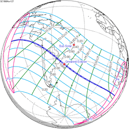
De zonsverduistering was te zien tussen de blauwe lijnen.
Lengte
Maximum
Het punt met maximale totaliteit lag op zee ver van enig land bij coördinatenpunt 35.6201° Zuid / 48.1542° West en duurde 1m57,2s.
Limieten
| Fenomeen | Code | Tijdstip UTC |
|---|---|---|
| Eerste contact bijschaduw | P1 | 11:42:52.8 |
| Eerste contact kernschaduw | U1 | 12:42:30.2 |
| Kernschaduw compleet vanaf | U2 | 12:42:57.2 |
| Bijschaduw compleet vanaf | P2 | 13:49:36.1 |
| Maximum eclips | GE | 14:22:50.7 |
| Bijschaduw compleet t/m | P3 | 14:55:45.0 |
| Kernschaduw compleet t/m | U3 | 16:02:38.1 |
| Laatste contact kernschaduw | U4 | 16:03:00.6 |
| Laatste contact bijschaduw | P4 | 17:02:47.6 |
Zie ook
Externe links
- NASA Google map van deze verduistering
- NASA overzicht van alle verduisteringen
Bronnen, noten en/of referenties
|
This article is issued from
Wikipedia.
The text is licensed under Creative
Commons - Attribution - Sharealike.
Additional terms may apply for the media files.