Sutton Bonington
Sutton Bonington is een civil parish in het bestuurlijke gebied Rushcliffe, in het Engelse graafschap Nottinghamshire.
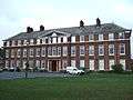 Gebouw van de universiteit van Nottingham in Sutton Bonington
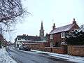 Hoofdstraat met uitzicht op de kerk van St. Michael
Geplaatst op: 5-8-2010 |
Dit artikel is een beginnetje over landen & volken. U wordt uitgenodigd om op bewerken te klikken om uw kennis aan dit artikel toe te voegen. |
| Civil parish in Engeland | |||
 | |||
| Situering | |||
| Regio | East Midlands | ||
| Graafschap | Nottinghamshire | ||
| District | Rushcliffe | ||
| Coördinaten | 52° 49' NB, 1° 15' WL | ||
| Algemeen | |||
| Oppervlakte | 8,9961 km² | ||
| Inwoners (2011) | 2202 (245 inw./km²) | ||
| Overig | |||
| Postcode(s) | LE12 | ||
| Netnummer(s) | 01509 | ||
| Post town | LOUGHBOROUGH | ||
| ONS-code | E04008005 | ||
| Foto's | |||
 | |||
| Straat in Sutton Bonington | |||
| |||
This article is issued from
Wikipedia.
The text is licensed under Creative
Commons - Attribution - Sharealike.
Additional terms may apply for the media files.