Rottofreno
Rottofreno is een gemeente in de Italiaanse provincie Piacenza (regio Emilia-Romagna) en telt 9670 inwoners (31-12-2004). De oppervlakte bedraagt 34,5 km², de bevolkingsdichtheid is 260 inwoners per km².
Gemeente in Italië | |||
 | |||
| Situering | |||
| Regio | Emilia-Romagna (EMR) | ||
| Provincie | Piacenza (PC) | ||
| Coördinaten | 45° 3′ NB, 9° 33′ OL | ||
| Algemeen | |||
| Oppervlakte | 34,5 km² | ||
| Inwoners (31 dec. 2013) | 11.967 (347 inw./km²) | ||
| Hoogte | 65 m | ||
| Overig | |||
| Postcode | 29010 | ||
| Netnummer | 0523 | ||
| ISTAT-code | 033039 | ||
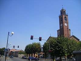
Foto's | |||
 | |||
| |||
De volgende frazioni maken deel uit van de gemeente: San Nicolò a Trebbia, Centora.
Demografie
Rottofreno telt ongeveer 3980 huishoudens. Het aantal inwoners steeg in de periode 1991-2001 met 12,9% volgens cijfers uit de tienjaarlijkse volkstellingen van ISTAT.
| Jaar | Inwoneraantal |
|---|---|
| 1991 | 7835 |
| 2001 | 8844 |
Geografie
De gemeente ligt op ongeveer 65 m boven zeeniveau.
Rottofreno grenst aan de volgende gemeenten: Borgonovo Val Tidone, Calendasco, Chignolo Po (PV), Gragnano Trebbiense, Monticelli Pavese (PV), Piacenza, Sarmato.
| Bronnen, noten en/of referenties |
| Gemeenten in de provincie Piacenza |
|---|
|
Agazzano · Alseno · Besenzone · Bettola · Bobbio · Borgonovo Val Tidone · Cadeo · Calendasco · Caminata · Caorso · Carpaneto Piacentino · Castel San Giovanni · Castell'Arquato · Castelvetro Piacentino · Cerignale · Coli · Corte Brugnatella · Cortemaggiore · Farini · Ferriere · Fiorenzuola d'Arda · Gazzola · Gossolengo · Gragnano Trebbiense · Gropparello · Lugagnano Val d'Arda · Monticelli d'Ongina · Morfasso · Nibbiano · Ottone · Pecorara · Piacenza · Pianello Val Tidone · Piozzano · Podenzano · Ponte dell'Olio · Pontenure · Rivergaro · Rottofreno · San Giorgio Piacentino · San Pietro in Cerro · Sarmato · Travo · Vernasca · Vigolzone · Villanova sull'Arda · Zerba · Ziano Piacentino |
| Zie de categorie Rottofreno van Wikimedia Commons voor mediabestanden over dit onderwerp. |