Polstead
Polstead is een civil parish in het bestuurlijke gebied Babergh, in het Engelse graafschap Suffolk. In 2001 telde het civil parish 808 inwoners.[1] De parish omvat de gehuchten Mill Street, Polstead Heath, Hadleigh Heath, Whitestreet Green en Bower House Tye.[2] Polstead komt in het Domesday Book (1086) voor als 'Polesteda'.[3]
| Civil parish in Engeland | |||
 | |||
| Situering | |||
| Regio | East of England | ||
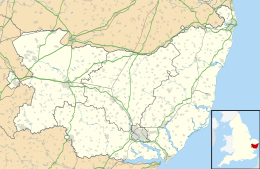
| Graafschap | Suffolk | ||
| District | Babergh | ||
| Coördinaten | 52° 0' NB, 0° 54' OL | ||
| Algemeen | |||
| Oppervlakte | 13,7865 km² | ||
| Inwoners (2011) | 851 (62 inw./km²) | ||
| Overig | |||
| Postcode(s) | CO6 | ||
| Netnummer(s) | 01206 | ||
| Grid code | TL991374 | ||
| Post town | COLCHESTER | ||
| ONS-code | E04009116 | ||
| Foto's | |||
 | |||
| Kerk | |||
| |||
Bronnen
Geplaatst op: 5-8-2010 |
Dit artikel is een beginnetje over landen & volken. U wordt uitgenodigd om op bewerken te klikken om uw kennis aan dit artikel toe te voegen. |
This article is issued from
Wikipedia.
The text is licensed under Creative
Commons - Attribution - Sharealike.
Additional terms may apply for the media files.