Looe
Looe (Cornisch: Logh) is een civil parish in het Engelse graafschap Cornwall. De plaats ligt ten zuiden van Liskeard en telt 5112 inwoners. De plaats is met een spoorlijn verbonden met Liskeard waar aansluiting bestaat op de hoofdlijn naar Penzance en Plymouth.
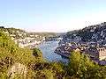 Rivier bij Looe
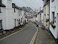 Straat in Looe
| Districten: | Cornwall · Scilly-eilanden |
| Steden: | Bodmin · Bude · Camborne · Falmouth · Hayle · Helston · Launceston · Liskeard · Newquay · Penzance · Redruth · Saltash · St. Austell · St. Ives · Truro · Wadebridge |
| Onderwerpen: | Vlag · Volk · Taal · Hertogdom · Mebyon Kernow · Cornish pasty |
Civil parishes in het ceremoniële graafschap Cornwall:
Advent ·
Altarnun ·
Antony ·
Blisland ·
Boconnoc ·
Bodmin ·
Botusfleming ·
Boyton ·
Breage ·
Broadoak ·
Bryher ·
Bude-Stratton ·
Budock ·
Callington ·
Calstock ·
Camborne ·
Camelford ·
Cardinham ·
Carharrack ·
Carn Brea ·
Chacewater ·
Colan ·
Constantine ·
Crantock ·
Crowan ·
Cubert ·
Cuby ·
Cury ·
Davidstow ·
Deviock ·
Dobwalls and Trewidland ·
Duloe ·
Egloshayle ·
Egloskerry ·
Falmouth ·
Feock ·
Forrabury and Minster ·
Fowey ·
Germoe ·
Gerrans ·
Grade-Ruan ·
Grampound with Creed ·
Gunwalloe ·
Gweek ·
Gwennap ·
Gwinear-Gwithian ·
Hayle ·
Helland ·
Helston ·
Illogan ·
Jacobstow ·
Kea ·
Kenwyn ·
Kilkhampton ·
Ladock ·
Landewednack ·
Landrake with St. Erney ·
Landulph ·
Laneast ·
Lanhydrock ·
Lanivet ·
Lanlivery ·
Lanner ·
Lanreath ·
Lansallos ·
Lanteglos ·
Launcells ·
Launceston ·
Lawhitton Rural ·
Lesnewth ·
Lewannick ·
Lezant ·
Linkinhorne ·
Liskeard ·
Looe ·
Lostwithiel ·
Ludgvan ·
Luxulyan ·
Mabe ·
Madron ·
Maker-with-Rame ·
Manaccan ·
Marazion ·
Marhamchurch ·
Mawgan-in-Meneage ·
Mawgan-in-Pydar ·
Mawnan ·
Menheniot ·
Mevagissey ·
Michaelstow ·
Millbrook ·
Morvah ·
Morval ·
Morwenstow ·
Mullion ·
Mylor ·
Newquay ·
North Hill ·
North Petherwin ·
North Tamerton ·
Otterham ·
Padstow ·
Paul ·
Pelynt ·
Penryn ·
Penzance ·
Perranarworthal ·
Perranuthnoe ·
Perranzabuloe ·
Philleigh ·
Pillaton ·
Porthleven ·
Portreath ·
Poundstock ·
Probus ·
Quethiock ·
Redruth ·
Roche ·
Ruanlanihorne ·
Saltash ·
Sancreed ·
Sennen ·
Sheviock ·
Sithney ·
South Hill ·
South Petherwin ·
St. Agnes (Scilly-eilanden) ·
St. Agnes (Cornwall) ·
St. Allen ·
St. Anthony-in-Meneage ·
St. Blaise ·
St. Breock ·
St. Breward ·
St. Buryan ·
St. Cleer ·
St. Clement ·
St. Clether ·
St. Columb Major ·
St. Day ·
St. Dennis ·
St. Dominick ·
St. Endellion ·
St. Enoder ·
St. Erme ·
St. Erth ·
St. Ervan ·
St. Eval ·
St. Ewe ·
St. Gennys ·
St. Germans ·
St. Gluvias ·
St. Goran ·
St. Hilary ·
St Issey ·
St Ive ·
St. Ives ·
St. John ·
St. Juliot ·
St Just ·
St. Just-in-Roseland ·
St Keverne ·
St Kew ·
St. Keyne ·
St Levan ·
St. Mabyn ·
St. Martin-by-Looe ·
St Martin-in-Meneage ·
St. Martin's ·
St. Mary's ·
St. Mellion ·
St Merryn ·
St Mewan ·
St. Michael Caerhays ·
St. Michael Penkevil ·
St Michael's Mount ·
St. Minver Highlands ·
St. Minver Lowlands ·
St Neot ·
St. Newlyn East ·
St. Pinnock ·
St. Sampson ·
St Stephen-in-Brannel ·
St. Stephens by Launceston Rural ·
St. Teath ·
St. Thomas the Apostle Rural ·
St Tudy ·
St Veep ·
St. Wenn ·
St Winnow ·
Stithians ·
Stokeclimsland ·
Tintagel ·
Torpoint ·
Towednack ·
Tregoney ·
Tremaine ·
Treneglos ·
Tresco ·
Tresmeer ·
Trevalga ·
Treverbyn ·
Trewen ·
Truro ·
Tywardreath and Par ·
Veryan ·
Wadebridge ·
Warbstow ·
Warleggan ·
Week St. Mary ·
Wendron ·
Werrington ·
Whitstone ·
Withiel ·
Zennor
Geplaatst op: 09-07-2007 |
Dit artikel is een beginnetje over landen & volken. U wordt uitgenodigd om op bewerken te klikken om uw kennis aan dit artikel toe te voegen. |
| Civil parish in Engeland | |||
 | |||
| Situering | |||
| Regio | South West England | ||
| Graafschap | Cornwall | ||
| District | (geen) | ||
| Coördinaten | 50° 21' NB, 4° 27' WL | ||
| Algemeen | |||
| Oppervlakte | 6,7950 km² | ||
| Inwoners (2011) | 5112 (752 inw./km²) | ||
| Overig | |||
| Postcode(s) | PL13 | ||
| Netnummer(s) | 01503 | ||
| Grid code | SX254533 | ||
| ONS-code | E04011473 | ||
| Foto's | |||
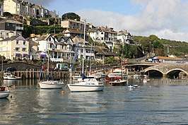 | |||
| De haven. | |||
| |||