Lijst van gemeentelijke monumenten in Bergen (Limburg)
De gemeente Bergen in de provincie Limburg heeft 84 gemeentelijke monumenten, hieronder een overzicht. Zie ook de rijksmonumenten in Bergen.
Afferden
De plaats Afferden kent 10 gemeentelijke monumenten:
| Object | Bouwjaar | Architect | Locatie | Coördinaten | Nr. | Afbeelding |
|---|---|---|---|---|---|---|
| Paterskapel | 1880[1] | Bleijenbeek ongenummerd in het bos nabij de ruïne van Kasteel Bleijenbeek | 51° 37' 38" NB, 6° 2' 40" OL | 0893/WN001 | 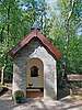 | |
| Jozefkapel | Bleijenbeek ongenummerd | 51° 38' 13" NB, 6° 3' 13" OL | 0893/WN002 | 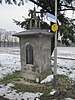 | ||
| Woonhuis | Dorpstraat 7 | 51° 38' 9" NB, 6° 0' 27" OL | 0893/WN003 | Upload foto | ||
| Hotel Sleutels | Dorpstraat 64 | 51° 38' 2" NB, 6° 0' 39" OL | 0893/WN004 | Upload foto | ||
| Voormalige pastorie thans woonhuis | Dorpstraat 70 | 51° 38' 2" NB, 6° 0' 34" OL | 0893/WN009 | Upload foto | ||
| Veldkruis | Kapelstraat bij 43 | 51° 38' 14" NB, 6° 1' 1" OL | 0893/WN005 | 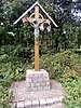 | ||
| Toegangspoort van het kerkhof | Langstraat ongenummerd | 51° 38' 4" NB, 6° 0' 47" OL | 0893/WN006 | Upload foto | ||
| HH. Cosmas en Damianuskerk | 1958[2] | Kayser, J.H.J. | Mgr. Fredrixplein 4 | 51° 38' 3" NB, 6° 0' 33" OL | 0893/WN007 | 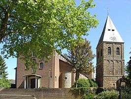 |
| Boerderij | Rimpelt 19 | 51° 38' 4" NB, 6° 1' 46" OL | 0893/WN008 | Upload foto | ||
| Boerderij thans woning | Hengeland 20 | 51° 38' 51" NB, 6° 0' 24" OL | 0893/WN010 | Upload foto |
Aijen
De plaats Aijen kent 1 gemeentelijk monument:
| Object | Bouwjaar | Architect | Locatie | Coördinaten | Nr. | Afbeelding |
|---|---|---|---|---|---|---|
| Voormalige boerderij thans woonhuis | Aijen 4c-6 | 51° 34' 57" NB, 6° 2' 33" OL | 0893/WN011 | Upload foto |
Bergen
De plaats Bergen kent 19 gemeentelijke monumenten:
| Object | Bouwjaar | Architect | Locatie | Coördinaten | Nr. | Afbeelding |
|---|---|---|---|---|---|---|
| Boerderij de Vorstenhof | Aijenseweg 7 | 51° 35' 24" NB, 6° 2' 35" OL | 0893/WN012 | Upload foto | ||
| St. Antonius van Padua kapelletje in Traditionalisme stijl | XX a | Aijenseweg ongenummerd | 51° 35' 17" NB, 6° 2' 20" OL | 0893/WN013 | Upload foto | |
| Veldkruis | Aijenseweg bij 3 | 51° 35' 39" NB, 6° 2' 8" OL | 0893/WN014 | Upload foto | ||
| Voormalige boerderij thans woonhuis in Traditionalisme stijl | 1924-25 | Aijerdijk 6 | 51° 35' 18" NB, 6° 2' 60" OL | 0893/WN015 | Upload foto | |
| Fabrieksgebouw Meldon Plastics | De Flammert 1102 | 51° 36' 37" NB, 6° 2' 25" OL | 0893/WN016 | Upload foto | ||
| H. Petruskerk | 1932 Herbouw:1948-1950[3] |
Martinus van Beek | Kerkstraat 6 | 51° 35' 59" NB, 6° 2' 0" OL | 0893/WN017 | Upload foto |
| Pastorie in 19e-eeuws traditioneel stijl | Eind 19e eeuw[4] | Kerkstraat 8 | 51° 35' 59" NB, 6° 2' 1" OL | 0893/WN018 | Upload foto | |
| Mariaschool | ca. 1955[4] | Kerkstraat 15 | 51° 35' 60" NB, 6° 2' 7" OL | 0893/WN019 | Upload foto | |
| Woonhuis in Traditionalisme stijl | ca 1924 | Kerkstraat 17 | 51° 35' 59" NB, 6° 2' 7" OL | 0893/WN020 | Upload foto | |
| Veldkruis | Maasstraat bij 10 | 51° 35' 56" NB, 6° 1' 51" OL | 0893/WN021 | Upload foto | ||
| Veldkruis | Op de Paal ongenummerd | 0893/WN022 | Upload foto | |||
| Voormalige boerderij thans woonhuis (exclusief de achterbouw) in 19e-eeuws traditioneel stijl | Eind 19e eeuw[4] | Oude Kerkstraat 8 | 51° 36' 1" NB, 6° 1' 57" OL | 0893/WN023 | Upload foto | |
| Voormalige boerderij thans woonhuis | 1778 (kern), 1881 (gevel)[4] | Oude Kerkstraat 11 | 51° 36' 3" NB, 6° 1' 54" OL | 0893/WN024 | Upload foto | |
| Kerkhofmuur | Oude Kerkstraat ongenummerd | 51° 36' 3" NB, 6° 1' 54" OL | 0893/WN025 | Upload foto | ||
| Voormalige boerderij thans woonhuis in Traditionalisme stijl | XX a | Parallelweg 8 | 51° 35' 8" NB, 6° 3' 52" OL | 0893/WN026 | Upload foto | |
| Voormalige tramhal, thans atelier in Traditionalisme stijl | 1913[4] | Rijksweg 2 | 51° 36' 17" NB, 6° 2' 46" OL | 0893/WN027 | Upload foto | |
| Transformatorhuisje | Rijksweg 43 | 51° 35' 26" NB, 6° 3' 42" OL | 0893/WN028 | Upload foto | ||
| Voormalige stoom-zuivelfabriek St. Antonius Abt en naast gelegen voormalige directeurswoning | Rijksweg 44-46 | 51° 35' 23" NB, 6° 3' 40" OL | 0893/WN029 | Upload foto | ||
| Voormalige boerderij thans woonhuis | Weth. Kortingstraat 8 | 51° 35' 6" NB, 6° 2' 34" OL | 0893/WN030 | Upload foto |
Siebengewald
De plaats Siebengewald kent 10 gemeentelijke monumenten:
| Object | Bouwjaar | Architect | Locatie | Coördinaten | Nr. | Afbeelding |
|---|---|---|---|---|---|---|
| Voormalige marechausseekazerne thans woonhuis in Traditionalisme stijl | ca 1926 | Augustinusweg 2 | 51° 39' 10" NB, 6° 6' 47" OL | 0893/WN031 | Upload foto | |
| Voormalige boerderij thans woonhuis | Augustinusweg 34 | 51° 39' 29" NB, 6° 6' 1" OL | 0893/WN032 | Upload foto | ||
| H. Jozefkerk | Boterdijk 2 | 51° 39' 7" NB, 6° 5' 55" OL | 0893/WN033 | 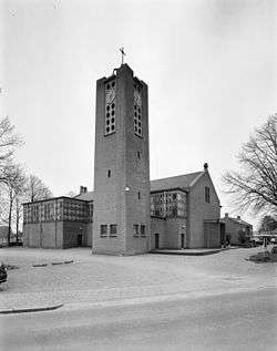 | ||
| Veldkruis | Gaesdoncksestraat ongenummerd | 0893/WN034 | Upload foto | |||
| Boerderij thans woonhuis | Gochsedijk 8 | 51° 38' 26" NB, 6° 5' 21" OL | 0893/WN035 | Upload foto | ||
| Boerderij | Gochsedijk 11 | 51° 38' 21" NB, 6° 5' 7" OL | 0893/WN036 | Upload foto | ||
| Veldkruis | Gochsedijk ongenummerd | 0893/WN037 | Upload foto | |||
| Voormalige klooster thans appartementencomplex | Kloosterweg 13-15-17-19-21 | 51° 39' 19" NB, 6° 6' 16" OL | 0893/WN038 | Upload foto | ||
| Pastorie | Nieuweweg 98 | 51° 39' 6" NB, 6° 5' 55" OL | 0893/WN039 | Upload foto | ||
| Voormalige boerderij thans woonhuis in Traditionalisme stijl | ca 1915 | Augustinusweg 9 | 51° 39' 11" NB, 6° 6' 41" OL | 0893/WN040 | Upload foto |
Well
De plaats Well kent 32 gemeentelijke monumenten:
| Object | Bouwjaar | Architect | Locatie | Coördinaten | Nr. | Afbeelding |
|---|---|---|---|---|---|---|
| Veldkruis | Bont Kamp ongenummerd | 0893/WN041 | Upload foto | |||
| Boerderij Huberdenhof | De Kamp 1 | 51° 34' 15" NB, 6° 3' 18" OL | 0893/WN042 | Upload foto | ||
| Voormalige boerderij | De Kamp 5 | 51° 34' 3" NB, 6° 3' 38" OL | 0893/WN043 | Upload foto | ||
| Boerderij St. Jacobshoeve | De Kamp 8 | 51° 34' 5" NB, 6° 3' 23" OL | 0893/WN044 | Upload foto | ||
| Voormalige boerderij thans woonhuis | De Kamp 10 | 51° 33' 59" NB, 6° 3' 27" OL | 0893/WN045 | 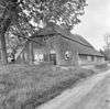 | ||
| Kapel van Onze Lieve Vrouw van zeven smarten | 1923[5] | De Kamp bij 12 | 51° 33' 55" NB, 6° 2' 43" OL | 0893/WN048 | 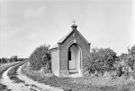 | |
| Boerderij Kapelhof in Traditionalisme stijl | 1930 | De Kamp 16 | 51° 33' 56" NB, 6° 3' 33" OL | 0893/WN046 | Upload foto | |
| Vrijstaande schuur | De Kamp bij 16 | 0893/WN047 | Upload foto | |||
| Voormalige boerderij thans woonhuis | de Paad 3 | 51° 33' 28" NB, 6° 4' 57" OL | 0893/WN049 | Upload foto | ||
| Voormalige boerderij thans woonhuis | Elsteren 6 | 51° 33' 13" NB, 6° 4' 42" OL | 0893/WN050 | Upload foto | ||
| Voormalige boerderij thans woonhuis | Elsteren 11 | 51° 33' 17" NB, 6° 4' 37" OL | 0893/WN051 | Upload foto | ||
| Voormalige boerderij thans woonhuis | Elsterendijk 28 | 51° 33' 30" NB, 6° 4' 57" OL | 0893/WN052 | Upload foto | ||
| Woonhuis in Traditionalisme stijl | ca 1925 | Grotestraat 7 | 51° 32' 57" NB, 6° 5' 46" OL | 0893/WN053 | Upload foto | |
| Veerhuis, nu horeca | circa 1880 | Grotestraat 11 | 51° 32' 54" NB, 6° 5' 28" OL | 0893/WN054 | Upload foto | |
| Oudste Veerhuis en Woonhuis | 1900 | Grotestraat 13 | 51° 32' 54" NB, 6° 5' 27" OL | 0893/WN055 | Upload foto | |
| Later gesplitst dwars huis | 1676, 19de-eeuwse topgevel[6] | Grotestraat 21-23 | 51° 32' 54" NB, 6° 5' 25" OL | 0893/WN056 | Upload foto | |
| Woonhuis | Grotestraat 36 | 51° 32' 54" NB, 6° 5' 32" OL | 0893/WN057 | Upload foto | ||
| Voormalig Pruisisch tolkantoor/Dokterswoning met invloeden van Neorenaissance-stijl | gevel ca. 1875[6] | Grotestraat 37 | 51° 32' 56" NB, 6° 5' 21" OL | 0893/WN058 | Upload foto | |
| Woonhuis | Grotestraat 41 | 51° 32' 56" NB, 6° 5' 18" OL | 0893/WN059 | Upload foto | ||
| Voormalige 17e-eeuwse herberg Het Roode Hert met gevel in 19e-eeuwse traditionele stijl | gevel ca. 1870[6] | Grotestraat 48-50 | 51° 32' 54" NB, 6° 5' 28" OL | 0893/WN060 | Upload foto | |
| Voormalige horecagelegenheid met woonhuis Walaria in 19e-eeuws traditioneel stijl | ca. 1880[6] | Grotestraat 60 | 51° 32' 55" NB, 6° 5' 25" OL | 0893/WN061 | Upload foto | |
| Woonhuis (exclusief de voorbouw/winkel) | 1886 | Grotestraat 74 | 51° 32' 56" NB, 6° 5' 22" OL | 0893/WN062 | Upload foto | |
| H. Vituskerk | 1956-1958[7] | Jan Ramaekers | Hoenderstraat 9 | 51° 32' 60" NB, 6° 5' 24" OL | 0893/WN063 | Upload foto |
| Pastorie in 19e-eeuws traditioneel stijl | 1781 met latere gevel ca. 1875[6] | Wirtz | Hoenderstraat 16 | 51° 32' 58" NB, 6° 5' 25" OL | 0893/WN064 | Upload foto |
| Transformatorhuisje in Traditionalisme stijl | 1935 | Hoenderstraat 32 | 51° 32' 57" NB, 6° 5' 32" OL | 0893/WN065 | Upload foto | |
| Voormalige boerderij (woonhuis en schuur) | Kasteellaan 17-19 | 51° 33' 19" NB, 6° 5' 35" OL | 0893/WN066 | Upload foto | ||
| Veldkruis | Kasteellaan bij 20 | 0893/WN067 | Upload foto | |||
| Veldkruis | Kasteellaan bij 23 | 0893/WN068 | Upload foto | |||
| Voormalige brouwerij thans hotel/restaurant Grote Waaij | Kevelaarsedijk 1 | 51° 33' 10" NB, 6° 6' 25" OL | 0893/WN069 | 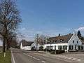 | ||
| Voormalig tolhuis thans woonhuis | Knikkerdorp 10 | 51° 32' 38" NB, 6° 7' 5" OL | 0893/WN070 | Upload foto | ||
| Mariakapel | Knikkerdorpweg bij 8 | 0893/WN071 | Upload foto | |||
| Transformatorhuisje | Moleneind 11 | 51° 33' 28" NB, 6° 5' 37" OL | 0893/WN072 | Upload foto |
Wellerlooi
De plaats Wellerlooi kent 12 gemeentelijke monumenten:
| Object | Bouwjaar | Architect | Locatie | Coördinaten | Nr. | Afbeelding |
|---|---|---|---|---|---|---|
| St. Antonius van Padua kapel in Neogotiek stijl | ca 1905 | Catharinastraat bij 24 | 51° 32' 2" NB, 6° 8' 11" OL | 0893/WN073 | Upload foto | |
| H. Catharinakerk | 1953[8] | Pierre Weegels | Catharinastraat 26 | 51° 32' 4" NB, 6° 8' 12" OL | 0893/WN074 | 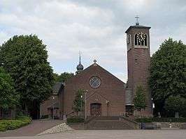 |
| Voormalige houthandel thans boerderij Kanaalmond in Traditionalisme stijl | ca 1910 / 1860[9] | Hamert 6 | 51° 30' 20" NB, 6° 10' 17" OL | 0893/WN075 | Upload foto | |
| Voormalig bakhuisje | Kruisstraat tegenover 41 | 51° 32' 16" NB, 6° 7' 46" OL | 0893/WN076 | Upload foto | ||
| Voormalige boerderij (exclusief de vrijstaande schuur) | Kruisstraat 41 | 51° 32' 15" NB, 6° 7' 47" OL | 0893/WN077 | Upload foto | ||
| Voormalige boerderij (woonhuis en vrijstaande schuur) in 19e-eeuws traditioneel stijl | 1859 | Looierweg 2 | 51° 31' 52" NB, 6° 8' 2" OL | 0893/WN078 | Upload foto | |
| St. Annakapel | Looierweg bij 9 | 51° 31' 55" NB, 6° 8' 2" OL | 0893/WN079 | Upload foto | ||
| Voormalige boerderij thans woonhuis | Rijksweg-Zuid 18 | 51° 31' 42" NB, 6° 8' 6" OL | 0893/WN080 | Upload foto | ||
| Veldkruis | Rijksweg-zuid ongenummerd tegenover de Kruisstraat | 51° 32' 9" NB, 6° 7' 29" OL | 0893/WN081 | Upload foto | ||
| Voormalige boerderij thans woonhuis (exclusief de vrijstaande schuur) | Schaak 2 | 51° 32' 18" NB, 6° 7' 46" OL | 0893/WN082 | Upload foto | ||
| Veldkruis | Tuinstraat / Venweg | 51° 32' 55" NB, 6° 9' 49" OL | 0893/WN083 | 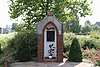 | ||
| Gedachtenismonument op landgoed De Hamert | 1950[10] | Twistedenerweg ongenummerd | 51° 31' 6" NB, 6° 11' 1" OL | 0893/WN084 |  |
| Zie de categorie Gemeentelijke monumenten in Bergen, Limburg van Wikimedia Commons voor mediabestanden over dit onderwerp. |
Bronnen, noten en/of referenties
|
This article is issued from
Wikipedia.
The text is licensed under Creative
Commons - Attribution - Sharealike.
Additional terms may apply for the media files.