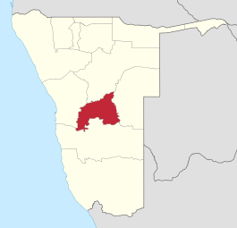
Khomas
Khomas is een bestuurlijke regio in Namibië. De naam Khomas komt van het berggebied Khomas Hochland.
Regio in Namibië | |||
 | |||
| Coördinaten | 22°48'ZB, 17°0'OL | ||
| Algemeen | |||
| Oppervlakte | 36.964 km² | ||
| Inwoners (2011) | 340.900 (9,2 inw./km²) | ||
| Hoofdstad | Windhoek | ||
| Overig | |||
| Talen | Engels, Afrikaans, Oshiwambo | ||
| Tijdzone | +1 | ||
| Religie | christendom | ||
| |||
De Khomas regio vormt het economische en politieke centrum van Namibië. In het dunbevolkte Namibië is Khomas een van de dichtstbevolkte gebieden.[1]
De regio kent tien kiesdistricten (Engels: constituency): Katatura Central, Katatura East, Khomasdal North, Moses/Garoeb, Samora Machel, Soweto, Tobias Hainyeko, Windhoek East, Windhoek Rural en Windhoek West.
Plaatsen
- Aris, village van 1992 tot 1993
- Kappsfarm, village van 1992 tot 1993
- Windhoek, municipality, 716 km²
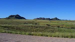
Berggebied Khomas Hochland
| Bronnen, noten en/of referenties |
| Regio's van Namibië | |
|---|---|
|
Zambezi · Erongo · Hardap · !Karas · Kavango Oost · Kavango West · Khomas · Kunene · Ohangwena · Omaheke · Omusati · Oshana · Oshikoto · Otjozondjupa | |
| Zie de categorie Khomas van Wikimedia Commons voor mediabestanden over dit onderwerp. |
This article is issued from
Wikipedia.
The text is licensed under Creative
Commons - Attribution - Sharealike.
Additional terms may apply for the media files.