Itapetininga (microregio)
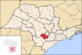
Itapetininga is een van de 63 microregio's van de Braziliaanse deelstaat São Paulo. Zij ligt in de mesoregio Itapetininga en grenst aan de microregio's Tatuí, Sorocaba, Piedade, Capão Bonito, Itapeva, Avaré en Botucatu. De microregio heeft een oppervlakte van ca. 3.730 km². In 2006 werd het inwoneraantal geschat op 185.482.
 | |||
| Situering | |||
| Deelstaat | São Paulo | ||
| Mesoregio | Itapetininga | ||
| Gemeenten | 5 | ||
| Coördinaten | 23°35'30,8"ZB, 48°3'10,1"WL | ||
| Algemeen | |||
| Oppervlakte | 3.730,308 km² | ||
| Inwoners | 185.482 (49,7 inw./km²) | ||
| |||
Vijf gemeenten behoren tot deze microregio:
This article is issued from
Wikipedia.
The text is licensed under Creative
Commons - Attribution - Sharealike.
Additional terms may apply for the media files.