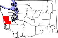
Grays Harbor County
Grays Harbor County is een van de 39 county's in de Amerikaanse staat Washington.
| County in de Verenigde Staten | |||
 | |||
| Situering | |||
| Staat | Washington | ||
| Tijdzone | Pacific Standard Time (UTC−8) | ||
| Coördinaten | 47°9'0"NB, 123°49'48"WL | ||
| Algemeen | |||
| Oppervlakte | 5.762 km² | ||
| - land | 4.965 km² | ||
| - water | 797 km² | ||
| Inwoners (2000) | 67.194 (14 inw./km²) | ||
| Overig | |||
| Zetel | Montesano | ||
| FIPS-code | 53027 | ||
| Opgericht | 1854 | ||
| Foto's | |||
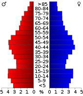 Bevolkingspiramide Grays Harbor County | |||
| Statistieken volkstelling Grays Harbor County | |||
| |||
De county heeft een landoppervlakte van 4.965 km² en telt 67.194 inwoners (volkstelling 2000). De hoofdplaats is Montesano.
Bevolkingsontwikkeling
| Historische inwonertallen | |||
|---|---|---|---|
| Jaar | Inwoners | % ± | |
| 1900 | 15.124 | ||
| 1910 | 35.590 | 135,3% | |
| 1920 | 44.745 | 25,7% | |
| 1930 | 59.982 | 34,1% | |
| 1940 | 53.166 | −11,4% | |
| 1950 | 53.644 | 0,9% | |
| 1960 | 54.465 | 1,5% | |
| 1970 | 59.553 | 9,3% | |
| 1980 | 66.314 | 11,4% | |
| 1990 | 64.175 | −3,2% | |
| 2000 | 67.194 | 4,7% | |
| Bron: (en) Historical Decennial Census Population | |||
| County's in Washington |
|---|
|
Adams · Asotin · Benton · Chelan · Clallam · Clark · Columbia · Cowlitz · Douglas · Ferry · Franklin · Garfield · Grant · Grays Harbor · Island · Jefferson · King · Kitsap · Kittitas · Klickitat · Lewis · Lincoln · Mason · Okanogan · Pacific · Pend Oreille · Pierce · San Juan · Skagit · Skamania · Snohomish · Spokane · Stevens · Thurston · Wahkiakum · Whatcom · Whitman · Yakima |
| Zie de categorie Grays Harbor County, Washington van Wikimedia Commons voor mediabestanden over dit onderwerp. |
This article is issued from
Wikipedia.
The text is licensed under Creative
Commons - Attribution - Sharealike.
Additional terms may apply for the media files.