Benton County (Washington)
Benton County is een van de 39 county's in de Amerikaanse staat Washington.
| County in de Verenigde Staten | |||
 | |||
| Situering | |||
| Staat | Washington | ||
| Tijdzone | Pacific Standard Time (UTC−8) | ||
| Coördinaten | 46°15'NB, 119°30'WL | ||
| Algemeen | |||
| Oppervlakte | 4.559 km² | ||
| - land | 4.411 km² | ||
| - water | 148 km² | ||
| Inwoners (2000) | 142.475 (32 inw./km²) | ||
| Overig | |||
| Zetel | Prosser | ||
| FIPS-code | 53005 | ||
| Opgericht | 1905 | ||
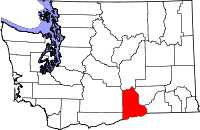
| Detailkaart | |||
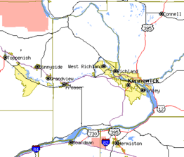 | |||
| Overzichtskaart van Benton County | |||
| Foto's | |||
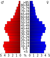 Bevolkingspiramide Benton County | |||
| Statistieken volkstelling Benton County | |||
| |||
De county heeft een landoppervlakte van 4.411 km² en telt 142.475 inwoners (volkstelling 2000). Het bestuurscentrum is Prosser, de grootste plaatsen zijn Richland en Kennewick.
Plaatsen in Benton County
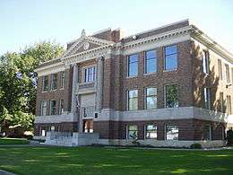
Benton County Courthouse
| County's in Washington |
|---|
|
Adams · Asotin · Benton · Chelan · Clallam · Clark · Columbia · Cowlitz · Douglas · Ferry · Franklin · Garfield · Grant · Grays Harbor · Island · Jefferson · King · Kitsap · Kittitas · Klickitat · Lewis · Lincoln · Mason · Okanogan · Pacific · Pend Oreille · Pierce · San Juan · Skagit · Skamania · Snohomish · Spokane · Stevens · Thurston · Wahkiakum · Whatcom · Whitman · Yakima |
| Zie de categorie Benton County, Washington van Wikimedia Commons voor mediabestanden over dit onderwerp. |
This article is issued from
Wikipedia.
The text is licensed under Creative
Commons - Attribution - Sharealike.
Additional terms may apply for the media files.