Bátonyterenye
Bátonyterenye is een plaats (város) en gemeente in het Hongaarse comitaat Nógrád. Bátonyterenye telt 12.443 inwoners (2015) en is de hoofdplaats van het gelijknamige district.
Stad in Hongarije | |||
| |||
 | |||
| Situering | |||
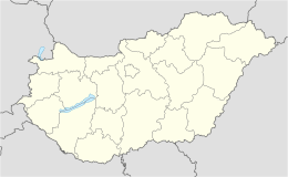
| Comitaat | Nógrád | ||
| District | Bátonyterenye | ||
| NUTS-regio | Észak-Magyarország | ||
| Coördinaten | 47° 59' NB, 19° 50' OL | ||
| Algemeen | |||
| Oppervlakte | 78,9 km² | ||
| Inwoners (1-1-2015) | 12.443 (164,3 inw./km²) | ||
| Overig | |||
| Postcode | 3070 | ||
| Netnummer | 32 | ||
| Website | www.batonyterenye.hu | ||
Foto's | |||
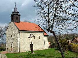 | |||
| De kerk van Maconka | |||
| |||


Bátonyterenye bestaat sinds 1984 en ontstond door de samenvoeging van Nagybátony , Kisterenye en Szúpatak. De fusiegemeente kreeg in 1989 de status van stad. Nagybátony behoorde tot 1950 tot het comitaat Heves, evenals Maconka, dat in 1965 samenging met Nagybátony.
This article is issued from
Wikipedia.
The text is licensed under Creative
Commons - Attribution - Sharealike.
Additional terms may apply for the media files.