Burntwood
Burntwood is een civil parish in het bestuurlijke gebied Lichfield, in het Engelse graafschap Staffordshire. De plaats telt 26.049 inwoners.
| Civil parish in Engeland | |||
 | |||
| Situering | |||
| Regio | West Midlands | ||
| Graafschap | Staffordshire | ||
| District | Lichfield | ||
| Coördinaten | 52° 41' NB, 1° 55' WL | ||
| Algemeen | |||
| Oppervlakte | 15,7988 km² | ||
| Inwoners (2011) | 26049 (1649 inw./km²) | ||
| Overig | |||
| Postcode(s) | WS7 | ||
| Netnummer(s) | 01543 | ||
| Grid code | SK055095 | ||
| Post town | BURNTWOOD | ||
| ONS-code | E04008917 | ||
| Foto's | |||
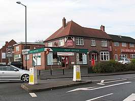 | |||
| Postkantoor | |||
| |||
Geboren
- Alan Wiley (1960), Engels voetbalscheidsrechter
Geplaatst op: 14-07-2007 |
Dit artikel is een beginnetje over landen & volken. U wordt uitgenodigd om op bewerken te klikken om uw kennis aan dit artikel toe te voegen. |
This article is issued from
Wikipedia.
The text is licensed under Creative
Commons - Attribution - Sharealike.
Additional terms may apply for the media files.