Lichfield (district)
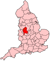
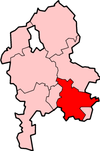
Lichfield is een Engels district in het shire-graafschap (non-metropolitan county OF county) Staffordshire en telt 104.000 inwoners. De oppervlakte bedraagt 331 km².
| Niet-metropolitaans district in Engeland | |||
  | |||
| Situering | |||
| Land | Engeland | ||
| County | Staffordshire | ||
| Regio | West Midlands | ||
| Coördinaten | 52°40'51"NB, 1°49'39"WL | ||
| Algemeen | |||
| Oppervlakte | 331,2944[1] km² | ||
| Inwoners (2018[2]) | 103965 (314 inw./km²) | ||
| ONS-code | E07000194 | ||
| |||
Van de bevolking is 15,5% ouder dan 65 jaar. De werkloosheid bedraagt 2,5% van de beroepsbevolking (cijfers volkstelling 2001).
Civil parishes in district Lichfield
Alrewas, Armitage with Handsacre, Burntwood, Clifton Campville, Colton, Curborough and Elmhurst, Drayton Bassett, Edingale, Elford, Farewell and Chorley, Fazeley, Fisherwick, Fradley and Streethay, Hammerwich, Hamstall Ridware, Harlaston, Hints, King’s Bromley, Lichfield, Longdon, Mavesyn Ridware, Shenstone, Swinfen and Packington, Thorpe Constantine, Wall, Weeford, Whittington, Wigginton and Hopwas.
Bronnen, noten en/of referenties
|
This article is issued from
Wikipedia.
The text is licensed under Creative
Commons - Attribution - Sharealike.
Additional terms may apply for the media files.