Aylesbury
Aylesbury is een civil parish in het bestuurlijke gebied Aylesbury Vale, in het Engelse graafschap Buckinghamshire. De plaats telt 58.740 inwoners.
| Civil parish in Engeland | |||
 | |||
| Situering | |||
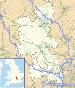
| Regio | South East England | ||
| Graafschap | Buckinghamshire | ||
| District | Aylesbury Vale | ||
| Coördinaten | 51° 49' NB, 0° 49' WL | ||
| Algemeen | |||
| Oppervlakte | 21,8626 km² | ||
| Inwoners (2011) | 58740 (2687 inw./km²) | ||
| Overig | |||
| Postcode(s) | HP19, HP20, HP21 | ||
| Netnummer(s) | 01296 | ||
| Grid code | SP818138 | ||
| Post town | AYLESBURY | ||
| ONS-code | E04001559 | ||
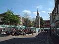
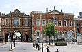
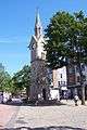
| Foto's | |||
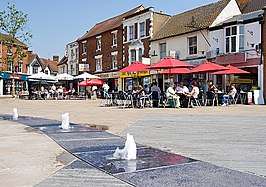 | |||
| Kingsbury square | |||
| |||
Verkeer en vervoer
Bekende inwoners
Geboren
- Michael Apted (1941), film- en televisieregisseur en -producent
- Sue Bond (1945), actrice
- Andrea Leadsom (1963), politica
- Chris Bradford (1974), schrijver en muzikant
- Emmerson Boyce (1979), voetballer
Overleden
- James Clark Ross (1800-1862), marineofficier en poolverkenner
- Mike Smith (1943-2008), zanger van The Dave Clark Five
- Heather Couper (1949-2020), sterrenkundige
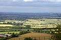
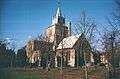
Galerij

| Bronnen, noten en/of referenties
|
Addington · Adstock · Akeley · Amersham · Ashendon · Ashley Green · Aston Abbotts · Aston Clinton · Aston Sandford · Astwood · Aylesbury · Barton Hartshorn · Beachampton · Beaconsfield · Biddlesden · Bierton with Broughton · Bledlow-cum-Saunderton · Bletchley and Fenny Stratford · Boarstall · Bow Brickhill · Bradenham · Bradwell · Bradwell Abbey · Brill · Broughton · Buckingham · Buckland · Burnham · Calvert Green · Calverton · Campbell Park · Castlethorpe · Central Milton Keynes · Chalfont St. Giles · Chalfont St. Peter · Charndon · Chartridge · Chearsley · Cheddington · Chenies · Chepping Wycombe · Chesham · Chesham Bois · Chetwode · Chicheley · Chilton · Cholesbury-cum-St. Leonards · Clifton Reynes · Cold Brayfield · Coldharbour · Coleshill · Creslow · Cublington · Cuddington · Denham · Dinton-with-Ford-and-Upton · Dorney · Dorton · Downley · Drayton Beauchamp · Drayton Parslow · Dunton · East Claydon · Edgcott · Edlesborough · Ellesborough · Emberton · Farnham Royal · Fawley · Fleet Marston · Foscott · Fulmer · Gawcott with Lenborough · Gayhurst · Gerrards Cross · Granborough · Great and Little Hampden · Great and Little Kimble · Great Brickhill · Great Horwood · Great Linford · Great Marlow · Great Missenden · Grendon Underwood · Haddenham · Halton · Hambleden · Hanslope · Hardmead · Hardwick · Haversham-cum-Little Linford · Hazlemere · Hedgerley · Hedsor · Hillesden · Hoggston · Hogshaw · Hughenden Valley · Hulcott · Ibstone · Ickford · Iver · Ivinghoe · Kents Hill, Monkston and Brinklow · Kingsey · Kingswood · Lacey Green · Lane End · Lathbury · Latimer · Lavendon · Leckhampstead · Lillingstone Dayrell · Lillingstone Lovell · Little Brickhill · Little Chalfont · Little Horwood · Little Marlow · Little Missenden · Long Crendon · Longwick-cum-Ilmer · Loughton · Ludgershall · Maids Moreton · Marlow · Marlow Bottom · Marsh Gibbon · Marsworth · Medmenham · Mentmore · Middle Claydon · Milton Keynes · Moulsoe · Mursley · Nash · Nether Winchendon · New Bradwell · Newport Pagnell · Newton Blossomville · Newton Longville · North Crawley · North Marston · Oakley · Olney · Oving · Padbury · Penn · Piddington and Wheeler End · Pitchcott · Pitstone · Poundon · Preston Bissett · Princes Risborough · Quainton · Quarrendon · Radclive-cum-Chackmore · Radnage · Ravenstone · Seer Green · Shabbington · Shalstone · Shenley Brook End · Shenley Church End · Sherington · Simpson · Slapton · Soulbury · Stantonbury · Steeple Claydon · Stewkley · Stoke Goldington · Stoke Hammond · Stoke Mandeville · Stoke Poges · Stokenchurch · Stone with Bishopstone and Hartwell · Stony Stratford · Stowe · Swanbourne · Taplow · The Lee · Thornborough · Thornton · Tingewick · Turville · Turweston · Twyford · Tyringham and Filgrave · Upper Winchendon · Waddesdon · Walton · Warrington · Water Stratford · Watermead · Wavendon · Weedon · Wendover · West Bletchley · West Wycombe · Westbury · Westcott · Weston Turville · Weston Underwood · Wexham · Whaddon · Whitchurch · Wing · Wingrave and Rowsham · Winslow · Woburn Sands · Wolverton and Greenleys · Wooburn and Bourne End · Woodham · Worminghall · Wotton Underwood · Woughton
Geplaatst op: 11-07-2007 |
Dit artikel is een beginnetje over landen & volken. U wordt uitgenodigd om op bewerken te klikken om uw kennis aan dit artikel toe te voegen. |