Westmorland
Westmorland (/ˈwɛstmərlənd/; formerly also spelt Westmoreland;[6] even older spellings are Westmerland and Westmereland) is a historic county in north west England. It formed an administrative county between 1889 and 1974, after which the whole county was administered by the new administrative county of Cumbria. In 2013, the Secretary of State for Communities and Local Government, Eric Pickles, formally recognised and acknowledged the continued existence of England's 39 historic counties, including Westmorland.[3][4][5]
| Westmorland | |
|---|---|
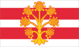 Flag | |
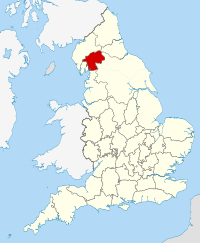 Ancient extent of Westmorland | |
| Area | |
| • 1831 | 485,990 acres (1,966.7 km2)[1] |
| • 1911 | 505,330 acres (2,045.0 km2)[2] |
| • 1961 | 504,917 acres (2,043.33 km2)[2] |
| Population | |
| • 1911 | 63,575[2] |
| • 1961 | 67,180[2] |
| History | |
| • Origin | Barony of Kendal, Barony of Westmorland |
| • Created | 13th century |
| • Succeeded by | Cumbria |
| Status | Historic county (current)[3][4][5] Ceremonial county (until 1974) Administrative county (1889-1974) |
| Chapman code | WES |
| Government | Westmorland County Council (1889-1974) |
| • HQ | Appleby (historic county town) County Hall, Kendal (1889-1974) |
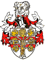 Arms of Westmorland County Council | |
| Subdivisions | |
| • Type | Baronies, Wards (ancient) |
Early history
At the time of Domesday Book in 1086, parts of the county were considered either to form part of Yorkshire or to be within the separate Kingdom of Strathclyde. The Normans conquered the area that is now Cumbria in 1092 during the reign of William II and created the baronies of Kendal and Westmorland. These were originally distinct jurisdictions with separate sheriffs, but were formed into a single county of Westmorland in 1226/7.[7] Before 1226 the Barony of Kendal was connected to the Earldom or Honour of Lancaster while that of Westmorland was part of the Earldom of Carlisle.
The historic county boundaries are with Cumberland to the north, County Durham and Yorkshire to the east, and Lancashire to the south and west. Windermere forms part of the western border with Lancashire north of the sands, and Ullswater part of the border with Cumberland.
The highest point of the county is Helvellyn at 3,117 ft (950m). According to the 1831 census the county covered an area of 485,990 acres (1,966.7 km2).[1]
Appleby, the historic county town, formed a historic borough and was not reformed by the Municipal Corporations Act 1835, although reform came in 1885. Kendal was reformed as a municipal borough in 1835.
Division into wards
Rather than being divided into hundreds, Westmorland was subdivided into the two baronies of Westmorland (or sometimes Appleby) and Kendal.
The baronies were each further subdivided into two wards:
Modern history
In 1889, under the Local Government Act 1888, a county council was created for Westmorland, taking functions from the Quarter Sessions. Westmorland had no county boroughs throughout its history, so the administrative county, the area under the control of the county council, was coterminous with the geographic county. The county council was based at Kendal, rather than the historic county town of Appleby.
Aside from the two municipal boroughs of Kendal and Appleby, the Local Government Act 1894 divided the county into urban districts and rural districts:
- 5 Urban Districts: Ambleside, Bowness on Windermere, Grasmere, Kirkby Lonsdale, Windermere
- 3 Rural Districts: West Ward, East Westmorland, South Westmorland
In 1905 a new Shap urban district was formed, while Windermere absorbed the neighbouring Bowness UD.
A County Review Order in 1935 reduced the number of districts in the county:
- A new Lakes Urban District was formed by the merger of Ambleside and Grasmere UDs and adjacent parishes in West Ward and South Westmorland RDs
- East Westmorland RD, most of West Ward RD and Shap UD were merged to form North Westmorland Rural District
- South Westmorland RD absorbed Kirkby Lonsdale UD, at the same time losing an area to Lakes UD.[7]
Despite their title, many of Westmorland's urban districts, such as Lakes, Grasmere, and Shap, were quite rural in character.
According to the 1971 census, Westmorland was the second least populated administrative county in England, after Rutland. The distribution of population was as follows:[12]
| District | Population |
|---|---|
| Municipal Borough of Appleby | 1,944 |
| Municipal Borough of Kendal | 21,602 |
| Lakes Urban District | 5,815 |
| Windermere Urban District | 8,065 |
| North Westmorland Rural District | 14,778 |
| South Westmorland Rural District | 20,633 |
In 1974, under the Local Government Act 1972, the county council was abolished and its former area was combined with Cumberland and parts of Lancashire and Yorkshire to form the new county of Cumbria, administered by a new Cumbria County Council.[13] The area now forms parts of the districts of South Lakeland and Eden.
Coat of arms
Westmorland County Council was granted a coat of arms by the College of Arms in 1926. The design of the shield referred to the two components of the county: on two red bars (from the arms of the de Lancaster family, Barons of Kendal) was placed a gold apple tree (from the seal of the borough of Appleby, for the Barony of Westmorland). The crest above the shield was the head of a ram of the local Herdwick breed. On the ram's forehead was a shearman's hook, a tool used in the handling of wool. The hook was part of the insignia of the borough of Kendal, the administrative centre of the county council.[14]
Legacy

Westmorland is still used as a place name by organisations and businesses in the area such as:
- The Westmorland Gazette (founded 1818)
- The Westmorland County Agricultural Society (founded 1799), which organises the annual Westmorland County Agricultural Society Show
- The Westmorland County Football Association, the regional division of the Football Association that administers many football leagues including the Westmorland Association Football League.
- The Westmorland Geological Society (formed 1973)
- The Cumberland and Westmorland Antiquarian and Archaeological Society (founded 1866)
- The Westmorland Youth Orchestra
- The Westmorland Shopping Centre, Kendal
- The Westmorland Cricket League
- Westmorland Motorway Services, the company behind Tebay services in Westmorland and Gloucester Services.
- In 1974 the successor parish council formed for the former borough of Appleby adopted the name Appleby-in-Westmorland.
- Westmorland General Hospital in Kendal
- Westmorland croquet club
The southern part of the county, the former Barony of Kendal or that part of Westmorland that is part of South Lakeland, is included in the Westmorland and Lonsdale parliamentary constituency.
In June 1994, during the 1990s UK local government reform, the Local Government Commission published draft recommendations suggesting that Westmorland's border with Yorkshire and Lancashire be restored for ceremonial purposes. The final recommendations, published in October 1994, did not include such recommendations, apparently due to lack of expression of support for the proposal to the commission.
In September 2011, the Westmorland Association, a local society which promotes the county's identity, successfully registered the Flag of Westmorland with the Flag Institute.
Notable people
- Sir Thomas Strickland carried the Flag of St. George at the battle of Agincourt.
- St. John Boste, Roman Catholic priest and martyr
- Mary Wakefield, patron of music celebrated with annual Mary Wakefield Festival[15]
- Nicholas Freeston (1907-1978), award-winning Lancashire poet, born in Kendal
- George Romney, portrait painter, many paintings by him at Kendal Town Hall
- William Parr, 1st Baron Parr of Kendal who was father to Sir Thomas Parr of Kendal and thus the grandfather of Queen Catherine Parr, Henry VIII's sixth wife. The Parr's ancestral castle, Kendal Castle, is located in Kendal.
- Tom Barker, trade unionist and socialist, born in Crosthwaite
- Margaret Cropper, poet
See also
- List of Lord Lieutenants for Westmorland
- List of High Sheriffs for Westmorland
- Custos Rotulorum of Westmorland - List of keepers of the Rolls
- Westmorland (UK Parliament constituency) - List of MPs for constituency of Westmorland
- Västmanland - Swedish historic county
References
- 1831 Census cited in Vision of Britain - Ancient county data
- Vision of Britain - Westmorland population (density and area)
- "Eric Pickles: celebrate St George and England's traditional counties". Department for Communities and Local Government. 23 April 2013. Retrieved 22 June 2013.
- Kelner, Simon (23 April 2013). "Eric Pickles's championing of traditional English counties is something we can all get behind". London: The Independent. Retrieved 22 June 2013.
- Garber, Michael (23 April 2013). "Government 'formally acknowledges' the Historic Counties to Celebrate St George's Day". Association of British Counties. Retrieved 22 June 2013.
- R. Wilkinson The British Isles, Sheet The British Isles. Vision of Britain
- F.A. Youngs, Guide to the Local Administrative units of England, Vol.II, Northern England, London, 1991
- Vision of Britain - History of East ward
- Vision of Britain - History of West ward
- Vision of Britain Archived 2011-08-14 at the Wayback Machine - History of Kendal ward
- Vision of Britain Archived 2007-10-01 at the Wayback Machine - History of Lonsdale ward
- 1971 Census; Small Area Statistics
- "Local Government Act 1972". www.legislation.gov.uk. Retrieved 2018-08-17.
- W.C. Scott-Giles, Civic Heraldry of England and Wales, 2nd edition, London, 1953
- "The history of the festival". Retrieved 22 January 2014.
External links
- The Westmorland Association
- Map of Westmorland on Wikishire