Tri-State Tornado
The Tri-State Tornado was a deadly and destructive tornado that struck parts of three states in the Central United States on the afternoon of Wednesday, March 18, 1925. The most exceptional of at least 12 significant tornadoes produced by a major tornado outbreak that spanned a large portion of the Midwestern and Southern United States, the Tri-State Tornado killed at least 695 people,[1] making it by far the deadliest tornado in United States history and the second-deadliest in world history.[2] The 151-to-235-mile (243 to 378 km) track left by the tornado, as it crossed from southeastern Missouri, through southern Illinois, and then into southwestern Indiana, is also the longest ever recorded.[3]
| F5 tornado | |
|---|---|
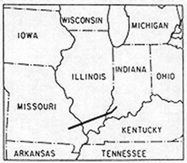 The path of the Tri-State Tornado. The storm covered a distance of over 219 miles (352 km) in its 3½-hour lifetime, traveling at forward speeds in excess of 70 miles per hour (110 km/h). | |
| Formed | March 18, 1925 1:01 PM CST (UTC−06:00) Shannon County, Missouri |
| Duration | 3 hours, 37 minutes |
| Dissipated | March 18, 1925 4:38 PM CST (UTC−06:00) Petersburg, Indiana |
| Max. rating1 | F5 tornado |
| Highest winds |
|
| Damage | $2.2 billion (2019 USD) |
| Casualties | 695 fatalities 2,027 injuries |
| Areas affected | Southern Missouri, Illinois, Indiana |
| 1Most severe tornado damage; see Fujita scale | |
Modern meteorological re-analysis has suggested that the extremely long path length and lifespan reported in historical accounts are perhaps more plausibly attributed to multiple independent tornadoes belonging to a tornado family, rather than a single, continuous tornado.[4] Although not officially rated by NOAA, the Tri-State Tornado is recognized by most experts (such as Tom Grazulis[5] and Ted Fujita[6]) as an F5 tornado, the maximum damage rating issued on the Fujita scale.[7]
Path and damage
Missouri
The tornado was first sighted as a highly visible and relatively small condensation funnel in the rugged forested hills of Moore Township, Shannon County, Missouri, at about 1:00 PM Central Time.[3] The first fatality occurred around 1:01 PM, when a farmer was caught off-guard north-northwest of Ellington in Reynolds County.
The tornado sped to the northeast, moving into Iron County and hitting the mining town of Annapolis. Within a matter of minutes, two people were killed and 90 percent of the town was leveled. The tornado then struck the mining town of Leadanna, where mining machinery and several structures were destroyed.[8] It then crossed into the sparsely populated areas of Madison County south of Fredericktown, where near Cherokee Pass the tornado steadily began to grow larger.[9]
In Bollinger County, 32 children were injured when two schools were damaged. Multiple homes and farms were completely destroyed near Lixville, where a farmer and two children were killed, and a third child died from her injuries one week after the storm. Deep ground scouring was observed near the town of Sedgewickville as well. The tornado carried sheets of iron as far as 50 mi (80 km) away.
Crossing into Perry County, the tornado reportedly developed a double funnel as it struck the town of Biehle, destroying many homes in and around the town and killing two people. At Brazeau, another farmer was gravely injured and died four days later. Numerous other homes and farms were completely leveled near Frohna as well, where one woman was killed and another died from her injuries ten days later.[8][10] Altogether, at least 12 people (possibly more) died and another 200 were injured in Missouri.[11]
Illinois

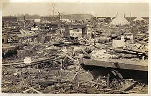
The tornado then crossed the Mississippi River into southern Illinois, debarking trees and deeply scouring the ground in rural areas before hitting the riverside town of Gorham at 2:30 PM, essentially obliterating the entire town. Almost every structure in Gorham was leveled or swept away, and railroad tracks were reportedly ripped from the ground.[8] More than half the town's population was injured or killed; 30 were killed in the immediate storm and six of those injured later succumbed to their wounds.[12]
Continuing to the northeast at an average speed of 62 mph (100 km/h) (and up to 73 mph (117 km/h)), the tornado cut a swath almost 1 mi (1.6 km) wide through the city of Murphysboro, completely flattening a large portion of the northern side of the city. Entire rows of homes were leveled and swept away in some areas.[13] Many other structures were also damaged or destroyed throughout the town, including the M&O railroad shop, where 35 people were killed. Schools in the area were devastated as well, with 17 students killed at the Longfellow School and 9 others killed at the Logan School.[8] After the tornado passed, large fires ignited and swept through the rubble, burning many of the trapped survivors alive. Among the scores of injured from Murphysboro, at least 30 later died from their injuries, and many of those among the dead were never identified.[14] In Murphysboro, a total of 234 were killed, the greatest loss of life from a tornado in a single city in U.S. history.
The tornado then struck the nearby town of De Soto, which was also devastated; 69 people were killed there, and many homes were swept away. 33 of the deaths were students that were killed in the partial collapse of the De Soto School, the worst tornadic death toll at a single school in U.S. history.[14] Also killed at De Soto was Jackson County Deputy Sheriff George Boland. While on patrol when the storm struck, the tornado lifted him from the ground and he disappeared into the funnel. His body was never found.[15]
After exiting De Soto, the tornado clipped the northwest corner of Williamson County, narrowly missing the town of Hurst and striking the small village of Bush. Several homes were leveled, and pieces of wood were speared into the town's water tower. Heavy railroad axles were reportedly lifted and scattered across the railyard.[14] The tornado killed 10 people in Bush and the surrounding area, while three of those injured later died from their wounds.
Further east, the tornado crossed into Franklin County, where the mining town of West Frankfort was also devastated by the massive tornado. The tornado struck the northwest side of town, leveling many businesses and sweeping away entire subdivisions.[8] At the Orient Mine, a large multi-ton coal tipple was blown over and rolled by the tornado. Extreme damage continued east of town, as a railroad trestle was torn from its supports, and 300 ft (91 m) of railroad track was ripped from the ground and blown away. Several small mining villages in the area were obliterated, resulting in numerous fatalities.[13] The tornado then destroyed the small town of Parrish, which was never rebuilt. In all, the storm claimed 192 lives in Franklin County: 155 in the immediate storm and another 37 of the injured in the following weeks. At West Frankfort, 95 people died in the immediate storm, while 19 later died from their injuries. At Parrish, 17 died when the tornado swept the village away, and three of the injured later succumbed to their wounds. In the rural areas both east and west of West Frankfort, the tornado claimed another 43 lives, with another 15 later dying from their injuries.
The tornado proceeded to devastate additional rural areas across Hamilton and White counties, claiming 65 more residents. As the tornado charged across Hamilton County south of McLeansboro, the tornado reached its greatest width at 1.5 miles (2,400 m). Dozens of farms and homes were swept away, 28 people were killed, and nine more of those injured later died from their wounds. In White County the tornado passed just two miles north of Carmi, missing the towns of Enfield and Crossville by barely a mile each. Another 17 were killed and 11 of those injured later succumbed to their injuries.
Indiana
Crossing the Wabash River just north of New Harmony, the tornado then entered Indiana. Grazing the northernmost edge of Posey County, the tornado struck and completely demolished the town of Griffin, where most structures were leveled, and some were swept away; 46 people were killed at Griffin and in the surrounding areas.
After exiting Griffin, the tornado made a slight turn towards the northeast as it crossed into Gibson County, devastating rural areas and clipping the northwest corner of Owensville, resulting in nine fatalities. The tornado then roared into the factory town of Princeton, destroying much of the southern side of the town and killing 38 people. Large sections of neighborhoods in Princeton were leveled, and a Heinz factory was badly damaged.[8] The tornado traveled more than 10 mi (16 km) to the northeast, crossing into Pike County before finally dissipating at about 4:38 PM around 2.5 mi (4.0 km) south-southeast of Petersburg. In Indiana, at least 95 (and probably more) perished.[16]
Aftermath

In the immediate aftermath, hospitals from St. Louis to Evansville were inundated with the injured and dying, as the storm injured more than 2,000 people, 105 of whom later died from their injuries. In Missouri, relief trains carried the most seriously injured north to St. Louis, while the remainder were sent to hospitals at Perryville and Cape Girardeau. At Gorham, where half the town's population was injured, the Missouri Pacific Railroad shuttled most of the injured north to East St. Louis, and the remainder south to Cairo.[17]
The town hospital in Murphysboro, where over 1,000 were injured, was ill-equipped to deal with the casualties, prompting hundreds to be shipped out to other towns by train once the lines were cleared. Several hundred were taken to Carbondale, while many more were taken into both St. Louis and East St. Louis.[18] The storm claimed its final victim on January 3, 1926, when Gervais Burgess, a 46-year-old coal miner from West Frankfort, died from injuries sustained in the tornado.[19]
In the end, a total of 695 were confirmed dead – 12 in Missouri, 95 in Indiana and 588 in Illinois. Three states, 14 counties, and more than 19 communities, four of which were effectively effaced (several of these and other rural areas never recovered), were in the path of the tornado, which had lasted a record duration of three and a half hours. Approximately 15,000 homes were destroyed by the Tri-State Tornado.[20] Total damage was estimated at $16.5 million in 1925 dollars; adjusted for increases in population/wealth and inflation, the toll is approximately $1.4 billion (1997 USD), surpassed only by two extremely destructive tornadoes, both in the City of St. Louis, in 1896 and 1927.[21]
Nine schools across three states were destroyed, in which 69 students were killed. More schools were destroyed and more students killed (as well as the single school record of 33 deaths in De Soto, Illinois) than in any other tornadic event in U.S. history.[7] Deaths occurred at many rural schools. Counting those returning home from schools and those that died in schools, the toll was 72 students.[12] Approximately one-third of the tornado's victims were children.
The very strong tornado – modern meteorologists estimate that its wind speeds topped 300 miles per hour (480 km/h) in some locations – at times exhibited an unusual appearance due partially to its size (at one point in Missouri, it was a full mile wide) and the probable low cloud base of its parent thunderstorm.[22] The tornado was frequently described by witnesses as an amorphous rolling fog or boiling clouds on the ground, and fooled normally weather-wise farm owners (in addition to people in general) who did not sense the danger until the storm was upon them. The condensation funnel was also reportedly sometimes wrapped in copious dust and debris, which likely obscured it and made it less recognizable. The parent supercell apparently transitioned to a high-precipitation (HP) variety by the time it struck West Frankfort, meaning that the tornado was not readily visible, as it was often shrouded in heavy rain and hail. The rural death toll of 65 in Hamilton and White counties in southeastern Illinois is unprecedented. The tornado killed at least 20 farm owners in southeastern Illinois and southwestern Indiana, more than the combined total of the next four deadliest tornadoes in the history of the United States.[12]
The tornado was often accompanied by extreme downburst winds throughout the entirety of its course; the accompanying downburst periodically increased the width of the damage path from the overall average of 0.75 mi (1.21 km), varying from 1 mi (1.6 km) to 3 mi (4.8 km) wide at times.[7]
In addition to the dead and injured, thousands were left without shelter or food. Fires erupted, growing to conflagrations in some places, exacerbating the damage.[23] Looting and theft, notably of the property of the dead, was reported. Recovery was generally slow, with the event leaving a lasting blow to the region.
Meteorological synopsis
.jpg)
During a six-year review study of the Tri-State Tornado published in 2013, new surface and upper air data was obtained and meteorological reanalysis was utilized, adding significantly to knowledge of the synoptic and even mesoscale background of the event. The late winter to early spring of 1925 was warmer and drier than normal over much of the central United States. There apparently was persistent ridging in the western U.S. with a troughing pattern over the central U.S.[4]
The extratropical cyclone that set the synoptic stage for the outbreak was centered over northwestern Montana at 7 AM CST on March 17. Meanwhile, a diffuse area of surface low pressure was centered near Denver, Colorado, in association with a lee trough. Occluded fronts extended from Hudson Bay southwestward into the northern Plains states and into the lee trough. The synoptic cyclone moved south-southeastward across the mountain states to eastern Colorado. A warm front stretched along the Gulf Coast, separating warm, moist air from cool, showery weather with areas of fog that extended from Texas to the Carolinas. A well-mixed early-season continental tropical (cT) air mass existed over West Texas and northern New Mexico. To the east of this hot, dry air, buoyant maritime tropical (mT) air was advecting from the Gulf of Mexico. Simultaneously, a mid- to upper-level shortwave trough likely approached the northwest coast of the U.S. and moved rapidly through the persistent ridge then digging southeastward across the Great Basin and central Rocky Mountains and emerging in the Plains over Colorado. This initiated a "Colorado low" cyclogenesis.[4]
At 7 AM on March 18, the surface low-pressure area, at approximately 1,003 hPa (29.6 inHg), moved to far northeastern Oklahoma while the warm front shot north into the circulation where the front then extended eastward. A maritime Polar (mP) cold front draped southwestward across eastern Texas with a dry line forming due south of the low. The open shortwave, likely somewhat negatively tilted, was continuing to approach from the northwest and an apparent outflow boundary moved just south of the warm front over northeastern Arkansas and northwestern Tennessee. Several weak pressure troughs were traversing the cool sector over the north-central U.S. at the time. Surface temperatures in the warm sector near the dry line and warm front ranged from 65–75 °F (18–24 °C), and the dew point was 60–65 °F (16–18 °C), with higher values farther south and increasing over time as the deepening low-pressure area continued to pull up air from the Gulf of Mexico. This resulted in unstable air and lower cloud bases, or low LCL heights, which is favorable to tornadogenesis. From southeastern Kansas to Kentucky and Indiana, early morning showers and thunderstorms north of the low and warm front cooled and stabilized that air, retarding northward advancement of the front, and led to a sharp contrast in temperature from north to south. Such baroclinic zones are also associated with tornadic storms. Ahead of the surface dry line, which are uncommon as far east as the Mississippi River,[24] an apparent "dry punch" of air aloft served to further increase instability. Concurrently, a capping inversion likely suppressed storms throughout the warm sector, leaving the Tri-State supercell undisturbed by nearby convection.[4]
By 12 PM, the deepening surface low was centered over south-central Missouri, the shortwave axis was moving easterly and oriented over eastern Oklahoma, and the dry line was rapidly advancing eastward directly south of the low as the warm front, situated due east of the low, slowly shifted northward. Morning clouds cleared by midday across much of the Tri-State Tornado's eventual path. A pronounced pressure trough extended northeast of the low and signaled its future track as a prefrontal trough formed southeast of the low ahead of the dry line. A bulge in the dry line may also have been forming slightly south of the low, and southerly to southeasterly surface winds were backing and increasing with time throughout the warm sector. The Tri-State supercell formed in a highly favorable area just ahead of the triple point where the cold front, warm front, and dry line met. The supercell initiated very near the surface low and moved east-northeastward, faster than the low, such that the storm gradually deviated east of the low's track. The supercell remained near this "sweet spot" for a prolonged period as it also traveled near the highly baroclinic warm front (likely just across the cool side of the boundary) for several hours.[4]
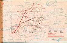
By 2 PM, the low was centered slightly south-southwest of St. Louis, Missouri, as the Tri-State supercell neared the Mississippi River. Other storms in the warm sector, removed from the Tri-State supercell, were initiating around 3 PM. Around 4 PM, the low's central pressure lowered to around 998 hPa (29.5 inHg), centered over south-central Illinois, as the supercell was moving into Indiana. This pressure is not particularly low compared to many other outbreak setups, but the pressure gradient was strong, which induced strong gradient winds and significant advection in the warm sector. A very strong low level jet was also in place just above the surface as winds veered with height, resulting in low-level curvature and long hodographs. Strong wind shear thus existed, with pronounced directional shear likely in the vicinity of the warm front, with winds at the 700 hPa height level west-southwesterly around 70 mph (110 km/h) and winds at the 500 hPa level about 90–110 mph (140–180 km/h). Theoretical hodographs returned estimated storm relative environmental helicity (SREH) values of 340 m2 s−2 in the vicinity of the Tri-State supercell track. Strong thunderstorms were now scattered throughout the warm sector and a line of severe thunderstorms was occurring near the dry line. The Tri-State supercell appeared to still be discrete and isolated, with a severe storm north of Cairo, Illinois, placed well to its south.[4]
By 6 PM, the shortwave axis was over eastern Missouri and was lifting northeast. At 7 PM, the low was placed near Indianapolis, Indiana, with numerous thunderstorms east and south of the low and a squall line moving into the southeastern U.S. Cold air advection behind the strong cold front fed into the cyclone as snow and sleet fell from eastern Iowa to central Michigan. At 7 AM on March 19, the low was deepening and lifting rapidly northeastward into Canada.
The Tri-State supercell is thought to have formed around noon on March 18, about 40 minutes prior to the first tornado reports in Shannon County. It was a classic supercell for the first couple hours of its life, gradually transitioning into a high-precipitation (HP) supercell in southern Illinois. The very long track tornado period lasted from around 12:40 PM to 4:40 PM. The supercell then likely produced another significant tornado in southeastern Indiana around 6 PM. Convection had gradually increased in the warm sector throughout the supercell's life cycle. It may have become embedded within a line echo wave pattern (LEWP) by the time it reached south-central Indiana. The supercell is assumed to have decayed around 7 PM. These estimated times indicate the supercell's duration as around 7 hours over a calculated path of approximately 413 mi (665 km).[3][4]
Controversy
There has long been uncertainty as to whether the originally recognized reports of a 219-mile (352 km) path over 3.5 hours represent a single continuous tornado or multiple independently tracking tornadoes belonging to a tornado family. Because of the scarcity of verifiable meteorological data from the time of the event and the apparent absence of any record of a tornado having approached this path length and duration in the years since, doubts have been raised about the plausibility of the conclusion that a single tornado was responsible for them.
Modern meteorological theory regarding tornado and supercell morphology and dynamics suggests that a single tornado lasting for such a duration is highly improbable.[4] Several other historical accounts of very long track (VLT) tornadoes have subsequently been determined to be the product of tornado families[26] (notably the Charleston-Mattoon, Illinois tornado family of May 1917 and the Woodward, Oklahoma tornado family of April 1947). In more recent years, some VLT tornadoes and supercells have indeed occurred, with 12 tornadoes exceeding 100-mile (160 km) path lengths from 1980–2012, and 60 since 1950.[3] Yet the high-end estimates of the Tri-State Tornado path length are still about twice as long as the nearest verified VLT tornado. On the other hand, meteorological analysis reveals no record of any analogous mesoscale circumstances in recent history, meaning that the weather conditions which led to the Tri-State Tornado were apparently unique.
In 2001, tornado expert Tom Grazulis wrote that the first 60 miles (97 km) of the track was probably the result of two or more tornadoes, and that a 157-mile (253 km) segment of the overall path length was seemingly continuous.[12] No single factor accounts for the exceptional path length and duration, though the fast forward motion of the tornado, which averaged 59 mph (95 km/h), may have translated to more distance covered.[4]
Exhaustive research published in 2013 found no definitive resolution, but did locate additional tornado sightings and damage 15 mi (24 km) west of the previously known beginning of the tornado and 1 mi (1.6 km) east of the previously known ending, extending the total path length by 16 miles to 235 mi (378 km) long. The scientists concluded it is likely that at least some of the track, both at the beginning and ending, was indeed caused by separate tornadoes. They also located a 20 mi (32 km) path (apparently created within a period of about 20 minutes) from a large tornado which was likely spawned from the same supercell and was about 65 mi (105 km) east-northeast of the aforementioned path ending. This brings the known length of the Tri-State Tornado family to around 320 mi (510 km) over nearly 5.5 hours. The 2013 study concludes that it is likely that the 174 mi (280 km) segment from central Madison County, Missouri to Pike County, Indiana, was the result of one continuous tornado, and that the 151 mi (243 km) segment from central Bollinger County, Missouri to western Pike County, Indiana, was very likely the result of a single continuous tornado.[3] Either of these two values still holds the record for the longest recorded tornado track.
Wider tornado outbreak
| Type | Tornado outbreak |
|---|---|
| Duration | Wednesday, March 18, 1925 |
| Tornadoes confirmed | 12 known |
| Max. rating1 | F5 tornado |
| Duration of tornado outbreak2 | 7 hours |
| Largest hail | 4.5 inches (11 cm) at Lexington, Kentucky at 7:15 PM CST[4] |
| Damage | Unknown; at least $1.4 billion (1997 USD)[21] |
| Casualties | 747+ fatalities 2,298+ injuries[7] |
| Areas affected | Midwestern and Southeastern United States |
| 1Most severe tornado damage; see Fujita scale 2Time from first tornado to last tornado | |
| FU | F0 | F1 | F2 | F3 | F4 | F5 | Total |
|---|---|---|---|---|---|---|---|
| ≥3 | ? | ? | 2 | 4 | 2 | 1 | ≥12 |
The Tri-State tornado was part of a larger tornado outbreak which generated several other destructive tornadoes in Tennessee, Kentucky, and Indiana on the same day, as well as significant tornadoes in Alabama and Kansas. By all accounts it was a widespread outbreak with severe thunderstorms occurring as far east as Ohio, as far southwest as Louisiana, and as far southeast as Georgia. Strong thunderstorms were reported in a broad area that also included parts of Oklahoma, Michigan, Pennsylvania, West Virginia, and Ontario. Numerous reports of hail and straight-line winds were reported, with up to 4.5 in (11 cm) diameter hail recorded (by comparison, a softball is 3.5–3.8 in (8.9–9.7 cm) in diameter[27]). What began in the early afternoon as discrete supercell thunderstorms eventually consolidated into a potent squall line.[4]
Including the additional tornadoes that day, at least 747 people were killed and more than 2,298 were injured. This makes the Tri-State Tornado outbreak the deadliest tornado outbreak, March 18 the deadliest tornado day, and 1925 the deadliest tornado year in U.S. history.[28] There were undoubtedly other tornadoes with lesser impacts, the occurrences of which have been lost to history.[7]
| List of significant tornadoes — March 18, 1925 | ||||||
|---|---|---|---|---|---|---|
| Kansas | ||||||
| F2 | Dearing | Montgomery | 0510 | unknown | Homes and gas station damaged at and around Dearing. | |
| Tri-State (Missouri, Illinois, Indiana) | ||||||
| F5 | WNW of Ellington, Missouri to 2.5 mi (4.0 km) SSE of Petersburg, Indiana | Shannon; Reynolds; Iron; Madison; Bollinger; Perry; Jackson, IL; Williamson, IL; Franklin, IL; Hamilton, IL; White, IL; Posey, IN; Gibson, IN; Pike, IN | 1240 | 235 mi (378 km)[3] | 695 deaths - Deadliest single tornado in US history - See section on this tornado - Very long track multiple-vortex tornado was likely accompanied by satellite tornadoes at times, with path segments at the beginning and end possibly from separate tornadoes comprising a tornado family;[3][4][12] 1,200 yd (1,100 m) average path width. 2,027 others were injured.[7] | |
| Alabama | ||||||
| F2 | Littleville | Colbert | 1642 | 12 mi (19 km) | 1 death - Tornado moved northeast in Littleville where damage and casualties at a gas station, homes, and a store occurred; 60 yd (55 m) average path width. 12 others were injured. | |
| Tennessee | ||||||
| F4 | Near Buck Lodge, Tennessee to Beaumont, Kentucky | Sumner; Allen, KY; Barren, KY; Monroe, KY;, Metcalfe, KY | 1700 | 60 mi (97 km) | 39 deaths - Moved ENE from 8 mi (13 km) north of Gallatin, Tennessee. Homes and churches were leveled in many communities, and some were swept away. Possibly a tornado family; 400 yd (370 m) average path width. 95 others were injured. | |
| F3 | Kirkland | Williamson; Rutherford | 1745 | 20 mi (32 km) | 1 death - Major damage to homes in Kirkland incurring all casualties; 200 yd (180 m) average path width. Nine others were injured. | |
| F3 | Near Unionville to 2 mi (3.2 km) NE of Fosterville | Bedford; Rutherford | 1810 | 12 mi (19 km) | 2 deaths - Moved ENE, at least 10 homes destroyed; 300 yd (270 m) average path width. 15 others were injured. | |
| Indiana | ||||||
| F4 | Mauckport, Indiana to southern border of Louisville, Kentucky | Harrison; Jefferson, KY | 1715 | 18 mi (29 km) | 4 deaths - Up to 1 mi (1.6 km) wide, moved ENE, swept away entire farms near Laconia and Elizabeth, Indiana before ending just south of Louisville, Kentucky; 1,200 yd (1,100 m) average path width. 60 others were injured | |
| ? | Monroe Township to Vernon Township | Washington, Jackson | ~1746 | 20 mi (32 km) | Likely a continuation of the Tri-State Tornado Family. Large tornado in rural areas caused significant damage to homes and a church; some houses flattened. Several injuries.[3] | |
| Kentucky | ||||||
| F3 | Louisville to near Pewee Valley | Jefferson; Oldham | 1800 | 10 mi (16 km) | ≥3 deaths - Moved NE from east edge of Louisville to near Pewee Valley; at least 12 homes destroyed. 40 others were injured, and the death toll may have been higher. | |
| F3 | Western Marion County to Lexington, Kentucky area | Marion; Washington; Mercer; Jessamine; Fayette; Bourbon | 1830 | 60 mi (97 km) | 2 deaths - Tornado family moved ENE from western Marion County, passing near Springfield, and ending past Lexington; 300 yd (270 m) average path width. 40 others were injured. | |
| Source:[7] | ||||||
See also
| Wikimedia Commons has media related to Tri-State Tornado. |
- List of North American tornadoes and tornado outbreaks
- List of tornado-related deaths at schools
- List of F5 and EF5 tornadoes
- Daulatpur–Saturia tornado, the deadliest tornado worldwide in recorded history
References
- Gibson, Christine (Aug–Sep 2006). "Our 10 Greatest Natural Disasters". American Heritage. 57 (4).
- Tri-State Tornado - History, Facts and Information
- Johns, Robert H.; D. W. Burgess; C. A. Doswell III; M. S. Gilmore; J. A. Hart; S. F. Piltz (2013). "The 1925 Tri-State Tornado Damage Path and Associated Storm System". e-Journal of Severe Storms Meteorology. 8 (2).
- Maddox, Robert A.; M. S. Gilmore; C. A. Doswell III; R. H. Johns; C. A. Crisp; D. W. Burgess; J. A. Hart; S. F. Piltz (2013). "Meteorological Analyses of the Tri-State Tornado Event of March 1925". e-Journal of Severe Storms Meteorology. 8 (1).
- Grazulis, Thomas P. (2001). F5/F6 Tornadoes. St. Johnsbury, VT: The Tornado Project of Environmental Films.
- Fujita, T. Theodore (1973). "Tornadoes Around the World". Weatherwise. 26 (2): 56–83. doi:10.1080/00431672.1973.9931633.
- Grazulis, Thomas P. (July 1993). Significant Tornadoes 1680-1991: A Chronology and Analysis of Events. St. Johnsbury, VT: The Tornado Project of Environmental Films. ISBN 1-879362-03-1.
- Schuman, Shawn (June 10, 2013). "March 18, 1925 — The Tri-State Tornado". Retrieved 2014-03-25.
- Johns, Robert H, p. 7–9
- Grazulis, Tom (2013). "#1: The Tri-State Tornado". Descriptions of the Top Ten US Killer Tornadoes. The Tornado Project. Archived from the original on 2013-10-31. Retrieved 2014-03-25.
- St. Louis Post-Dispatch, March 20, 1925, p. 3
- Grazulis, Thomas P. (2001). The Tornado: Nature's Ultimate Windstorm. Norman, OK: University of Oklahoma Press. ISBN 0-8061-3258-2.
- Johns, Bob (2012). The 1925 Tri-State Tornado's Devastation In Franklin County, Hamilton County, And White County, Illinois. Bloomington, IN: AuthorHouse. ISBN 978-1468560961.
- Mason, Angela (2011). Death Rides the Sky: The Story of the 1925 Tri-State Tornado. Rockford, IL: Black Oak Media. ISBN 978-1-61876-001-2.
- Partlow, Geoff. 'America's Deadliest Twister', p. 60–61
- "Tornado Track". 1925 Tri-State Tornado: A Look Back. NWS Paducah. Retrieved 2013-04-01.
- Partlow, Geoff. p. 24
- Partlow, Geoff. p. 42–44
- Johns, Bob. 'The 1925 Tri State Tornado's devastation in Franklin County, White County, and Hamilton County, Illinois', p. 20–21
- "Startling Statistics". NWS Paducah. 1925 Tri-State Tornado: A Look Back. Retrieved 2019-05-04. Check date values in:
|date=(help) - Brooks, Harold E.; C. A. Doswell (February 2001). "Normalized Damage from Major Tornadoes in the United States: 1890–1999". Weather Forecast. 16 (1): 168–176. Bibcode:2001WtFor..16..168B. doi:10.1175/1520-0434(2001)016<0168:NDFMTI>2.0.CO;2.
- Blakemore, Erin. "The Deadliest Tornado in U.S. History Blindsided the Midwest in 1925". HISTORY. Retrieved 2019-04-08.
- Hottensen, Chris (March 22, 2015). "Survivors remember Tri-state Tornado 90 years later". The Southern Illinoisan. Retrieved 2019-05-04.
- Duell, Rebecca S.; M. S. Van Den Broeke (2016). "Climatology, Synoptic Conditions, and Misanalyses of Mississippi River Valley Drylines". Mon. Wea. Rev. 144 (3): 927–43. Bibcode:2016MWRv..144..927D. doi:10.1175/MWR-D-15-0108.1.
- NOAA Photo Library
- Doswell, Charles A., III; D. W. Burgess (1988). "On Some Issues of United States Tornado Climatology". Mon. Wea. Rev. 116 (2): 495–501. Bibcode:1988MWRv..116..495D. doi:10.1175/1520-0493(1988)116<0495:OSIOUS>2.0.CO;2.
- http://www.softballperformance.com/what-is-the-diameter-of-a-softbal/
- "2011 tornado information". National Oceanic and Atmospheric Administration. 2012. Archived from the original on 2011-06-06. Retrieved 2014-03-25.
- Flora, Snowden D. (1953). Tornadoes of the United States. Norman, OK: University of Oklahoma Press. ISBN 978-0806102627.
Further reading
- Felknor, Peter S. (1992). The Tri-State Tornado: The Story of America's Greatest Tornado Disaster. Ames, IA: Iowa State University Press. ISBN 0-8138-0623-2.
- Akin, Wallace E. (2002). The Forgotten Storm: The Great Tri-state Tornado of 1925. Guilford, CT: Lyons Press. ISBN 1-58574-607-X.
- Partlow, Geoff (2014). America's Deadliest Twister: The Tri-State Tornado of 1925. Carbondale, IL: Southern Illinois University Press. ISBN 9780809333462.
External links
- 1925 Tri-State Tornado (NWS Paducah, KY)
- The Weather Channel's Storm of the Century list – #7 The Tri-State Tornado
- The Great Tri-State Tornado (RootsWeb Genealogy)
- The 1925 Tornado (Carolyar.com Genealogy)
- aerial film of damage path
- 'The 1925 Tri-State Tornado Damage Path Analysis' By R.H. Johns & Associates
| Preceded by Lorain & Sandusky, Oh. (1924) |
Costliest U.S. tornadoes on Record March 18, 1925 |
Succeeded by St. Louis, Mo. & E. St. Louis, Ill. (1927) |