Thames Barrier
The Thames Barrier is a movable barrier system that is designed to prevent the floodplain of most of Greater London from being flooded by exceptionally high tides and storm surges moving up from the North Sea. It has been operational since 1982. When needed, it is closed (raised) during high tide; at low tide it can be opened to restore the river's flow towards the sea. Built approximately 3 km (1.9 mi) due east of the Isle of Dogs, its northern bank is in Silvertown in the London Borough of Newham and its southern bank is in the New Charlton area of the Royal Borough of Greenwich.
| Thames Barrier | |
|---|---|
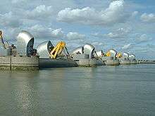 View of the barrier gates, which are closed when a flood warning is issued | |
| Country | United Kingdom |
| Location | London |
| Coordinates | 51°29′49″N 0°2′12″E |
| Purpose | Flood control |
| Status | Operational |
| Construction began | 1974 |
| Opening date | 1982 |
| Construction cost | £534 million |
| Built by |
|
| Operator(s) | Greater London Council |
| Dam and spillways | |
| Type of dam | Barrage |
| Impounds | River Thames |
| Height (thalweg) | 20.1 metres |
| Length | 520 metres |
| Operator(s) | Environment Agency |
| Turbines | 0 |
| Website gov.uk Guidance: The Thames Barrier | |

History
Background
Flooding in London has been a problem since the city was first established in Roman times.[1] In 1954 the Waverley Committee, established to investigate the serious North Sea flood of 1953 which affected parts of the Thames Estuary and parts of London, recommended that "as an alternative to raising the banks, the possibility and cost of erecting a structure across the Thames which could be closed in a surge should be urgently investigated".[2] A large number of designs were put forward, ranging from a huge road viaduct with two 500 foot (150 m) sluice gates crossing the Thames at Crayfordness to flap gates lying on the river bed and floated up by compressed air.[3] By 1965, when the Greater London Council (GLC) took over responsibility, two major schemes were under consideration, costed at £24 million and £41 million respectively[3] (£500 million and £800 million at 2020 prices).
In 1966 Sir Hermann Bondi was asked to take an independent view of the situation. He considered the estimated construction costs and the probability of a flood and of damage if the barrier was not built. He strongly recommended that a barrier should be built in order to avoid the catastrophe of flooding central London, and a site was agreed at Woolwich.[3]
The barrier protects central London against a storm surge, caused when a deep depression forms to the north of Scotland and progresses across the North Sea and south-easterly towards southern Scandinavia. When such a surge coincides with a high spring tide, the high winds associated with the depression can funnel the water up the Thames Estuary and cause surges of up to 3.5 metres. The planners assessed that in the absence of a barrier, such a surge could inundate 45 square miles (117 km2) of land, put hospitals, powers stations and the London Underground out of action and cause damage estimated in 1966 at £2.0 billion[4] (about £50 billion at 2020 prices). The barrier was designed to provide a flood defence capable of resisting a once in 1000 year surge tide at a base date of 2030.
Design and construction
The concept of the rising sector gates was devised by (Reginald) Charles Draper. In 1969, from his parents' house in Pellatt Grove, Wood Green, London, he constructed a working model. The novel rotating cylinders were based on the design of the taps on his gas cooker. The barrier was designed by Rendel, Palmer and Tritton for the Greater London Council and the concept tested at the Hydraulics Research Station, Wallingford[1]. The site at New Charlton was chosen because of the relative straightness of the banks, and because the underlying river chalk was strong enough to support the barrier.
The Thames Barrier and Flood Prevention Act, authorising construction, was passed in 1972. In 1974 the GLC placed the two major construction contracts. Civil construction was undertaken by a Costain/Hollandsche Beton Maatschappij/Tarmac Construction consortium.[3] A separate contract for the gates and operating machinery was placed with the Davy Cleveland Barrier Consortium[3], formed by Davy McKee Ltd[5] of Sheffield and Cleveland Bridge UK Ltd.[6].
Work began at the barrier site in 1974 and progressed in two phases. The southern piers (9 to 6) were built first, with river traffic diverted to the north side, then traffic routed through the completed southern spans whilst the north side piers (1 to 5) were built. During construction of the piers, precast concrete sills were built in a cofferdam on the north side of the river and floated out and sunk between the piers to form the gate recesses, with access tunnels at the upstream and downstream ends.[7]
The gates of the barrier were fabricated in sections at Cleveland Bridge's Darlington works and assembled at Port Clarence on the River Tees.[8] The gates, gate arms and rocking beams were transported from the Tees to the Thames by barge and lifted into position by two very large floating cranes operated by Neptun of Hamburg (now part of SMIT).[9] The mechanical and hydraulic machinery was built by Davy Loewy, Henry Berry and Vickers and trial assembled in Davy's Darnall works. Delays to the civil works required changes to the construction and installation sequence, but commissioning was relatively uneventful and the first trial operation of all the gates together was carried out on 31 October 1982.[10]
In addition to the barrier, the flood defences 18 kilometres (11 mi) down river were raised and strengthened. The barrier was officially opened on 8 May 1984 by Queen Elizabeth II.[11] The barrier cost £461 million (£1.16 billion now).[11][12] Total construction cost was around £534 million (£1.6 billion at 2016 prices) with an additional £100 million for river defences.
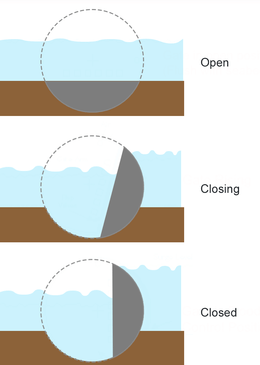
Built across a 520-metre (1,710 ft) wide stretch of the river, the barrier divides the river into four 61-metre (200 ft) and two approximately 30-metre (100 ft) navigable spans. There are also four smaller non-navigable channels between nine concrete piers and two abutments. The flood gates across the openings are circular segments in cross section, and they operate by rotating, raised to allow "underspill" to allow operators to control upstream levels and a complete 180 degree rotation for maintenance. All the gates are hollow and made of steel up to 40 millimetres (1.6 in) thick. The gates are filled with water when submerged and empty as they emerge from the river. The four large central gates are 20.1 metres (66 ft) high and weigh 3,700 tonnes each.[13] Four radial gates by the river banks, also about 30 metres (100 ft) wide, can be lowered. These gate openings, unlike the main six, are non-navigable.
Predictions for operation
A Thames Barrier flood defence closure is triggered when a combination of high tides forecast in the North Sea and high river flows at the tidal limit at Teddington weir indicate that water levels would exceed 4.87 metres (16.0 ft) in central London. Though Teddington marks the Normal Tidal Limit, in periods of very high fluvial flow the tidal influence can be seen as far upstream as East Molesey on the Thames.[14]

Barrier closures and incidents
| Season (Sep–Apr) |
From tidal |
From fluvial |
Total [15] |
|---|---|---|---|
| flooding | |||
| 1982–83 | 1 | 0 | 1 |
| 1983–84 | 0 | 0 | 0 |
| 1984–85 | 0 | 0 | 0 |
| 1985–86 | 0 | 1 | 1 |
| 1986–87 | 1 | 0 | 1 |
| 1987–88 | 0 | 0 | 0 |
| 1988–89 | 1 | 0 | 1 |
| 1989–90 | 1 | 3 | 4 |
| 1990–91 | 2 | 0 | 2 |
| 1991–92 | 0 | 0 | 0 |
| 1992–93 | 4 | 0 | 4 |
| 1993–94 | 3 | 4 | 7 |
| 1994–95 | 2 | 2 | 4 |
| 1995–96 | 4 | 0 | 4 |
| 1996–97 | 1 | 0 | 1 |
| 1997–98 | 1 | 0 | 1 |
| 1998–99 | 2 | 0 | 2 |
| 1999–00 | 3 | 3 | 6 |
| 2000–01 | 16 | 8 | 24 |
| 2001–02 | 3 | 1 | 4 |
| 2002–03 | 8 | 12 | 20 |
| 2003–04 | 1 | 0 | 1 |
| 2004–05 | 4 | 0 | 4 |
| 2005–06 | 3 | 0 | 3 |
| 2006–07 | 8 | 0 | 8 |
| 2007–08 | 6 | 0 | 6 |
| 2008–09 | 1 | 4 | 5 |
| 2009–10 | 2 | 3 | 5 |
| 2010–11 | 0 | 0 | 0 |
| 2011–12 | 0 | 0 | 0 |
| 2012–13 | 0 | 5 | 5 |
| 2013–14 | 9 | 41 | 50 |
| 2014–15 | 1 | 0 | 1 |
| 2015–16 | 1 | 0 | 1 |
| 2016–17 | 2 | 0 | 2 |
| 2017–18 | 3 | 0 | 3 |
| 2018–19 | 2 | 0 | 2 |
| 2019–20 | 8 | 0 | 8 |
| Totals | 105 | 87 | 192 |
During the barrier's entire history up to March 2020, there have been 192 flood defence closures. The barrier was closed twice on 9 November 2007 after a storm surge in the North Sea which was compared to the one in 1953.[16] The main danger of flooding from the surge was on the coast above the Thames Barrier, where evacuations took place, but the winds abated a little and, at the Thames Barrier, the 9 November 2007 storm surge did not completely coincide with high tide.[17]
On 20 August 1989, hours after the Marchioness disaster, the barrier was closed against a spring tide for 16 hours "to assist the diving and salvage operations".[18]
The barrier has survived 15 boat collisions without serious damage.[19]
On 27 October 1997, the barrier was damaged when the dredger MV Sand Kite, operating in thick fog, hit one of the Thames Barrier's piers. As the ship started to sink she dumped her 3,300-tonne load of aggregate, finally sinking by the bow on top of one of the barrier's gates, where she lay for several days. Initially the gate could not be closed as it was covered in a thick layer of gravel. A longer-term problem was the premature loss of paint on the flat side of the gate caused by abrasion. The vessel was refloated in mid-November 1997.[20]
The annual full test closure in 2012 was scheduled for 3 June to coincide with the Thames pageant celebrating Queen Elizabeth II's Diamond Jubilee. Flood risk manager Andy Batchelor said the pageant gave the Environment Agency "a unique opportunity to test its design for a longer period than we would normally be able to", and that the more stable tidal conditions in central London that resulted would help the vessels taking part.[21]
Ownership and operating authority
The barrier was originally commissioned by the Greater London Council under the guidance of Ray Horner. After the 1986 abolition of the GLC it was operated successively by Thames Water Authority and then the National Rivers Authority until April 1996 when it passed to the Environment Agency.
Future
The barrier was originally designed to protect London against a very high flood level (with an estimated return period of one hundred years) up to the year 2030, after which the protection would decrease, while remaining within acceptable limits.[22] At the time of its construction, the barrier was expected to be used 2–3 times per year. By the mid-2000s it was being operated 6–7 times a year.[23] In the 2010s, the barrier was generally closed twice a year but the average is still 6-7 due to the barrier being raised 50 times in 2013–14.
This defence level allowed for long-term changes in sea and land levels as understood at that time (c. 1970). Despite global warming and a consequently greater predicted rate of sea level rise, recent analysis extended the working life of the barrier until around 2060–2070. From 1982 until 19 March 2007, the barrier was raised one hundred times to prevent flooding. It is also raised monthly for testing,[24] with a full test closure over high tide once a year.[21]
Released in 2005, a study by four academics contained a proposal to supersede the Thames Barrier with a more ambitious 16 km (10 mi) long barrier across the Thames Estuary from Sheerness in Kent to Southend in Essex.[25]
In November 2011, a new Thames Barrier, further downstream at Lower Hope between East Tilbury in Essex and Cliffe in Kent, was proposed as part of the Thames Hub integrated infrastructure vision. The barrier would incorporate hydropower turbines to generate renewable energy and include road and rail tunnels, providing connections from Essex to a major new hub airport on the Isle of Grain.[26]
In January 2013, in a letter to The Times, a former member of the Thames Barrier Project Management Team, Dr Richard Bloore, stated that the flood barrier was not designed with increased storminess and sea level rises in mind, and called for a new barrier to be looked into immediately.[27][28] The Environment Agency responded that it does not plan to replace the Thames Barrier before 2070,[29] as the barrier was designed with an allowance for sea level rise of 8 mm (0.31 in) per year until 2030, which has not been realised in the intervening years.[30] The barrier is around halfway through its designed lifespan. The standard of protection it provides will gradually decline over time after 2030, from a 1-in-1000-year event. The Environment Agency are examining the Thames Barrier for its potential design life under climate change, with early indications being that subject to appropriate modification, the Thames Barrier will be capable of providing continued protection to London against rising sea levels until at least 2070.[19][30]
In June 2019 architects Lifschutz Davidson Sandilands and marine engineers Beckett Rankine launched a proposal for a pedestrian and cycle bridge located next to the Thames Barrier; the scheme, called the Thames Barrier Bridge, was promoted as the only location in east London where a low-level opening bridge across the Thames could have relatively moderate opening spans of about 60 m (200 ft).[31][32][33]
In fiction and entertainment
- McCallum Best, a British television series that was produced by STV Productions (Scottish Television) and ran from 1995 to 1998 showed an aerial flyover of the Thames Barrier at night, during the opening and closing credits.
- The 1986 rock music video for "Cross That Bridge" by UK Band The Ward Brothers was filmed both inside and outside Thames Barrier #1.[34]
- In the 1982 Alexei Sayle track "'Ullo John! Gotta New Motor?" the barrier is mentioned in the lyrics, "He works on the Thames barrier – he works on the Thames barrier!"
- The climax of Lois McMaster Bujold's 1989 novel Brothers in Arms takes place in and near a far future version of the Thames Barrier, one which is designed to protect against daily high tides which would otherwise flood London (the novel assumes a far future sea level rise). The barrier in the novel is known colloquially as the "King Canute Memorial".
- In series 5 episode 7 (1992) of firefighting drama London's Burning, Blue Watch are called to the Thames Barrier to rescue a maintenance worker.
- In the tenth episode of Series 5 of Spooks, broadcast in 2006, an environmental group threatens to blow up the Thames Barrier.
- The Thames Barrier appears in the 2006 Doctor Who Christmas special, "The Runaway Bride". The Doctor and his companion Donna Noble emerge from the barrier after defeating the Empress of the Racnoss and her children by flooding her secret underground lair, only to find out that they have accidentally drained the Thames.
- In 2007, in season 10, episode 5 of Top Gear co-host Jeremy Clarkson drives a racing boat through the Thames Barrier while racing James May, Richard Hammond, and The Stig to London City Airport.
- The barrier features as one of the main locations of Flood, a 2007 British disaster film, directed by Tony Mitchell. It features Robert Carlyle, Jessalyn Gilsig, David Suchet and Tom Courtenay. It is based on the 2002 novel of the same name by Richard Doyle.[35]
- The barrier features near the end of the music video for Take That's 2010 hit single, "The Flood".
- The book "Flash Flood" by Chris Ryan is based around a fictional failure of the Thames Barrier and what happens to the city during such a failure.
Gallery
 One of the gates in underspill
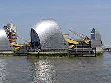 Thames Barrier Pier 6
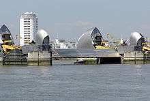 Gate in maintenance
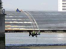 Maintenance close up
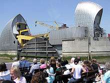 Pier close up
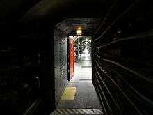 Tunnel underneath the Thames Barrier between piers
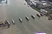 Aerial view of the barrier (lowered)
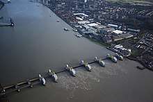 Aerial view of the barrier (raised)
See also
- Barrier Gardens Pier
- Crossings of the River Thames
- Delta Works with the Oosterscheldekering
- Floodgate
- MOSE Project
- Saint Petersburg Dam Flood Prevention Facility Complex
References
- Kendrick, Mary (1988). "The Thames Barrier". Landscape and Urban Planning. 16: 57–68 – via ScienceDirect.
- "Coastal Flooding (Committee's Report) (Hansard, 3 June 1954)". api.parliament.uk. Retrieved 14 April 2020.
- Gilbert, Stuart (Stuart K.) (1984). The Thames barrier. Horner, Ray. London: T. Telford. ISBN 0-7277-0182-7. OCLC 11594001.
- The Thames Barrier: The Background and Basic Engineering Requirements. D Ayres Director of Public Health Engineering, GLC. 1983. Paper presented to a meeting of the Institution of Mechanical Engineers, 8th June 1983
- "Davy McKee (Sheffield) - Graces Guide". www.gracesguide.co.uk. Retrieved 14 April 2020.
- Cleveland Bridge UK projects: Thames Barrier Archived 19 June 2012 at the Wayback Machine
- Environment Agency Archived 17 September 2008 at the Wayback Machine
- "Benring limited: Thames Barrier – subcontracted to Cleveland Bridge UK Ltd". Benring.co.uk. Retrieved 2 May 2013.
- Manufacture and Installation of the Barrier Gates and Operating Machinery - P F Harvey, Davy Cleveland Barrier Consortium - Institution of Mechanical Engineers - Paper presented at a meeting on 8th June 1983.
- "Archive Page Viewer | November 4, 1982 | The Times". ISSN 0140-0460. Retrieved 14 April 2020.
- "Better way to turn the tide". The Guardian. 9 May 1984. p. 2. Retrieved 6 August 2019. – via newspapers.com (subscription required)
- United Kingdom Gross Domestic Product deflator figures follow the Measuring Worth "consistent series" supplied in Thomas, Ryland; Williamson, Samuel H. (2018). "What Was the U.K. GDP Then?". MeasuringWorth. Retrieved 2 February 2020.
- "The Thames Barrier project pack 2010" (PDF). Environment Agency. Archived from the original (PDF) on 12 August 2011. Retrieved 17 October 2011.
- Tom de Castella (11 February 2014). "How does the Thames Barrier stop London flooding?". BBC News. Retrieved 25 February 2014.
- Environment Agency (20 December 2018). "The Thames Barrier". Environment Agency. Retrieved 31 December 2018.
- BBC report, accessed 8 December 2007
- Surge of 9 November 2007 Archived 21 February 2012 at the Wayback Machine The Proudman Oceanographic Laboratory (POL), (a part of the Natural Environment Research Council)
- "Part III". Report of the Chief Inspector of Marine Accidents into the collision between the passenger launch Marchioness and MV Bowbelle with loss of life on the River Thames on 20 August 1989 (PDF) (Report). UK Department of Transport Marine Accident Investigation Branch. 5 June 1990. Retrieved 9 July 2012.
- Hanlon, Michael (18 February 2014). "The Thames Barrier has saved London – but is it time for TB2?". Daily Telegraph. London. Retrieved 3 March 2014.
- Report of the Inspector's Inquiry into the collision of MV Sand Kite with the Thames Flood Barrier on 27 October 1997 (PDF) (Report). UK DETR Marine Accident Investigation Branch. April 1999. Retrieved 24 January 2013.
- "Thames Barrier test closure to be on Jubilee pageant day". BBC News. 6 March 2012. Retrieved 2 January 2013.
- Foundation, Internet Memory. "[ARCHIVED CONTENT] UK Government Web Archive – The National Archives". webarchive.nationalarchives.gov.uk. Archived from the original on 6 June 2009.
- "Predicting and Managing the Effects of Climate Change on World Heritage, A joint report from the World Heritage Centre, its Advisory Bodies, and a broad group of experts to the 30th session of the World Heritage Committee" (Vilnius, 2006) UNESCO, p. 29
- ThamesWeb Archived 23 December 2008 at the Wayback Machine
- Times Online 9 January 2005
- "Thames Hub: An integrated vision for Britain" (PDF). Thames Hub: An integrated vision for Britain. Foster+Partners, Halcrow, Volterra. Archived from the original (PDF) on 10 November 2011. Retrieved 6 November 2011.
- "Letters to the Editor: Thames Barrier". The Times. London. 3 January 2013. Retrieved 13 January 2013.
- "Thames Barrier engineer says second defence needed". BBC News. 5 January 2013. Retrieved 13 January 2013.
- Cole, Margo (10 January 2013). "Environment Agency rejects calls for new Thames Barrier". New Civil Engineer. Retrieved 13 January 2013.
- "Thames Barrier Project Pack 2012" (PDF). Environment Agency. Archived from the original (PDF) on 25 August 2012. Retrieved 2 September 2013.
- New Civil Engineer 3 June 2019
- Architects Journal 3 June 2019
- "Thames Barrier Bridge". Lifschutz Davidson Sandilands, Beckett Rankine. Retrieved 11 June 2019.
- Eduardo Montenegro (18 August 2014). "The Ward Brothers – Cross That Bridge (1986)" – via YouTube.
- Phase 9 Entertainment, "Flood" production details Archived 9 March 2013 at the Wayback Machine. Retrieved 11 January 2011
Further reading
External links
| Wikimedia Commons has media related to Thames Barrier. |
- Thames Barrier page at the Environment Agency
- Animation showing how the Barrier works
- "Time-lapse video showing Thames Barrier operating in flood conditions". Daily Telegraph. 5 January 2014.
- Streetmap of Thames Barrier
- Thames Barrier Information and Learning Centre – on south side of the Thames
- Thames Barrier Park – park by the Barrier on north side of the Thames
- Londons flood defence system
- Map of associated flood barriers
- Risques VS Fictions n°8, filmed interview (subtitled in French) with Steve East, technical support team leader of the real barrier about the depiction of the barrier and scientific accuracy of Flood.
- Sinking Cities: London 55min. PBS
| Districts |
|  |
|---|---|---|
| Attractions |
| |
| Sports |
| |
| Markets |
| |
| Parks and open spaces |
| |
| Constituencies |
| |
| Tube, rail and DLR stations |
| |
| Other topics |
| |
| ||