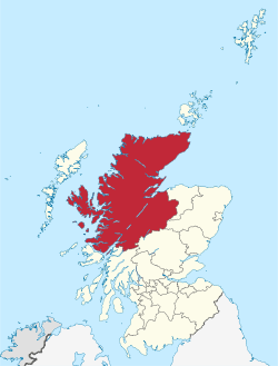
Highland (council area)
Highland (Scottish Gaelic: A' Ghàidhealtachd, pronounced [ˈkɛːəl̪ˠt̪əxk];[lower-alpha 1] Scots: Heilan) is a council area in the Scottish Highlands and is the largest local government area in the United Kingdom. It was the 7th most populous council area in Scotland at the 2011 census. It shares borders with the council areas of Aberdeenshire, Argyll and Bute, Moray and Perth and Kinross. Their councils, and those of Angus and Stirling, also have areas of the Scottish Highlands within their administrative boundaries.
Highland A' Ghàidhealtachd (Scottish Gaelic) Hielan (Scots) | |
|---|---|
 | |
 Coat of arms | |
| Coordinates: 57°30′N 5°00′W | |
| Admin HQ | Inverness |
| Government | |
| • Body | The Highland Council |
| • Control | Ind + LD + Lab (council NOC) |
| • MPs |
|
| • MSPs |
|
| Area | |
| • Total | 9,906 sq mi (25,657 km2) |
| Area rank | Ranked 1st |
| Population (mid-2018 est.) | |
| • Total | 235,540 |
| • Rank | Ranked 7th |
| • Density | 24/sq mi (9.2/km2) |
| ONS code | S12000017 |
| ISO 3166 code | GB-HLD |
The Highland area covers most of the mainland and inner-Hebridean parts of the historic counties of Inverness-shire and Ross and Cromarty, all of Caithness, Nairnshire and Sutherland and small parts of Argyll and Moray. Despite its name, the area does not cover the entire Scottish Highlands.
Name
Unlike the other council areas of Scotland, the name Highland is often not used as a proper noun. The council's website only sometimes refers to the area as being Highland, and other times as being the Highland Council Area or the Highlands.[1][2] Road signs on the boundary of the council area say "Welcome to the Highlands" rather than "Welcome to Highland".
To many people within the area, using the name Highland as a noun sounds wrong. Dingwall in Highland, for example, sounds strange and is not idiomatic usage. To refer specifically to the area covered by the council, people tend to say the Highland Council area or the Highland area or the Highland region. Otherwise, they may also refer to the traditional county names, such as Ross.
Although named after it, the Highland council area does not cover the entire geographic region of the Scottish Highlands themselves. Other parts belong to the council areas of Aberdeenshire, Angus, Argyll and Bute, Moray, North Ayrshire, Perth and Kinross, Stirling or West Dunbartonshire.
History
In 1975, the area was created as a two-tier region, under the Local Government (Scotland) Act 1973, with an elected council for the whole region and, in addition, elected councils for each of eight districts, Badenoch and Strathspey, Caithness, Inverness, Lochaber, Nairn, Ross and Cromarty, Skye and Lochalsh and Sutherland.[3] The act also abolished county and burgh councils.
In 1996, under the Local Government etc. (Scotland) Act 1994, the Highland Regional Council and the district councils were wound up and their functions were transferred to a new Highland Council. The Highland Council adopted the districts as management areas and created area committees to represent them. However, the boundaries of committee areas ceased to be aligned exactly with those of management areas as a result of changes to ward boundaries in 1999. Ward boundaries changed again in 2007, and the management areas and related committees have now been abolished in favour of three new corporate management areas: Caithness, Sutherland and Easter Ross; Inverness, Nairn and Badenoch and Strathspey; and Ross, Skye and Lochaber. The names of these areas are also names of constituencies, but the boundaries are different.
Geography
The Highland Council is based in Inverness, with most previous district council offices retained as outstations.
The council area covers an area of 25,657 square kilometres (9,906 sq mi)[4] – which is 11.4% of the land area of Great Britain, 32.9% of the land area of Scotland and an area 20% larger than Wales.[5] The Highland and Islands division of Police Scotland also includes the Western Isles, Orkney and Shetland (the former area of the Northern Constabulary) and therefore covers an area of 30,659 square kilometres (11,838 sq mi), which is larger than that of the state of Belgium.[6]
Though relatively populous for a Scottish council area, it is also sparsely populated. At 9.0 per km2 in 2012,[7] the population density is less than one seventh of Scotland's as a whole,[7] and comparable with that of Bolivia, Chad and Russia.[8][9] Historically, the area was home to a much higher percentage of Scotland's population. The rural population of the Highlands (both within and outwith the council area) declined in the late 19th century even as Scotland's grew substantially. For example, the population of Skye declined from 23,082 in 1841 to 15,705 in 1891 and a low point of 7,183 in 1971, before growing in more recent decades.
Inverness is by far the largest settlement, with a population of 46,870 in 2012.[10] The urban area around Inverness includes a few outlying villages and has a population of 59,910.[10]
The highest point in the Highland council area is Ben Nevis, the tallest mountain in both Scotland and the United Kingdom as a whole. Its northernmost point is Island of Stroma, in the Pentland Firth. Its southernmost point is on the Morvern peninsula. Highland contains the northernmost and westernmost points of the island of Great Britain, respectively at Dunnet Head and Corrachadh Mòr. Despite the name, not all of Highland is mountainous. The areas east of Inverness, as well as the Black Isle, eastern Sutherland, and all of Caithness are, in fact, low-lying.
Gaelic language
According to the 2011 UK census, there are nearly 12,000 Scottish Gaelic speakers in the Highland area.[11]
Politics
Councillors
The Highland Council represents 22 wards, of which each elects three or four councillors by the single transferable vote system of election, to produce a form of proportional representation in a council of 80 members.
Political composition
The 2017 election resulted in the following composition: [12]
| Party | Councillors | |
| Independent | 27 | |
| SNP | 22 | |
| Conservative | 11 | |
| Liberal Democrat | 10 | |
| Labour | 3 | |
| Scottish Green | 1 |
Members of the Scottish Parliament
For elections to the Scottish Parliament the Highland area is within the Highlands and Islands electoral area, which elects eight first past the post constituency Members of the Scottish Parliament (MSPs) and seven additional member MSPs. Three of the region's constituencies, each electing one MSP, are within the Highland area: Caithness, Sutherland and Ross, Inverness and Nairn and Skye, Lochaber and Badenoch.
The MSPs as at December 2019 are as follows:
| Constituency MSPs | Additional Member MSPs |
|---|---|
|
|
Members of Parliament
In the House of Commons of the Parliament of the United Kingdom the Highland area is represented by Members of Parliament (MPs) elected from three constituencies: Caithness, Sutherland and Easter Ross; Inverness, Nairn, Badenoch and Strathspey; and Ross, Skye and Lochaber. Each constituency elects one MP by the first past the post system of election.
As of the 2019 United Kingdom general election, the members of parliament are:
- Caithness, Sutherland and Easter Ross: Jamie Stone (Liberal Democrats)
- Inverness, Nairn, Badenoch and Strathspey: Drew Hendry (SNP)
- Ross, Skye and Lochaber: Ian Blackford (SNP)
Towns and villages in the Highland Council Area
| Historical Highland population | ||
|---|---|---|
| Year | Pop. | ±% |
| 1801 | 164,294 | — |
| 1811 | 173,235 | +5.4% |
| 1821 | 196,364 | +13.4% |
| 1831 | 211,947 | +7.9% |
| 1841 | 213,969 | +1.0% |
| 1851 | 220,004 | +2.8% |
| 1911 | 226,144 | +2.8% |
| 1921 | 176,396 | −22.0% |
| 1931 | 167,604 | −5.0% |
| 1941 | 166,602 | −0.6% |
| 1951 | 165,600 | −0.6% |
| 1961 | 169,133 | +2.1% |
| 1971 | 172,666 | +2.1% |
| 1981 | 186,916 | +8.3% |
| 1991 | 203,790 | +9.0% |
| 2001 | 208,914 | +2.5% |
| 2011 | 232,132 | +11.1% |
| Source: [13][14] | ||
- Alness (Alanais), Altnaharra (Allt na h-Aire), Applecross (A' Chomraich), Ardersier (Àird nan Saor), Ardgour (Àirde Gobhar), Ardnamurchan (Àird nam murchan), Aviemore (An Aghaidh Mhòr), Avoch (Abhach)
- Back of Keppoch (A' Cheapaich), Ballachulish (Baile a' Chaolais), Beauly (A' Mhanachainn), Bettyhill (Am Blàran Odhar), (the) Black Isle (An t-Eilean Dubh), Boat of Garten (Coit a' Ghartain), Bonar Bridge (Drochaid a' Bhanna), Broadford (An t-Àth Leathann), Brora (Brùra)
- Carrbridge (Drochaid Chàrr), Conon Bridge (Drochaid Sguideil), Cromarty (Cromba), Culloden (Cul Lodan / Cùil-lodair)
- Dalwhinnie (Dail Chuinnidh), Dingwall (Inbhir Pheofharain), Dornie (An Dòrnaidh), Dornoch (Dòrnach), Drumnadrochit (Druim na Droichaid), Dulnain Bridge (Drochaid Thulnain), Durness (Diuranais), Duror (of Appin) (Aphainn Duror)
- Fearn (Manachainn Rois), Fort Augustus (Cill Chuimein), Fortrose (A' Chananaich), Fort William (An Gearasdan)
- Gairloch (Geàrrloch), Glencoe (Gleann Comhann), Glenfinnan (Gleann Fionnan), Golspie (Goillspidh), Grantown-on-Spey (Baile nan Granndach)
- Helmsdale (Bun Ilidh)
- Invergarry (Inbhir Garadh), Invergordon (Inbhir Ghòrdain), Inverie (Inbhir Iodh), Invermoriston (Inbhir Mhoireastain), Inverness (Inbhir Nis)
- John o' Groats (Taigh Iain Ghròt)
- Kingussie (Ceann a' Ghiùbhsaich), Kinlochbervie (Ceann Loch Biorbhaidh), Kinlochleven (Ceann Loch Lìobhann), Knoydart (Cnòideart), Kyle of Lochalsh (Caol Loch Aillse)
- Lochcarron (Loch Carrann), Lochinver (Loch an Inbhir)
- Mallaig (Malaig), Maryburgh (Baile Màiri), Muir of Ord (Am Blàr dubh)
- Nairn (Inbhir Narann), Newtonmore (Baile Ùr an t-Slèibh)
- North Ballachulish (Baile a' Chaolais air Tuath)
- Onich (Omhanaich)
- Plockton (Am Ploc), Portmahomack (Port Mo-Chalmaig), Portree (Port Rìgh)
- Rosemarkie (Ros Maircnidh), Roy Bridge (An Drochaid Ruaraidh)
- Spean Bridge (An Droichaid Spean), Strathpeffer (Srath Pheofhair), Strontian (Sròn an t-Sìthein)
- Tain (Baile Dhubhthaich), Thurso (Inbhir Theòrsa), Tongue (Tunga), Torridon (Toirbheartan)
- Ullapool (Ullapul)
- Wick (Inbhir Ùige)
See also
- Scottish Highlands
- List of places in Highland
- List of places in Argyll and Bute
- List of places in Perth and Kinross
- List of places in Moray
- List of places in the Western Isles
- High Life Highland
Notes
- Gàidhealtachd is used to translate Highland; in other contexts it is used to translate Scottish Highlands and Gaeldom.
References
- "Council Wards". The Highland Council.
- "Our vision for housing in the Highlands". The Highland Council.
- "Highland". BBC. Retrieved 11 October 2015.
- "Standard Area Measurements (2016) for Administrative Areas in the United Kingdom". Office for National Statistics. 1 February 2017. Retrieved 9 February 2017.
- "Breaking up Highland Council into smaller areas debated". BBC News. 14 May 2015.
- "Record police numbers on streets". BBC News. 28 August 2009.
- "Highland profile – key facts and figures". The Highland Council. Retrieved 2 June 2014.
- List of sovereign states and dependent territories by population density
- "Global Health Facts : Demography & Population : Population Density (Population Per Square Kilometer)". The Henry J Kaiser Family Foundation. Retrieved 2 June 2014.
- "Mid-2012 Population Estimates for Settlements and Localities in Scotland". National Records Scotland (NRS). Retrieved 29 October 2015.
- "Gaelic data from Census 2011". The Highland Council. 14 November 2013. Retrieved 11 October 2015.
- Butlin, Heather. "Highland Council". www.highland.gov.uk.
- "Highland District through time - Population Statistics - Total Population". www.visionofbritain.org.uk.
- "Vision of Britain - 1911 Census: County Report - Table 1". www.visionofbritain.org.uk. no-break space character in
|title=at position 25 (help)
External links
| Wikimedia Commons has media related to Highland (council area). |
- Highland (council area) at Curlie
- The Highland Council
- Comhairle na Gaidhealtachd (in Scottish Gaelic)
- The Highland council area in the Gazetteer for Scotland website
- Scottish Highlands and Islands Film Commission
Local government areas of Scotland, in use 1973 to 1996 | ||
|---|---|---|
| Borders |
|  |
| Central Region |
| |
| Dumfries and Galloway |
| |
| Fife |
| |
| Grampian |
| |
| Highland |
| |
| Lothian |
| |
| Strathclyde |
| |
| Tayside |
| |
| Island areas1 |
| |
1 The island areas were unitary authorities, combining the powers of a region and a district. | ||