M6 motorway
The M6 motorway runs from junction 19 of the M1 at the Catthorpe Interchange, near Rugby, Coventry via Birmingham then heads north, passing Stoke-on-Trent, Liverpool, Manchester, Preston, Lancaster, Carlisle and terminating at the Gretna junction (J45). Here, just short of the Scottish border it becomes the A74(M) which continues to Glasgow as the M74. Its busiest sections are J4-10a at Birmingham and J16-19 in Cheshire as this forms the main route from the East/West Midlands and London to Manchester and Liverpool, These sections are now Smart Motorway.
| ||||
|---|---|---|---|---|
_map.svg.png) | ||||
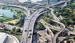 Gravelly Hill Interchange, best known as Spaghetti Junction | ||||
| Route information | ||||
| Part of | ||||
| Maintained by Highways England | ||||
| Length | 232.2 mi (373.7 km) | |||
| Existed | 1958–present | |||
| History | Opened: 1958 Completed: 2008 | |||
| Major junctions | ||||
| South end | Catthorpe 52.400442°N 1.175215°W | |||
M1 motorway J2 → M69 motorway J3a → M6 Toll J4 → M42 motorway J4a → M42 motorway J6 → A38(M) motorway J8 → M5 motorway J10a → M54 motorway J11a → M6 Toll J20 → M56 motorway J21a → M62 motorway J26 → M58 motorway J29 → M65 motorway J30 → M61 motorway J32 → M55 motorway J35 → A601(M) motorway J45 → A74(M) motorway | ||||
| North end | Gretna 54.996672°N 3.055336°W | |||
| Location | ||||
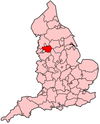
| Counties | Leicestershire, Warwickshire, West Midlands, Staffordshire, Cheshire, Merseyside, Greater Manchester, Lancashire, Cumbria | |||
| Primary destinations | Rugby Coventry Birmingham Walsall Wolverhampton Cannock Stafford Stoke-on-Trent Newcastle-under-Lyme Crewe Warrington Wigan Preston Lancaster Kendal Penrith Carlisle | |||
| Road network | ||||
| ||||

As of 2020, combining the length of the M11 from Wanstead in London before becoming the A14, then continuing as the M6, having it become the A74(M) and M74 until the junction with the M8 in Glasgow, the entire road network combined forms the longest continuous motorway in the United Kingdom and one of the busiest. It incorporated the Preston By-pass, the first length of motorway opened in the UK and forms part of a motorway "Backbone of Britain", running north−south between London and Glasgow via the industrial North of England. It is also part of the east−west route between the Midlands and the east-coast ports. The section from the M1 to the M6 Toll split near Birmingham forms part of the unsigned E-road E 24 and the section from the M6 Toll and the M42 forms part of E 05.
Route
The M6 motorway runs from junction 19 of the M1 and from the beginning of the A14 in Catthorpe near Rugby in central England, passes between Coventry, Bedworth and Nuneaton, through Birmingham, Walsall and Stafford and near the smaller cities of Wolverhampton and Stoke-on-Trent.[1] The motorway has major junctions with the M55 at Junction 32, north of Preston ending just before Blackpool, the M65 at Junction 29, south of Preston, towards Blackburn and then Burnley, the M56 and M62 at Warrington, giving access to Chester, Manchester and Liverpool.[2] The M6 then heads north past Wigan, Preston and Lancaster.[3] After the latter two cities it passes through Cumbria with some parts very close to the edge of the Lake District with a short stretch within the national park boundaries and then passes Carlisle on its way to Gretna,[4] before the motorway becomes the A74(M) a few hundred metres short of the Scottish border.[5][6]
History
Planning and construction
The first section of the motorway and the first motorway in the country was the Preston By-pass. It was built by Tarmac Construction and opened by the Prime Minister Harold Macmillan on 5 December 1958.[7] In January 1959 the Preston by-pass was closed because of rapid surface deterioration over a stretch of 100 yards (91 m) "due to water freezing and then thawing". Motorists were diverted to the old road while the UK road research laboratory at Harmondsworth pondered the importance of surface water drainage.[8]
Later, other sections of the motorway were constructed, and finally it was all linked together, giving an uninterrupted motorway length of 230 miles (370 km).[9][10][11]

The second phase of construction was completed in 1960, forming the Lancaster by-pass. Some 100 miles (160 km) south, the Stafford by-pass was completed in 1962.[12][13] By 1965, the remaining sections of motorway Stafford–Preston and Preston–Lancaster had been completed. 1968 saw the completion of the Walsall to Stafford link as well as the Penrith by-pass some 150 miles (240 km) north in Cumberland. In 1970, the Lancaster–Penrith link was completed, along with a short section of motorway by-passing the south of Walsall. The most northerly section of the motorway also opened in 1970, running to the designated terminus north of Carlisle. By 1971,[12] the full route was completed between the junction with the M1 motorway at Rugby and the A38 road several miles north-east of Birmingham city centre, including Bromford Viaduct between Castle Bromwich (J5) and Gravelly Hill (J6), which at 3½ miles is the longest viaduct in Great Britain.[14][15]
Junction 6 in Birmingham is widely known as Spaghetti Junction because of its complexity and round and curvy-like design. On the elevated ground between Shap and Tebay, the north and south-bound carriages split apart.[16] At this point a local road (to Scout Green) runs between the two carriageways without a link to the motorway.[17]
The section of the M6 that runs over Shap Fell in Cumbria is 1,036 ft (316 m) above sea level, one of the highest points on any motorway in the UK (junction 22 of the M62 on Saddleworth Moor is higher). The motorway engineers here chose to follow the route of the Lancaster and Carlisle Railway engineered by Joseph Locke (now part of the West Coast Main Line) where the motorway runs in a split-level cutting above the railway in the descent from Shap Fell through the Lune Gorge into southern Cumbria.[18]
The northbound entry slip road at Lancaster (junction 34) was unusually short, presenting problems for traffic joining the motorway. The M6 crosses the River Lune at this point and unless the bridge had been made wider, there was no space to build a longer slip road. This junction was upgraded from an earlier emergency-vehicles-only access point, which explains the substandard design.[19] The construction of the Heysham to M6 Link Road (The Bay Gateway) has completely re-modelled this junction with a wide additional bridge over the River Lune and other works repositioning slip roads with new acceleration lanes to modern standards.
The route was originally intended to replace the old A6, which it does along the northern section starting with the Preston Bypass. However, a much closer approximation to the overall actual route of the M6 (heading north from its southern terminus) is provided by following the A45, A34, A50, A49, then the A6.[20] South of Preston, the A6 route is instead supplemented by the M61 as far as Manchester, with the M60 acting as a bypass around the city. South of Manchester, there is no true motorway replacement for the old road. The M1 acts as a bypass for long-distance traffic in the south, from the Kegworth junction near Nottingham, to Luton and St. Albans near London; but, it is not an alternative for local traffic as the routes diverge by more than 15 miles while passing through Northamptonshire. Across the Pennines, the old road remains the main local through-route, and long-distance fast traffic between Derby and Manchester must instead take either the A50 and M6, or M1 and M62.[21]
Operational
In July 1972 the UK Minister for Transport Industries announced that 86 miles (138 km) of UK motorway particularly prone to fog would benefit from lighting in a project which "should be" completed by 1973.[22] Sections to be illuminated included the M6 between junctions 10 and 11, and between junctions 20 and 27.[22]
In March 2006, after 15 years of debate,[23] the government authorised the construction of a 6-mile (9.7 km) extension of the M6 from its then northern terminus near Carlisle to the Anglo-Scottish border at Gretna (the so-called "Cumberland Gap"), where it links into the existing A74(M).[24] The road opened on 5 December 2008, the 50th anniversary of the M6 Preston By-pass.[25] The project, which was a mixture of new road and upgrade of the existing A74, crosses the West Coast Main Line and had an estimated costs of £174 million. It completed an uninterrupted motorway from just south of Dunblane (via the M9, the recently opened M80 section near Cumbernauld and the M73) in the north to Exeter (via the M5) and to London (via both the M42/M40 and the M1) in the south.[26]
The M6 Toll, Britain's first toll motorway, which bypasses the West Midlands conurbation to the east and north of Birmingham and Walsall and was built to alleviate congestion through the West Midlands, and opened in December 2003. Before the opening of the toll motorway, this section of the M6 carried 180,000 vehicles per day at its busiest point near Wolverhampton (between the junctions with the M54 and M5 motorways), compared with a design capacity of only 72,000 vehicles. Usage, at about 50,000 vehicles, was lower than expected and traffic levels on the M6 were only slightly reduced as a result. The high toll prices, which were set by the operating company and over which the UK government has no influence until 2054, were blamed for the low usage.[27] Much traffic continues to use the M6 or the continued on the M1 and took the A50 or A52.[28] As of July 2012 the road between Junctions 3A and 11A now carries 120,000 motor vehicles every day.[29]
A proposed extension to the M6 Toll known as the 'M6 Expressway', which would have continued from the M6 Toll as far as Knutsford, at which point much of the existing M6 traffic leaves the M6 for Manchester, was abandoned in 2006 due to excessive costs, anticipated construction problems[30] and disappointing levels of use of the M6 Toll.
In October 2007, following a successful trial on the M42 in the West Midlands, the UK government announced that two stretches of the M6 would be upgraded to allow the hard shoulder to be used as a normal running lane during busy conditions under a scheme called active traffic management.[31] The two stretches, between junctions 4 and 5 and between junctions 10a and 8, are two of the busiest sections on the entire motorway.[32] It was then proposed that the system could be extended onto other stretches of the M6 while the government undertook a feasibility study to determine other likely locations for this technology to be used.[33] The stretch between junctions 4 and 5 was completed during December 2009[34] while the stretch between junctions 10a and 8 was completed during March 2011.[35] This was then followed by a stretch between junctions 5 and 8 which started construction in April 2012 and was completed in October 2014.[36]
Current developments
Managed motorway J13 to 15 and J16 to 19
After plans of the government to improve reliability and capacity between Junctions 11 by Cannock and Junction 19 near Knutsford, it favoured a new motorway in 2004, 'The Expressway' following a roughly parallel course to the existing M6.[37][38] In July 2006, the government announced its decision to abandon the Expressway proposal, and favoured widening accompanied by demand-management measures,[30] and launched a study to consider options for providing additional capacity.[39] After the stretch between junction 10a and 13 was upgraded to a managed motorway in February 2016,[40] it was then proposed to introduce a managed motorway between junction 13 and 19,[41] later divided into two separate stretches, between junctions 16 and 19 and junctions 13 and 15.[42] The stretch between junctions 16 and 19 started construction in December 2015[43] and was completed in March 2019[44] while construction on the stretch between junctions 13 and 15 commenced in March 2018.[45]
Work started in 2020 to reconstruct the bridges above the M6 at junction 10 due to frequent congestion at peak times.
Junctions
Data from driver location signs are used to provide distance and carriageway identifier information. Where a junction spans several hundred metres (yards) and the start and end distances are known, both distances are shown.[46][47]
| M6 motorway junctions | |||||
| mile | km | Northbound exits (A carriageway) | Junction | Southbound exits (B carriageway) | Coordinates |
| Motorway continues as A74(M) towards Scotland | Start of motorway | 54.996672°N 3.055336°W | |||
| 313.2 | 504.3 | Gretna B7076, Longtown A6071 | J45 |
No access (on-slip only) | 54.992979°N 3.048234°W |
| River Esk | 54.974768°N 3.009213°W | ||||
| 309.6 309.2 |
498.2 497.5 |
Todhills Rest Area | Services | Todhills Rest Area | 54.951585°N 2.979612°W |
| 307.6 307.3 |
495.1 494.6 |
Carlisle (North), Galashiels A7 | J44 |
Carlisle A7, Workington A689 | 54.930138°N 2.946332°W |
| River Eden | 54.909346°N 2.895290°W | ||||
| 303.8 303.5 |
488.9 488.4 |
Carlisle, Hexham, Newcastle A69 | J43 | Carlisle, Hexham, Newcastle A69 | 54.895293°N 2.886851°W |
| 301.1 300.7 |
484.6 484.0 |
Carlisle (South) A6 | J42 | Carlisle A6 | 54.85759°N 2.878375°W |
| Southwaite services | Services | Southwaite services | 54.799077°N 2.871079°W | ||
| 288.7 288.4 |
464.6 464.1 |
Wigton B5305 | J41 | Wigton B5305 | 54.69343°N 2.791729°W |
| 285.5 285.2 |
459.5 459.0 |
Penrith, Workington, Brough A66 | J40 | Penrith, Keswick, Brough A66 | 54.653056°N 2.760186°W |
| 274.4 274.0 |
441.6 441.0 |
Shap (A6) | J39 | Shap, Kendal (A6) | 54.508252°N 2.649765°W |
| Tebay services | Services | Tebay services | 54.451304°N 2.608008°W | ||
| River Lune | 54.44115°N 2.59518°W | ||||
| 268.9 268.5 |
432.7 432.1 |
Brough A685, Appleby B6260 | J38 | Kendal, Brough A685 | 54.436805°N 2.596893°W |
| 260.3 260.0 |
418.9 418.4 |
Kendal, Sedbergh A684 | J37 | Kendal, Sedbergh A684 | 54.330965°N 2.622857°W |
| No access | Services | Killington Lake services | 54.315046°N 2.639122°W | ||
| 252.7 252.3 |
406.7 406.0 |
Barrow, Kendal A590 (A591), Kirkby Lonsdale A65 | J36 | Skipton, Kirkby Lonsdale A65, Barrow A590 | 54.236365°N 2.716541°W |
| Burton-in-Kendal services | Services | No access | 54.178185°N 2.733879°W | ||
| Entering Cumbria | Entering Lancashire | 54.17005°N 2.73748°W | |||
| 245.1 244.6 |
394.4 393.6 |
Carnforth, Morecambe A601(M) (A6) | J35 | Carnforth, Morecambe A601(M) (A6) | 54.128700°N 2.749758°W |
| 240.8 240.6 |
387.6 387.2 |
Kirkby Lonsdale, Heysham, Morecambe, Heysham |
J34 | Lancaster, Morecambe, Heysham A683 | 54.071578°N 2.771087°W |
| 234.6 234.3 |
377.6 377.1 |
Lancaster (South) A6 | J33 | Garstang, Fleetwood A6 | 53.982516°N 2.780743°W |
| Lancaster (Forton) services | Services | Lancaster (Forton) services | 53.962095°N 2.760229°W | ||
| River Wyre | 53.95391°N 2.75135°W | ||||
| 221.5 221.0 |
356.5 355.7 |
Blackpool, Fleetwood M55 Preston (N) (A6) |
J32 | Blackpool, Preston (N) (A6) M55 | 53.806759°N 2.697787°W |
| 219.5 219.3 |
353.2 352.9 |
Preston (E), Longridge B6242 | J31A | No access (on-slip only) | 53.788940°N 2.658262°W |
| River Ribble | J31 | Preston, Clitheroe A59 | 53.764949°N 2.635903°W | ||
| Preston (C), Blackburn (N), Clitheroe A59 | River Ribble | ||||
| 215.4 214.9 |
346.6 345.9 |
No access (on-slip only) | J30 | Manchester, Bolton M61, Leeds (M62), Blackburn (M65) | 53.734320°N 2.647705°W |
| 213.9 213.5 |
344.3 343.6 |
Burnley, Blackburn, Preston (S) M65 | J29 | Burnley, Blackburn M65 | 53.716190°N 2.660751°W |
| 212.3 211.9 |
341.6 341.0 |
Leyland B5256 (A49) | J28 | Leyland B5256 | 53.695893°N 2.677574°W |
| Charnock Richard services | Services | Charnock Richard services | 53.631534°N 2.690835°W | ||
| 204.8 | 329.6 | Entering Lancashire | J27 | Wigan, Parbold A5209 | 53.589728°N 2.694440°W |
| 204.4 | 329.0 | Parbold, Standish, Chorley A5209 | Entering Greater Manchester | ||
| 200.8 200.5 |
323.1 322.6 |
Skelmersdale, Liverpool, Southport M58 | J26 | Skelmersdale, Liverpool, Southport M58 | 53.534110°N 2.698045°W |
| 198.0 197.8 |
318.7 318.3 |
Wigan A49 | J25 | No access (on-slip only) | 53.501806°N 2.659678°W |
| 196.9 196.5 |
316.9 316.3 |
No access (on-slip only) | J24 | St Helens, Ashton A58 | 53.486718°N 2.652898°W |
| Entering Greater Manchester | Entering Merseyside | 53.4802°N 2.64398°W | |||
| 195.6 195.2 |
314.8 314.1 |
St Helens, Liverpool, Southport A580 | J23 | Manchester, Liverpool, Newton A580 | 53.471292°N 2.633629°W |
| 192.4 | 309.6 | Entering Merseyside | J22 | Warrington (North) A49 | 53.440116°N 2.584105°W |
| 192.1 | 309.1 | Newton A49, Leigh A579 | Entering Cheshire | ||
| 191.0 190.5 |
307.4 306.5 |
Leeds, Bolton, Manchester (N) M62 | J21A | Manchester, Bolton, Leeds M62 | 53.425926°N 2.555909°W |
| Liverpool, Warrington (N), Southport (M57) M62 | Liverpool M62 | ||||
| 188.3 188.0 |
303.0 302.5 |
Warrington (Ctr & East), Irlam A57 | J21 | Warrington (Central), Irlam A57 | 53.397814°N 2.509947°W |
| Thelwall Viaduct | 53.389753°N 2.505784°W | ||||
| 185.6 | 298.7 | NORTH WALES, Chester, Runcorn M56 Warrington (South), Lymm A50 Lymm Truck Stop |
J20 Services |
Macclesfield, Warrington (S) A50, Lymm B5158 Lymm Truck Stop |
53.360413°N 2.509089°W |
| 185.3 184.5 |
298.2 296.9 |
NORTH WALES, Chester, Runcorn, Manchester (S & |
53.358466°N 2.507973°W | ||
| End of variable speed limit |
J19 | Start of variable speed limit |
53.311596°N 2.417636°W | ||
| 180.3 179.9 |
290.2 289.5 |
Manchester, Manchester |
Northwich, Macclesfield, Knutsford A556 | ||
| Knutsford services | Services[Note 2] | Knutsford services | 53.300826°N 2.401586°W | ||
| 172.2 171.9 |
277.2 276.7 |
Chester, Northwich, Middlewich A54 | J18 | Chester, Northwich, Middlewich A54 | 53.200377°N 2.387509°W |
| 168.9 168.3 |
271.3 270.8 |
Congleton, Sandbach A534 | J17 | Congleton, Sandbach A534 | 53.153230°N 2.346697°W |
| Sandbach services | Services | Sandbach services | 53.139048°N 2.336526°W | ||
| 162.6 | 261.7 | Entering Cheshire | J16 | Newcastle-under-Lyme, Stoke-on-Trent (North), Crewe, Nantwich A500 | 53.068632°N 2.333565°W |
| Start of variable speed limit |
End of variable speed limit | ||||
| 162.3 | 261.2 | Nantwich, Crewe A500 | Entering Staffordshire | ||
| Keele services | Services | Keele services | 52.993555°N 2.289362°W | ||
| 153.1 152.9 |
246.4 246.1 |
Stoke-on-Trent, Newcastle-under-Lyme A500 | J15 | Stoke-on-Trent, Stone A500, Derby (A50) | 52.975573°N 2.226319°W |
| Stafford services (northbound) | Services | No access | 52.883919°N 2.168555°W | ||
| No access | Stafford services (southbound) | 52.873948°N 2.164907°W | |||
| 142.0 141.8 |
228.6 228.2 |
Stone, Stafford (N) A34 | J14 | Stafford (N) A34 | 52.826520°N 2.145596°W |
| End of variable speed limit |
J13 | Start of variable speed limit |
52.763567°N 2.107873°W | ||
| 136.8 136.5 |
220.1 219.6 |
Stafford (S & C) A449 | Stafford (S) A449 | ||
| 131.6 131.2 |
211.8 211.1 |
Telford (M54) A5 | J12 | NORTH WALES, Telford (M54), Wolverhampton, Cannock A5 | 52.689026°N 2.103453°W |
| No access (on-slip only) | J11A (TOTSO SB) |
The SOUTH M6 Toll | 52.669538°N 2.074270°W | ||
| 128.7 128.4 |
207.2 206.7 |
(M6 Toll), Cannock A460 | J11 | Wolverhampton, Cannock A460 | 52.658424°N 2.06440°W |
| Hilton Park services | Services | Hilton Park services | 52.643402°N 2.056503°W | ||
| 127.0 126.7 |
204.4 203.9 |
NORTH & MID WALES, Telford, Wolverhampton, Shrewsbury (A5) M54 | J10A | No access (on-slip only) | 52.630172°N 2.048950°W |
| Entering West Midlands | 52.61874°N 2.03209°W | ||||
| Entering Staffordshire | 52.61693°N 2.03038°W | ||||
| 123.3 122.9 |
198.4 197.8 |
Walsall, Wolverhampton (C & E) A454 | J10 | Wolverhampton (C & E), Walsall A454 | 52.584877°N 2.014275°W |
| 121.7 121.5 |
195.8 195.6 |
Wednesbury A461 | J9 | Wednesbury A461 | 52.566543°N 2.003202°W |
| 119.9 | 193.0 | The SOUTH WEST, Birmingham (W & S), West Bromwich M5 | J8 |
The SOUTH WEST, Birmingham (W & S), West Bromwich M5 | 52.557125°N 1.976681°W |
| 118.4 118.1 |
190.6 190.1 |
Birmingham (N), Walsall A34 | J7 |
Birmingham (N) A34 | 52.553081°N 1.934023°W |
| 114.2 113.9 |
183.8 183.3 |
Birmingham (C) A38(M) Birmingham (NE) A38 |
J6 |
Birmingham (NE), Lichfield A38 Birmingham (E & C) A38(M) |
52.510083°N 1.863792°W |
| Bromford Viaduct | 52.506°N 1.829°W | ||||
| 110.9 110.8 |
178.5 178.3 |
Birmingham (E), Sutton Coldfield A452 | J5 |
No access (on-slip only) | 52.509274°N 1.789076°W |
| Entering Warwickshire | 52.51302°N 1.75356°W | ||||
| 108.8 108.6 |
175.1 174.8 |
No access (on-slip only) | J4A | The NORTH EAST (M1), The NORTH WEST (M6 Toll), Tamworth M42(N) The SOUTH WEST (M5), London (S & W) (M40), Birmingham (S), Birmingham International |
52.509966°N 1.747062°W |
| Entering West Midlands | 52.47857°N 1.71495°W | ||||
| 106.0 | 170.6 | Start of variable speed limit |
J4 | Coventry (S & W), Birmingham (E), N.E.C., Birmingham International |
52.476808°N 1.707237°W |
| 105.7 | 170.1 | Coleshill A446 The SOUTH WEST (M5), Birmingham (S), Solihull, N.E.C., Birmingham |
End of variable speed limit | ||
| The NORTH WEST M6 Toll, Tamworth M42(N) | J3A (TOTSO NB) |
No access (on-slip only) | 52.473880°N 1.671681°W | ||
| Corley services | Services | Corley services | 52.471488°N 1.546326°W | ||
| 96.9 96.4 |
155.9 155.2 |
Coventry (North), Nuneaton, Bedworth A444 | J3 | Coventry (N), Nuneaton A444, Bedworth B4113 | 52.463004°N 1.493776°W |
| Entering Warwickshire | Entering West Midlands | 52.45798°N 1.48271°W | |||
| Entering West Midlands | Entering Warwickshire | 52.43995°N 1.43995°W | |||
| 93.7 93.3 |
150.8 150.1 |
Coventry (E) A46, Leicester M69 | J2 | (M1(N)), Leicester M69, Coventry (E) A46 | 52.437870°N 1.429832°W |
| 85.6 85.2 |
137.8 137.1 |
Rugby A426 | J1 | Rugby, Lutterworth A426 | 52.408087°N 1.245725°W |
| Entering Warwickshire | Entering Leicestershire | 52.40604°N 1.2096°W | |||
| 85.2 | 137.1 | Start of motorway |
M1 J19 |
The SOUTH, London, Northampton M1 | 52.400442°N 1.175215°W |
| The NORTH, Leicester M1(N) | End of motorway Road continues as A14 towards Kettering | ||||
- Notes
Legislation
Each motorway in England requires that a legal document called a Statutory Instrument is published, detailing the route of the road, before it can be built. The dates given on these Statutory Instruments relate to when the document was published, and not when the road was built. Provided below is an incomplete list of the Statutory Instruments relating to the route of the M6.
- Statutory Instrument 1987 No. 252: County Council of West Midlands (M6 Motorway Junction 10) (Connecting Road) Scheme 1985 Confirmation Instrument 1987[48]
- Statutory Instrument 1987 No. 2254: M6 Motorway (Catthorpe Interchange) Connecting Roads Scheme 1987[49]
- Statutory Instrument 1990 No. 2659: M6 Motorway: Widening between Junctions 20 and 21A (Thelwall Viaduct) and Connecting Roads Scheme 1990[50]
- Statutory Instrument 1991 No. 1873: M6 Motorway (Widening and Improvements Between Junctions 30 and 32) and Connecting Roads Scheme 1991[51]
- Statutory Instrument 1993 No. 1370: Lancashire County Council (Proposed Connecting Roads to M6 Motorway at Haighton) Special Roads Scheme 1992 Confirmation Instrument 1993[52]
- Statutory Instrument 1997 No. 1292: M6 Birmingham to Carlisle Motorway (At Haighton) Connecting Roads Scheme 1997[53]
- Statutory Instrument 1997 No. 1293: M6 Birmingham To Carlisle Motorway (at Haighton) Special Roads Scheme 1997 Transfer Order 1997[54]
- Statutory Instrument 1998 No. 125: The M6 Motorway (Saredon and Packington Diversions) Scheme 1998[55]
See also
- List of motorways in the United Kingdom
- Category:M6 motorway service stations
References
- Frommer's Short (22 December 2011). "4". The Borders and Galloway Regions, Scotland: Frommer's ShortCuts. 1. I (I ed.). London: John Wiley & Sons. pp. 56–. ISBN 978-1-118-27111-7.
- Highways Agency, ed. (2004). "1". M6 Route Management Strategy: Warrington to the Scottish Borders : Final Strategy Summary Brochure, January 2004. 1. 1 (I ed.). Scotland: Highways Agency. p. 54.
- Lesley Anne Rose; Michael Macaroon; Vivienne Crow (6 January 2012). "36". Frommer's Scotland. I. I (I ed.). London: John Wiley & Sons. pp. 424–. ISBN 978-1-119-99276-9.
- Baldwin, Peter; Porter (M.S.), John; Baldwin, Robert (2004). "72". In Thomas Telford (ed.). The Motorway Achievement. I. I (One ed.). London: Thomas Telford. pp. 836–. ISBN 978-0-7277-3196-8. Retrieved 9 July 2012.
- Highways Agency, ed. (2004). "1". M6 Route Management Strategy: Warrington to the Scottish Borders : Final Strategy Summary Brochure, January 2004. 1. 1 (I ed.). Scotland: Highways Agency. p. 73.
- Frommer's Short (22 December 2011). "3". The Borders and Galloway Regions, Scotland: Frommer's ShortCuts. I. I (I ed.). Scotland: John Wiley & Sons. pp. 56–. ISBN 978-1-118-27111-7. Retrieved 9 July 2012.
- "Preston Bypass Opening (Booklet)" (PDF). Archived from the original (PDF) on 29 February 2008. Retrieved 20 January 2008.
- "The Preston By-pass-Enquiry Needed". Practical Motorist and Motor Cyclist. Vol. 5 no. 57. March 1959. p. 803.
- Surveyor. The St. Bride's press. 1978. p. 21.
- British Information Services; Great Britain. Central Office of Information (1 January 1970). "I". Survey of British and Commonwealth affairs. One. I (I ed.). England, United Kingdom: Published for British Information Services by Her Majesty's Stationery Office. Retrieved 9 July 2012.
- Great Britain. Central Office of Information. Reference Division; British Information Services (1979). Inland transport in Britain. H.M.S.O. ISBN 978-0-11-700989-9. Retrieved 9 July 2012.
- Institution of Highway Engineers (1981). The Highway engineer. Institution of Highway Engineers. p. 23. Retrieved 9 July 2012.
- "III". Surveyor. 1. XII (XII ed.). London: The St. Bride's press. 1978. p. 35.
- "''ciht.org.uk''". Ciht.org.uk (Self-published). Archived from the original on 7 February 2012. Retrieved 31 December 2011.
- John Porter (M.S.) (2002). The Motorway Achievement: Frontiers of Knowledge and Practice. Thomas Telford. pp. 539–. ISBN 978-0-7277-3197-5.
- T. G. Carpenter (27 January 2011). Construction in the Landscape: A Handbook for Civil Engineering to Conserve Global Land Resources. Routledge. pp. 143–. ISBN 978-1-84407-923-0. Retrieved 9 July 2012.
- "2". The Spectator. 245. F.C. Westley. 1980. Retrieved 9 July 2012.
- Great Britain. Ministry of Housing and Local Government (1965). The Municipal Journal. 73. Municipal Journal.
- Great Britain: Parliament: House of Commons: Transport Committee; Parliament Transport Committee Great Britain House of Commons (2 August 2005). Road Pricing: The Next Steps; Seventh Report of Session 2004–05. The Stationery Office. pp. 46–. ISBN 978-0-215-02566-1.
- Peter Baldwin; John Porter (M.S.); Robert Baldwin (2004). The Motorway Achievement. Thomas Telford. pp. 469–. ISBN 978-0-7277-3196-8.
- "M6". The Motorway Archive. Midland Links Motorways. Self-published. Archived from the original on 7 February 2012. Retrieved 9 July 2012.
- "News: Motorway lighting". Autocar. Vol. 137 no. 3978. 13 July 1972. p. 19.
- "M6 Carlisle — Gretna". CBRD. Self-published. Archived from the original on 27 October 2007. Retrieved 20 January 2008.
- "M6 Carlisle to Guards Mill Extension". Highways Agency. Archived from the original on 10 August 2012. Retrieved 3 May 2014.
- "M6 North Extension, United Kingdom". Road Traffic Technology. Retrieved 20 January 2008.
- Royal Town Planning Institute (2006). "I". Planning: for the natural and built environment. I. I (1 ed.). London: Planning Publications. p. 14.
- "one year after study" (PDF). Highways Agency. 11 August 2005. Archived from the original (PDF) on 15 November 2009. Retrieved 24 January 2008.
- Highways & road construction international. 41. 1973.
- Great Britain. Parliament. House of Commons (2012). Parliamentary debates: Official report. H.M. Stationery Off.
- "Decision on M6 Upgrade Announced". News Distribution Service for the Government and Public Sector. Archived from the original on 4 May 2008. Retrieved 3 May 2014.
- "Hard-shoulder scheme to go nationwide". The Independent. 27 October 2007. Archived from the original on 27 October 2007. Retrieved 25 January 2007.
- Baldwin, Peter; John, Porter (M.S.); Baldwin, Robert; Thomas Telford (2004). "XIV". In Thomas Telford (ed.). The Motorway Achievement. I. I (I ed.). London: Thomas Telford. p. 693. ISBN 978-0-7277-3196-8.
- Baldwin, Peter; John, Porter (M.S.); Baldwin, Robert; Thomas Telford (2004). "XV". In Thomas Telford (ed.). The Motorway Achievement. I. I (I ed.). London: Thomas Telford. pp. 694–. ISBN 978-0-7277-3196-8.
- "Highways Agency: Transport Minister opens England's second Hard Shoulder Running Scheme". MyNewsDesk. MyNewsDesk. Retrieved 5 January 2018.
- "Hard shoulders opens on busy M6 by Birmingham". BBC News. BBC News. Retrieved 5 January 2018.
- "M6 Birmingham Box ATM Phase 3". Roads.org. Roads.org. Retrieved 26 March 2019.
- "Encouraging better use of roads and the M6". Department for Transport. Archived from the original on 11 August 2007. Retrieved 20 January 2008.
- Great Britain: Parliament: House of Commons: Welsh Affairs Committee (22 December 2010). The Severn crossings toll: third report of session 2010–11, report, together with formal minutes and written evidence. The Stationery Office. pp. 58–. ISBN 978-0-215-55570-0. Retrieved 9 July 2012.
- "M6 Jct 11A – 19 (Increasing Capacity) Study". Highways Agency. Archived from the original on 10 August 2012. Retrieved 3 May 2014.
- "M6 J10A-13 Smart Motorway". Roads.org. Roads.org. Retrieved 21 May 2019.
- "M6 Junctions 13–19 Managed Motorway".
- "Big six share £1.5bn smart motorway contracts". The Construction Index. The Construction Index. Retrieved 5 January 2018.
- "M6 junctions 16-19: smart motorway". Highways England. Highways England. Retrieved 5 January 2018.
- "M6 smart motorway upgrade between Crewe and Knutsford opens". BBC News. BBC News. Retrieved 26 March 2019.
- "M6 junction 13 to junction 15 smart motorway". Highways England. Highways England. Retrieved 27 July 2018.
- Driver Location Signs, M6 J4-18(map) Highway Authority 2009. Retrieved 9 July 2012.
- Driver Location Signs, Highway Agency Area 10 (map) – Highway Authority, 2009. Retrieved 9 July 2012.
- "S.I. 1987/252". Office of Public Sector Information. Retrieved 9 July 2012.
- "S.I. 1987/2254". Office of Public Sector Information. Retrieved 9 July 2012.
- "S.I. 1990/2659". Office of Public Sector Information. Retrieved 9 July 2012.
- "S.I. 1991/1873". Office of Public Sector Information. Retrieved 9 July 2012.
- "S.I. 1993/1370". Office of Public Sector Information. Retrieved 9 July 2012.
- "S.I. 1997/1292". Office of Public Sector Information. Retrieved 9 July 2012.
- "S.I. 1997/1293". Office of Public Sector Information. Retrieved 9 July 2012.
- "S.I. 1998/125". Office of Public Sector Information. Retrieved 9 July 2012.
Further reading
- Jackson, Mike (2004). The M6 Sights Guide. Severnpix. ISBN 978-0954540210.
External links
- CBRD
- Lancashire Historic Highways – a page supplied by Lancashire County Council detailing the history of the M6 in North West England, and the construction of Preston Bypass, the UK's first motorway.
- Route 6
- The Motorway Archive
Motorways in the United Kingdom | ||||||
|---|---|---|---|---|---|---|
| Great Britain | .svg.png) | |||||
| Northern Ireland |
| |||||
| Former |
| |||||
| Unbuilt |
| |||||
| Junctions |
| |||||
| Related articles |
| |||||
| ||||||
| City centre streets |
|
|---|---|
| City centre squares |
|
| Suburban streets |
|
| A roads |
|
| Motorways |
|
| Defunct |
|
| |
Transport in Greater Manchester | |||||||
|---|---|---|---|---|---|---|---|
| |||||||
| Air |
|  | |||||
| Bus |
| ||||||
| Road | |||||||
| Tram |
| ||||||
| Cycle |
| ||||||
| Rail |
| ||||||
| TIF bid |
| ||||||
| |||||||