Henderson, Kentucky
Henderson is a home rule-class city[2] along the Ohio River and is the county seat of Henderson County in western Kentucky in the United States. The population was 28,757 at the 2010 U.S. census.[3] It is part of the Evansville Metropolitan Area, locally known as the "Tri-State Area". It is considered the southernmost suburb of Evansville, Indiana.
Henderson, Kentucky | |
|---|---|
City | |
 North Main Street | |
 Location of Henderson in Henderson County, Kentucky. | |
| Coordinates: 37°50′8″N 87°34′51″W | |
| Country | United States |
| State | Kentucky |
| County | Henderson |
| Established | 1797 |
| Incorporated | 1840 |
| Named for | land speculator Richard Henderson |
| Government | |
| • Mayor | Steve Austin |
| Area | |
| • Total | 17.6 sq mi (45.6 km2) |
| • Land | 15.3 sq mi (39.6 km2) |
| • Water | 2.3 sq mi (5.9 km2) 13.01% |
| Elevation | 407 ft (124 m) |
| Population (2010) | |
| • Total | 28,757 |
| • Estimate (2018)[1] | 28,432 |
| • Density | 1,879/sq mi (725.6/km2) |
| Time zone | UTC−6 (CST) |
| • Summer (DST) | UTC−5 (CDT) |
| ZIP Codes | 42420, 42419 |
| Area code(s) | 270 & 364 |
| FIPS code | 21-35866 |
| GNIS feature ID | 0494023 |
| Website | www |
Notable residents have included the ornithologist, naturalist, and painter John James Audubon and blues legend W. C. Handy.
History
18th century
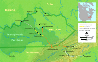
Henderson has its roots in a small, block-wide strip of land high above the Ohio River, the site of the present-day Audubon Mill Park directly south of the city's riverfront boat dock. A village on this site was called "Red Banks" because of the reddish clay soil of the bluffs overlooking the Ohio River.[4] The future city was named after Richard Henderson, an eighteenth-century pioneer and land speculator, by his associates Samuel Hopkins and Thomas Allin. Henderson County also shares this namesake. On March 17, 1775, North Carolina judge Richard Henderson and his Transylvania Company had met with 1,200 Cherokee in a council at Sycamore Shoals (present-day Elizabethton, Tennessee) to purchase over 17,000,000 acres (69,000 km2) of land between the Ohio, Cumberland, and Kentucky rivers in present-day Kentucky and Tennessee to resell it to white settlers. Known as the Transylvania Purchase, the sale was voided by the Virginia General Assembly, since the territory (and the sole right to purchase land from Indians within its bounds) was part of Virginia's royal charter. However, the commonwealth granted Henderson and his company an area of 200,000 acres (810 km2) to develop. It was located at the confluence of the Green and Ohio rivers. Henderson hired Daniel Boone to survey the country and select favorable sites, but Henderson died before the town was developed.
By the early 1790s, Red Banks had a tavern and several European-American families co-existing with the local Cherokee. On November 16, 1792, resident Robert Simpson wrote to Alexander D. Orr in Lexington, requesting help to appoint a magistrate for Red Banks to deal with some of its 30 families he felt were of dubious (criminal) character. During this period, the Red Banks settlement had gained notoriety as a frontier haven for westward-moving outlaws and their families. One such family was that of Squire Samuel Mason. By that time, excluding the Cherokee, the free male inhabitants of Red Bank totaled 62. Later, in 1797, Captain Young of Mercer County, Kentucky and the "Exterminators", a group of regulators under his leadership swiftly and violently drove out the remaining outlaw element in Red Banks.[5]
Samuel Hopkins and the surveyor Thomas Allin visited Red Banks in 1797 and laid out plans for the future town of Henderson. It was formally established by the Kentucky legislature the same year.[6] A distinguishing characteristic of the new town plan was unusually wide streets, reportedly to prevent a fire in one block from easily spreading to another. Even with diagonal parking spaces outlined on downtown streets today, the streets are wide enough to include two-way traffic and space left over for delivery trucks to park in the center of the streets without interfering. By October 29, 1799, a census for the city of Henderson showed a population of 183. The county had 423 residents, 207 slaves, and 412 horses.
19th century
A post office was established in the town in 1801;[7] the city was formally incorporated on January 21, 1840.[6]
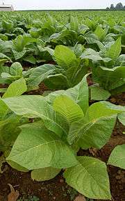
By mid-century, Henderson County had become a major producer of tobacco, much of which was exported to Great Britain. The area was reported to be the largest dark tobacco producer in the world; large tobacco warehouses and stemmeries dotted the downtown Henderson area. Postcards from the era show long lines of horse- and mule-drawn wagons piled high with tobacco, waiting their turn to unload for shipment downriver. Some tobacco processors accumulated considerable fortunes.
20th century
Shortly before World War I, Henderson was said to have more millionaires per capita than any other city in the world. Great Britain, however, imposed a high tariff on imported tobacco after the war, wrecking the county and city's export market. Tobacco warehouses and plants closed, and the community's economic fortunes reversed. The last tobacco facility, the Soaper Tobacco Warehouse on Pennell Street, closed in 1984.
Henderson continued as a regional center into the 20th century. Businesses were concentrated in the downtown area. In the early 20th century, recognizable neighborhoods (unincorporated places) within the city and the outlying edges of town included Audubon, Weaverton, and Audubon Heights. Segments of Audubon and Weaverton were sometimes referred to as the "East End", which held the second-largest business area after downtown Henderson.
Natural disasters
Henderson had unusual weather patterns in the late 1800s and early 1900s. The "great sleet" of 1901 fell for three weeks in February. "Horses had to have special shoes to keep their footing on local roads."[8]
In 1908 the Henderson area had high temperatures and a drought, which markedly reduced the flow of the Ohio River. The Henderson Daily Gleaner reported that "boys were playing baseball every day in the middle of the old riverbed." All businesses were challenged and forced to close. A Henderson reporter wrote, "[I]t is almost hazardous for even small gasoline boats to run".[9]
On June 20, 1914, Henderson was hit by a "baby cyclone". Jack Hudgions, local historian and newsman, wrote that "hail as large as partridge eggs" fell for ten minutes and that powerful winds uprooted giant trees "and twisted limbs from shade trees in the city." In the northern part of Henderson, several buildings were blown down and wheat stocks were scattered. The storm lasted for more than 30 minutes, laying crops low throughout the county. Telephone lines were damaged and windows broken in the city and county by the hailstones. 26 days later, the city was hit by a tornado that left two dead and much of the city in ruins.[8]
In 1937, 21 inches (530 mm) of precipitation fell in 18 days over the Ohio River watershed, resulting in the Ohio River flood of 1937 and extensive damage. Henderson, on its bluff, was spared much of the damage that Pittsburgh, Cincinnati, Louisville, Evansville, Paducah and other river cities suffered. Leigh Harris, the publisher of the Henderson Gleaner and Evening Journal newspapers, wrote, "Henderson is on the river but never in it!" Its favorable location helped the city attract new industries.[10]
21st century
A workplace shooting occurred at an Atlantis Plastics factory in Henderson on June 25, 2008. The gunman, 25-year-old Wesley Neal Higdon, shot and killed five people and critically injured a sixth person before taking his own life.[11] The shooting is the worst in the history of Henderson County in terms of casualties, surpassing triple homicides occurring in 1799 and 1955.[12]
Geography
Henderson is located in north-central Henderson County at 37°50′8″N 87°34′51″W (37.835587, -87.580713).[13] It is 10 miles (16 km) south of Evansville, Indiana, and 30 miles (48 km) west of Owensboro, Kentucky. According to the United States Census Bureau, Henderson has a total area of 17.6 square miles (45.6 km2), of which 15.3 square miles (39.6 km2) are land and 2.3 square miles (5.9 km2), or 13.01%, are water.[3] As the state line tends to follow the Indiana side of the river, most of the Ohio River going past Henderson is within the city limits.
Because the Indiana-Kentucky border is defined as the low-water mark on the north bank of the Ohio River as of 1792, and because the river changed course as a result of the New Madrid earthquake of 1812, a small portion of Henderson County (approximately 4 miles (6 km) long and 1 mile (1.6 km) wide), lies north of the current course of the river in what would appear to be part of Indiana. Both the Bi-State Vietnam Gold Star Bridges and the Ellis Park Race Course horse racing track are located entirely within Kentucky. The racetrack uses Indiana's 812 area code despite officially being located in Kentucky.
Transportation
The Henderson Area Rapid Transit (HART) was created in 1957 as a publicly owned mass transit system, of which all citizens who live in the city of Henderson are part owners.


ZIP codes and area codes
The ZIP codes used in the city of Henderson are 42419 and 42420, and it uses the telephone area codes 270 and 364. Because the two area codes cover the same geographic region, 10-digit dialing (i.e., including the area code when dialing, even for local calls) has been required since February 2014. The exceptions are the Ellis Park Race Course racing track (as mentioned above), the Kentucky DOT truck scale, and the Trocadero Plaza Sinclair station, all located on US Highway 41, and the Marina Plaza on adjacent Waterworks Road, which all use Indiana's 812 area code despite being located in Henderson County.
Climate
The climate in this area is characterized by hot, humid summers and generally mild to cool winters. According to the Köppen Climate Classification system, Henderson has a humid subtropical climate, abbreviated "Cfa" on climate maps.[14]
Demographics
| Historical population | |||
|---|---|---|---|
| Census | Pop. | %± | |
| 1800 | 205 | — | |
| 1810 | 159 | −22.4% | |
| 1830 | 484 | — | |
| 1850 | 1,775 | — | |
| 1870 | 4,171 | — | |
| 1880 | 5,365 | 28.6% | |
| 1890 | 8,835 | 64.7% | |
| 1900 | 10,272 | 16.3% | |
| 1910 | 11,452 | 11.5% | |
| 1920 | 12,169 | 6.3% | |
| 1930 | 11,668 | −4.1% | |
| 1940 | 13,160 | 12.8% | |
| 1950 | 16,837 | 27.9% | |
| 1960 | 16,892 | 0.3% | |
| 1970 | 22,976 | 36.0% | |
| 1980 | 24,834 | 8.1% | |
| 1990 | 25,945 | 4.5% | |
| 2000 | 27,373 | 5.5% | |
| 2010 | 28,757 | 5.1% | |
| Est. 2018 | 28,432 | [1] | −1.1% |
| U.S. Decennial Census[15] | |||
As of the census[16] of 2000, there were 27,373 people, 11,693 households, and 7,389 families residing in the city. The population density was 1,829.0 people per square mile (706.0/km²). There were 12,652 housing units at an average density of 845.4 per square mile (326.3/km²). The racial makeup of the city was 84.1% White, 11.8% Black or African American, 0.18% Native American, 0.7% Asian, 0.01% Pacific Islander, 0.58% from other races, and 1.04% from two or more races. Hispanics or Latinos of any race were 1.27% of the population.
There were 11,693 households out of which 29.8% had children under the age of 18 living with them, 45.5% were married couples living together, 14.1% had a female householder with no husband present, and 36.8% were non-families. 32.1% of all households were made up of individuals and 12.9% had someone living alone who was 65 years of age or older. The average household size was 2.27 and the average family size was 2.86.
The age distribution was 23.5% under the age of 18, 9.2% from 18 to 24, 29.5% from 25 to 44, 22.5% from 45 to 64, and 15.3% who were 65 years of age or older. The median age was 37 years. For every 100 females, there were 89.3 males. For every 100 females age 18 and over, there were 85.3 males.
The median income for a household in the city was $30,427, and the median income for a family was $39,887. Males had a median income of $32,131 versus $22,225 for females. The per capita income for the city was $17,925. About 13.2% of families and 16.5% of the population were below the poverty line, including 24.6% of those under age 18 and 11.3% of those age 65 or over.
Economy
The county has numerous industries, including aluminum production, automotive and appliance parts, plastic injection molding, tool and die making, food processing and processing of recycled materials. In June 2008, of the 20,205 jobs in Henderson, almost 12% were government jobs. It also ranks as one of Kentucky's top three corn and soybean producers. Henderson County is also one of the state's leading coal producers, with over 2.8 million tons produced in 2004.[17]
Education
The Henderson County school system includes eight elementary schools: A.B. Chandler, Spottsville, East Heights, Bend Gate, South Heights, Jefferson, Cairo, and Niagara; two middle schools, North Middle and South Middle; and one high school, Henderson County High School. The Thelma B. Johnson Early Learning Center serves pre-schoolers, and there is an alternative school for those suspended from the other schools in the district, Central Academy.[18] There is one parochial school, Holy Name of Jesus Catholic School.[19] and also a school for students with mental and/or physical deficiencies, Riverview School.
Henderson is home to one postsecondary institution, Henderson Community College, as well as a satellite campus of Murray State University.[20] In addition, students are served by Oakland City University Evansville Center, the University of Evansville, and the University of Southern Indiana in Evansville.
Henderson has a lending library, the Henderson County Public Library.[21]
Culture
Annual festivals
Each year Henderson hosts a variety of events and festivals. The Henderson Breakfast Lions Club holds the Tri-Fest, a street festival that raises funds for non-profit organizations, in mid-April each year. There is also the free Handy Blues & Barbecue Festival in mid-June and the free Bluegrass in the Park Folklife Festival in August. Annual barbecues have been a Henderson tradition dating as far back as the one started on Sunday, July 18, 1926 in Atkinson Park by the Henderson Freight Station employees. Notable foods were lamb, burgoo, etc.[22]
Bluegrass in the Park Folklife Festival is one of the largest free Bluegrass festivals in the country. It is Henderson's oldest on-going music festival and marked its 25th continuous year in 2010. Past performers have included Bill Monroe, Emmylou Harris, Alison Krauss and Union Station, Ricky Skaggs, John Hartford, Glen Campbell, and other notable Bluegrass artists. The Folklife aspect of the festival is a celebration of local lifestyles and culture with displays on recreational folklife (traditional games), functional folklife (quilting, tatting, chair-caning, basket-making, fly-tying), oral traditions (storytelling), folk music, food traditions (curing country hams, making burgoo, the craft of barbecue), and foreign cultures that have integrated with local traditions, among other things.[23][24]
The Green River Arts & Crafts Festival is a large event that has been held for more than 30 years on a weekend in early October at John James Audubon State Park and organized by the Green River Area Development District.[25]
Points of interest
- John James Audubon State Park—Ornithologist, naturalist, and painter John James Audubon spent several years in Henderson in the 1810s. He had a store with his partner Ferdinand Rozier before deciding to work at art full-time. He is honored in the downtown with nine cast-bronze sculptures based on paintings from his Birds of America series, at the John James Audubon State Park and Museum. It houses the world's largest collection of Audubon memorabilia and one of the most extensive collections of his work. The park offers an Audubon sculpture walking tour set in a landscape where visitors may also see wildlife.[25]
- River Front— The city's downtown and river front has a simple design, particularly the Audubon Mill Park. Along with the parks, the river front's play area showcases a popular water park fountain. The water park has two areas; one larger area contains forty-five jets varying in height from a few feet to a towering fifteen feet, and the second play area has smaller jets approximately two feet in height. This one offers endless amusement for children. Trails and benches lead along the Ohio river for walkers and bikers. Visitors may enjoy looking at the CSX Bridge crossing the river to Indiana. Two docks extend from the downtown river bank to serve the numerous pleasure-boaters that recreate on the Ohio River.
- Green River State Forest—About five miles (8 km) northeast of Henderson is 1,106 acres (4.48 km2) of the Green River State Park. This park is open for the public for recreational uses such as hunting, fishing, or hiking. More than half of the park is situated at the bottoms of Henderson's bluff toward the Ohio river, with 65–70 acres (260,000–280,000 m2) of swampland. The land has been used by humans since prehistoric times. In the mid-16th century, the Spanish DeSoto Expedition camped here. His chroniclers wrote of hostilities between the Spanish and the Native Americans. The Green River State Forest and Henderson's north side have sites that are considered part of Desoto's Trail.
- The Sloughs—Nearly 10,000 acres (40 km2) of the city is a wetland area. The land has several bald cypress sloughs or swamp. In the winter, more than 60,000 geese and ducks use the wetlands during seasonal migrations. Hunters, fishermen, hikers, campers, or nature lovers enjoy the area for its many kinds of wildlife, including turtles, coyotes, and many bald eagles.
- Metzger's Tavern, the oldest continuously operating tavern in the state of Kentucky, founded in 1887 and named to the 2010 Huffington Post's top 25 dive bars in the United States.[26][27]
Media
Henderson is served by one local daily newspaper, The Gleaner, as well as the metro edition of the Evansville Courier & Press. Both are owned by the E.W. Scripps Company.
Henderson is part of the Evansville media market, the 101st-largest television market[28] and 161st-largest radio market[29] in the United States. WSON (860-AM) is the only locally owned radio station broadcasting from the city. Stations from Owensboro and Madisonville are also available. Some can hear stations from Fort Campbell, Clarksville and Paducah as well.
WEHT, Evansville's ABC affiliate, has its studios and transmitting tower located in Henderson, though it is licensed to Evansville. Until December 2011, it was the only area TV station headquartered in Henderson, but when then-WTVW owner Nexstar Broadcasting purchased WEHT, it spun off the former to its business partner, Mission Broadcasting, and entered into a shared services agreement through which WEHT and WTVW are co-managed.
Notable people
Art and culture
- Young Ewing Allison, writer, editor and publisher
- John J. Becker, composer
- Ingram Crockett, poet and journalist
- Teddy Darby, blues musician
- Misti Dawn, pornographic actress, model
- Ewing Galloway, journalist and county prosecutor[30]
- Joey Goebel, author
- Gregg Hale, film producer, Blair Witch Project
- W.C. Handy, African-American blues legend, (spent about a decade in Henderson)
- Rosa Henderson, American jazz and blues singer
- Kristen Johnson, former Miss Kentucky USA
- Grandpa Jones, Louis Marshall "Grandpa" Jones, banjo player, comedian, born in Henderson County
Armed services
- Adam Johnson, Confederate brigadier general in the Civil War
- Rear Admiral Husband E. Kimmel, commander of the U.S. Pacific Fleet during the Japanese attack on Pearl Harbor
- Command Sergeant Major Gary L. Littrell, Medal of Honor recipient for his service during the Vietnam War
- Corporal Luther Skaggs, Jr., Medal of Honor recipient for his service with the Marine Corps in the Pacific Theater of WWII
Business
- Amos G. Rhodes, Atlanta furniture magnate and namesake of Rhodes Hall
- Don Ball, philanthropist, businessman, and founder of Ball Homes.
Government and politics
- John Young Brown, U.S. congressman, governor of Kentucky
- Albert Benjamin "Happy" Chandler, U.S. senator, governor of Kentucky, commissioner of Major League Baseball
- James Franklin Clay, U.S. congressman
- John Lloyd Dorsey, Jr., U.S. congressman
- Samuel Mason, early settler, justice of the peace, soldier, and river pirate
- Carl D. Melton, Kentucky state representative and judge
- Lazarus W. Powell, former governor of Kentucky
- Ann Rutledge, first love of Abraham Lincoln; was born just outside Henderson
- Augustus O. Stanley, Governor of Kentucky
Science and research
- John James Audubon, ornithologist (spent several years in Henderson in the 1810s)
- Darrell A. Posey, anthropologist, ethnobiologist
See also
- Bi-State Vietnam Gold Star Bridges
- Cities and towns along the Ohio River
- John James Audubon State Park and Museum
- Southern Cherokee Nation of Kentucky
- Metzger's Tavern
References
- "Population and Housing Unit Estimates". Retrieved June 4, 2019.
- "Summary and Reference Guide to House Bill 331 City Classification Reform" (PDF). Kentucky League of Cities. Retrieved December 30, 2014.
- "Geographic Identifiers: 2010 Demographic Profile Data (G001): Henderson city, Kentucky". American Factfinder. U.S. Census Bureau. Retrieved June 30, 2017.
- Rennick, Robert M (2013). Kentucky Place Names. University Press of Kentucky. ISBN 978-0-8131-4401-6.
- Starling, Edmund Lyne (1887). "History of Henderson County, Kentucky". Henderson, KY. pp. 31–34.
- Commonwealth of Kentucky. Office of the Secretary of State. Land Office. "Henderson, Kentucky". Accessed 29 Jul 2013.
- Rennick, Robert M. (1987). Kentucky Place Names. University Press of Kentucky. p. 137. ISBN 0813126312. Retrieved 28 Apr 2013.
- "Cyclone", Henderson History
- "Dry Ohio", Henderson, Kentucky History
- "Flood", Henderson History
- Lenz, Ryan (2008-06-25). "6 dead in Henderson, Ky., plastics plant shooting". Associated Press. Archived from the original on June 28, 2008.
- Smith, Beth (2008-06-26). "Rampage at Atlantis Plastics ends with six dead". Henderson Gleaner.
- "US Gazetteer files: 2010, 2000, and 1990". United States Census Bureau. 2011-02-12. Retrieved 2011-04-23.
- Climate Summary for Henderson, Kentucky
- "Census of Population and Housing". Census.gov. Retrieved June 4, 2015.
- "U.S. Census website". United States Census Bureau. Retrieved 2008-01-31.
- "Kentucky Geological Survey". University of Kentucky. Archived from the original on June 4, 2008. Retrieved 2007-02-23.
- "Henderson County Schools Website". Retrieved 2014-08-12.
- "Holy Name of Jesus Catholic School". Retrieved 2007-02-23.
- "Murray State University Henderson Regional Campus". Murray State University. Archived from the original on 2010-07-10. Retrieved 2007-02-23.
- "Kentucky Public Library Directory". Kentucky Department for Libraries and Archives. Archived from the original on 11 January 2019. Retrieved 5 June 2019.
- "Depot Henderson Barbecue Henderson County". Hendersonkyhistory.com. Retrieved 2012-05-15.
- "Handy Blues & Barbecure Festival Website". Retrieved 2007-02-23.
- "Bluegrass in the Park Website". Archived from the original on 2011-07-08. Retrieved 2007-02-23.
- "John James Audubon State Park". Kentucky Department of Parks. Archived from the original on 2006-12-05. Retrieved 2007-02-10.
- "Find. Eat. Drink.'s Great Dive Bars Across America". Huffington Post. 2011-09-13. Retrieved November 13, 2017.
- "Historical Metzger's Tavern wins Best award". Henderson Gleaner. Retrieved November 13, 2017.
- "Nielsen | What People Watch | What People Buy". Nielsenmedia.com. Retrieved 2012-05-15.
- Market Ranks and Schedule (151-200) Archived October 13, 2008, at the Wayback Machine
- "Ewing Galloway Dies of Injury". Kentucky New Era. 29 June 1953. Retrieved 4 June 2013.
Further reading
- Trafton, Spalding (October 1930). "Silk Culture in Henderson County, Kentucky". Filson Club History Quarterly. 4 (4).
External links
| Wikivoyage has a travel guide for Henderson (Kentucky). |
| Wikimedia Commons has media related to Henderson, Kentucky. |
Evansville, IN–KY Metropolitan Statistical Area | ||
|---|---|---|
| Central City | 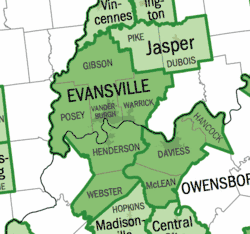 | |
| Municipalities with population over 5,000 in 2010 |
| |
| Municipalities with population 1,000-5,000 in 2010 |
| |
| Indiana Counties |
| |
| Kentucky Counties |
| |
Municipalities and communities of Henderson County, Kentucky, United States | ||
|---|---|---|
| Cities |
|  Map of Kentucky highlighting Henderson County |
| CDPs |
| |
| Other communities |
| |
| Ghost town |
| |
| Footnotes | ‡This populated place also has portions in an adjacent county or counties | |
Frankfort (capital) | ||
| Topics |  Seal of Kentucky | |
| Society |
| |
| Regions |
| |
| 25 largest cities |
| |
| Metropolitan areas |
| |
| Counties |
| |
| Authority control |
|
|---|