Malda City
Malda or English Bazar is a metropolitan city in the Indian state of West Bengal. It is the sixth largest city in West Bengal.[4] It is the district headquarters of Malda district. It consists of two municipalities - English Bazar Municipality and Old Malda Municipality, under English Bazar Metropolitan Area. This was an Undeveloped City which was enlarging since 1925-1930. The city is growing rapidly with its population inching towards half million.
Malda English Bazar | |
|---|---|
Metropolitan City / Urban Agglomeration | |
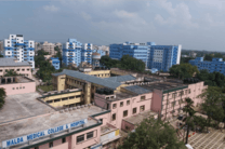
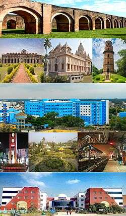 Malda City Skyline view | |
| Nickname(s): Mango City | |
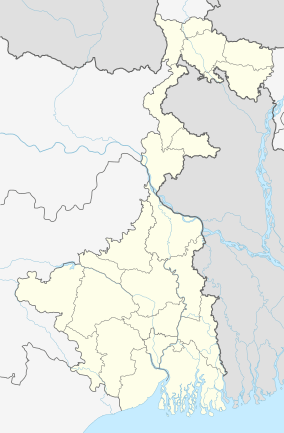 Malda Location in West Bengal, India 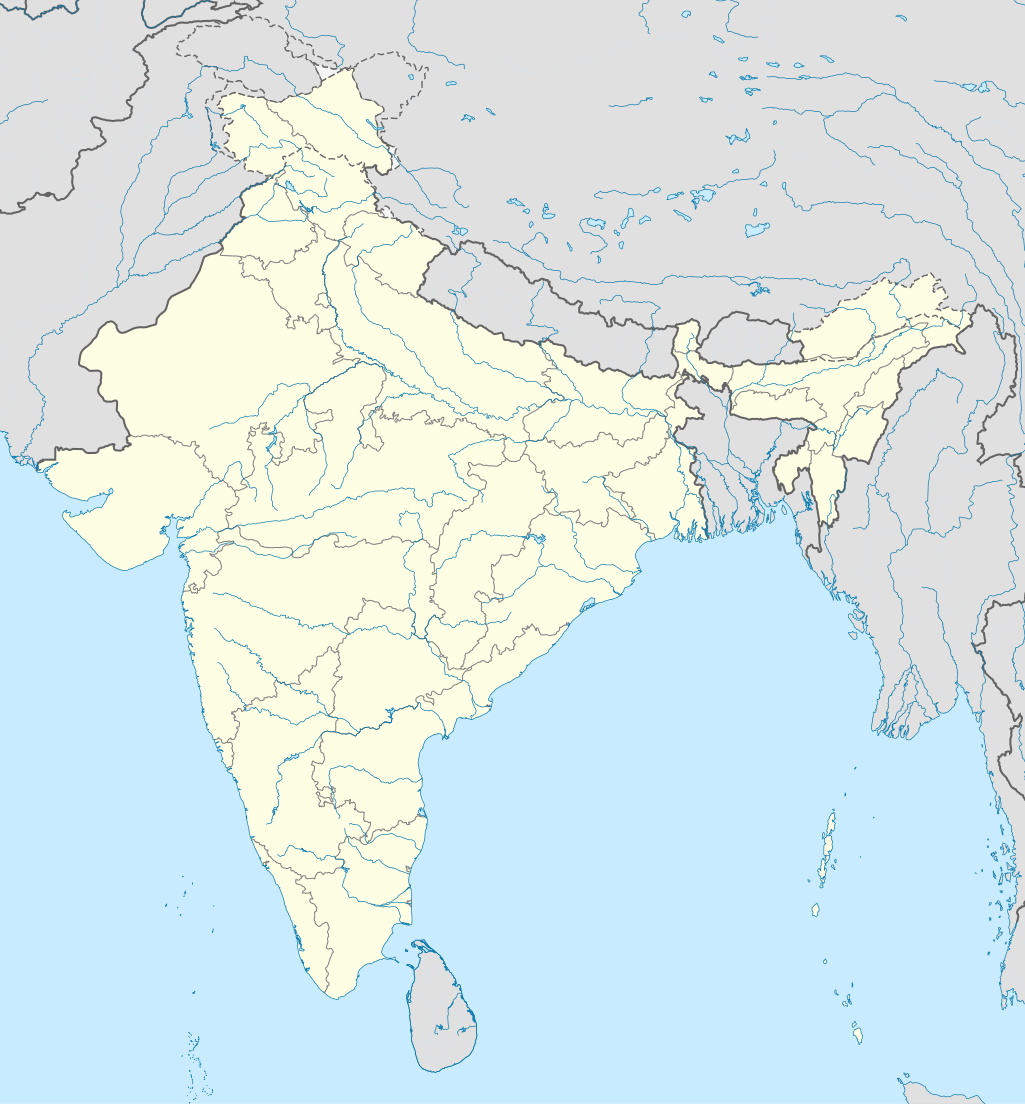 Malda Malda (India)  Malda Malda (Asia) | |
| Coordinates: 25.0119°N 88.1433°E | |
| Country | India |
| State | West Bengal |
| District | Malda |
| Division | Malda |
| Railway Station | Malda Town railway station |
| Total Wards | 49 |
| Government | |
| • Type | Municipality |
| • Body | English Bazar Municipality Old Malda Municipality |
| • Chairman | Nihar Ranjan Ghosh |
| • Chairman | Kartick Ghosh |
| Area 13.25 km²(Town) | |
| • Metropolitan City / Urban Agglomeration | 81 km2 (31 sq mi) |
| Elevation | 17 m (56 ft) |
| Population (2011)[1] | |
| • Metropolitan City / Urban Agglomeration | 324,237 |
| • Rank | 6th in West Bengal |
| • Density | 4,000/km2 (10,000/sq mi) |
| • Metro | 216,083 |
| Demonym(s) | Maldabasi |
| Languages | |
| • Official | Bengali[2][3] |
| • Additional official | English[2] |
| Time zone | UTC+5:30 (IST) |
| PIN | 732101, 732102, 732103, 732141, 732142, 732128 |
| Telephone code | 91-3512-2xxxxx |
| Vehicle registration | WB-65/WB-66 |
| Lok Sabha constituency | Maldaha Dakshin, Maldaha Uttar |
| Vidhan Sabha constituency | English Bazar, Malda |
| River | Mahananda River |
| Website | www |
Geography
Malda is located at 25.0119°N 88.1433°E Malda district, West Bengal.[5] It has an average elevation of 17 metres (56 feet). It is on the western bank of the river Mahananda.As in much of Bengal, the weather is usually extremely humid and tropical. Temperatures can reach as high as 46 °C during the day in May and June and fall as low as 4 °C overnight in December and January.
In Malda, the average annual temperature is 25.4 °C | 77.7 °F. Precipitation here is about 1349 mm | 53.1 inch per year.[6]MALDA AVERAGE TEMPERATURE graph here.The driest month is December. There is 1 mm | 0.0 inch of precipitation in December. The greatest amount of precipitation occurs in July, with an average of 319 mm | 12.6 inch.
MALDA WEATHER BY MONTH
Civic administration
There are two municipalities in Malda. The English Bazar Municipality and the Old Malda Municipality.
The municipality of English Bazar Municipality is divided into 29 wards. The Trinamool Congress with 15 councillors holds power (as of 2015).
The municipality of Old Malda Municipality is divided into 20 wards.[7]
Transport
Road
![]()
Rail
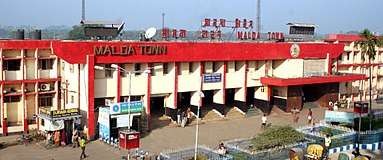
There are four railway stations which serves the metropolitan city. These are Malda Town Railway Station which serves the English Bazar area. Second one is Old Malda Railway Station which serves the Old Malda area. The third one is Malda Court Railway Station which serves the Mangalbari and Naldubi area and Gour Malda railway station which serves the Mohhadipur and Gauḍa (city) area.

Air
Malda Airport (IATA: LDA, ICAO: VEMH) was closed in 1972 due to the Bangladesh War. Before that there were direct daily flights from Malda to Kolkata, Delhi, and Guwahati. In 2014 direct helicopter services were started between Malda and Kolkata, the capital of West Bengal, by the government of West Bengal. As of 2017 the airport is under construction and the flight service will start very soon.
Demographics
As of the 2011 census, Malda metropolitan city had a total population of 324,237.[8]
As of the 2011 census, English Bazar municipality had a population of 216,083.[1] The municipality had a sex ratio of 877 females per 1,000 males and 14.9% of the population were under six years old.[1] Effective literacy was 84.69%; male literacy was 85.44% and female literacy was 83.86%.[1]
As of 2001 India census,[9] Old Malda Municipality had a population of 62,944. Males constitute 52% of the population and females 48%. Old Malda has an average literacy rate of 61%, higher than the national average of 59.5%: male literacy is 67%, and female literacy is 54%. In Old Malda, 15% of the population is under 6 years of age. Most of the people are Hindu. Some Muslim, Shikh, Christian people live here.
Education
Colleges and universities
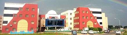
Several colleges and universities are in and around English Bazar. The largest is the University of Gour Banga, established in 2008. Almost all the 28 colleges in Malda, Uttar Dinajpur and Dakshin Dinajpur districts, except for Raiganj University College, are affiliated with it.
Other notable institutions include Malda College, established on 23 July 1944, the oldest higher educational institution in the city; The Gour Mahavidyalaya, only one college in the Malda district and nearby districts which is offers Mass Communication and Journalism course with 3 years B.A (Honours) and Malda Women's College, the only women's college in the city. English Bazar has three engineering colleges:Ghani Khan Choudhury Institute of Engineering & Technology established in 2010 is a Centrally Funded Technical Institute under Ministry of Human Resource Development Government of India; IMPS College of Engineering and Technology, established in 2003; and Malda Polytechnic, one of the oldest and best polytechnic colleges in West Bengal
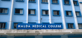
Malda Medical College and Hospital is the only medical college.

Universities
- University of Gour Banga
General degree Colleges
- Malda College
- Gour Mahavidyalaya
- Malda Women's College
Engineering colleges
- Ghani Khan Choudhury Institute of Engineering & Technology (GKCIET)
- IMPS College of Engineering and Technology
Polytechnic colleges
- Malda Polytechnic
Medical colleges
- Malda Medical College and Hospital
Boys' high schools
- A. C. Institution
- Lalit Mohan Shyam Mohini High School
- Malda Town High School
- Malda Zilla School
- Ramakrishna Mission Vivekananda Vidyamandir
Girls' high schools
- Barlow Girls' High School
Rail schools
- Malda Railway High School
English medium schools
- Usha Martin School, Malda
Hospitals and health care
Malda is becoming the medical hub of this region. Malda Medical College and Hospital is a top class hospital in the district and also nearby district. There are lots of primary healthcare centers in the city. Private nursing homes, a pathology centre, clinics, and medical stores are present.

Malda Medical College and Hospital
The Government of West Bengal decided to set up a new medical college at the strategically located district of Malda, which is easily accessible to the districts in the region of North Bengal.
Malda Railway Hospital
Malda Railway Hospital is established to serve health care for railway needs. It is situated near the Malda Town Railway Station.
Media And Newspapers
All national channels and also some local media channels like Malda Today, High TV, Sabar Cable, Sabar Monoranjan, MCN News, CCN and DAM's TV are local channels which are operated throughout the city. And also serves nearby districts news like North Dinajpur, South Dinajpur, and Murshidabad
Newspapers
- Aamader Malda
- Jaruree Guide
- Rupantare Pathe
- Uttarbanga Sambad
Notable people
- A. B. A. Ghani Khan Choudhury
See also
- English Bazar (community development block)
- Malda Museum
- List of cities in West Bengal
- List of metropolitan area in West Bengal
References
- "Provisional Population Totals, Census of India 2011; Cities having population 1 lakh and above" (PDF). Office of the Registrar General & Census Commissioner, India. Retrieved 27 March 2012.
- "Fact and Figures". www.wb.gov.in. Retrieved 15 January 2019.
- "52nd REPORT OF THE COMMISSIONER FOR LINGUISTIC MINORITIES IN INDIA" (PDF). nclm.nic.in. Ministry of Minority Affairs. p. 85. Archived from the original (PDF) on 25 May 2017. Retrieved 15 January 2019.
- "Urban Agglomerations/Cities having population 1 lakh and above" (PDF). Provisional Population Totals, Census of India 2011. Retrieved 10 October 2011.
- "Maps, Weather, and Airports for Ingraj Bazar,India". fallingrain.com.
- "Malda climate: Average Temperature, weather by month, Malda weather averages - Climate-Data.org". en.climate-data.org. Retrieved 19 April 2020.
- "Battle of couples in Malda civic polls | Kolkata News - Times of India". The Times of India.
- "Provisional Population Totals, Census of India 2011; Urban Agglomerations/Cities having population 1 lakh and above" (PDF). Office of the Registrar General & Census Commissioner, India. Retrieved 27 March 2012.
- "Census of India 2001: Data from the 2001 Census, including cities, villages and towns (Provisional)". Census Commission of India. Archived from the original on 16 June 2004. Retrieved 1 November 2008.
Further reading
- Chakrabarti D.K. (1992). Notes on the archaeology of Maldaha and West Dinajpur districts, West Bengal. South Asian Studies, 9:pp. 123–135
External links
![]()
Cities, towns and locations in Malda district | |||||
|---|---|---|---|---|---|
| Cities, municipal and census towns |
| ||||
| Locations other than cities and towns |
| ||||
| Related topics |
| ||||