Zakamensk
Zakamensk (Russian: Зака́менск; Buryat and Mongolian: Захаамин, Zakhaamin) is a town and the administrative center of Zakamensky District of the Republic of Buryatia, Russia, located on the Dzhida River 420 kilometers (260 mi) southwest of Ulan-Ude and 8 kilometers (5.0 mi) from the border with Mongolia. Population: 11,524 (2010 Census);[2] 12,709 (2002 Census);[7] 15,591 (1989 Census).[8]
Zakamensk Закаменск | |
|---|---|
Town[1] | |
| Other transcription(s) | |
| • Buryat | Захаамин |
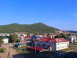 Zakamensk town center | |
Location of Zakamensk 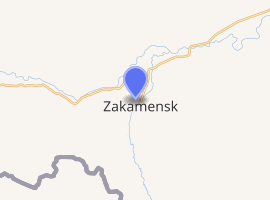
| |
 Zakamensk Location of Zakamensk .svg.png) Zakamensk Zakamensk (Republic of Buryatia) | |
| Coordinates: 50°23′N 103°18′E | |
| Country | Russia |
| Federal subject | Buryatia[1] |
| Administrative district | Zakamensky District[1] |
| Town | Zakamensk[1] |
| Founded | 1893 |
| Town status since | 1944 |
| Area | |
| • Total | 59.22 km2 (22.86 sq mi) |
| Elevation | 1,100 m (3,600 ft) |
| Population | |
| • Total | 11,524 |
| • Estimate (2018)[3] | 11,164 (-3.1%) |
| • Density | 190/km2 (500/sq mi) |
| • Capital of | Zakamensky District[1], Town of Zakamensk[1] |
| • Municipal district | Zakamensky Municipal District[4] |
| • Urban settlement | Zakamensk Urban Settlement[4] |
| • Capital of | Zakamensky Municipal District[4], Zakamensk Urban Settlement[4] |
| Time zone | UTC+8 (MSK+5 |
| Postal code(s)[6] | 671950, 671959 |
| Dialing code(s) | +7 301370 |
| OKTMO ID | 81621101001 |
History
It was founded in 1893 as a mining settlement under the name of Gorodok. Mining of the local tungsten and molybdenum reserves began in 1933. Town status was granted to it in 1944. It was renamed Zakamensk in 1959, from the Russian term Zakamen which had been used for the region since the 17th century. The word means beyond the rocks in Russian, referring to its location beyond the Khamar-Daban mountains.
Administrative and municipal status
Within the framework of administrative divisions, Zakamensk serves as the administrative center of Zakamensky District.[1] As an administrative division, it is incorporated within Zakamensky District as the Town of Zakamensk.[1] As a municipal division, the Town of Zakamensk and Kholtosonsky Selsoviet are incorporated within Zakamensky Municipal District as Zakamensk Urban Settlement.[4]
History of the municipal divisions
Kholtosonsky Selsoviet used to be municipally incorporated as Kholtosonskoye Rural Settlement, but the latter was merged into Zakamensk Urban Settlement on July 18, 2015.
Economy and transportation
The town's economy relies mainly on the mining and processing of metal ores, which are then mainly transported to smelters in the Ural Mountains. There is road from Zakamensk to Dzhida railway station, 253 kilometers (157 mi) to the east on the Trans-Mongolian Railway.
References
Notes
- Resolution #43
- Russian Federal State Statistics Service (2011). "Всероссийская перепись населения 2010 года. Том 1" [2010 All-Russian Population Census, vol. 1]. Всероссийская перепись населения 2010 года [2010 All-Russia Population Census] (in Russian). Federal State Statistics Service.
- "26. Численность постоянного населения Российской Федерации по муниципальным образованиям на 1 января 2018 года". Federal State Statistics Service. Retrieved January 23, 2019.
- Law #985-III
- "Об исчислении времени". Официальный интернет-портал правовой информации (in Russian). June 3, 2011. Retrieved January 19, 2019.
- Почта России. Информационно-вычислительный центр ОАСУ РПО. (Russian Post). Поиск объектов почтовой связи (Postal Objects Search) (in Russian)
- Russian Federal State Statistics Service (May 21, 2004). "Численность населения России, субъектов Российской Федерации в составе федеральных округов, районов, городских поселений, сельских населённых пунктов – районных центров и сельских населённых пунктов с населением 3 тысячи и более человек" [Population of Russia, Its Federal Districts, Federal Subjects, Districts, Urban Localities, Rural Localities—Administrative Centers, and Rural Localities with Population of Over 3,000] (XLS). Всероссийская перепись населения 2002 года [All-Russia Population Census of 2002] (in Russian).
- "Всесоюзная перепись населения 1989 г. Численность наличного населения союзных и автономных республик, автономных областей и округов, краёв, областей, районов, городских поселений и сёл-райцентров" [All Union Population Census of 1989: Present Population of Union and Autonomous Republics, Autonomous Oblasts and Okrugs, Krais, Oblasts, Districts, Urban Settlements, and Villages Serving as District Administrative Centers]. Всесоюзная перепись населения 1989 года [All-Union Population Census of 1989] (in Russian). Институт демографии Национального исследовательского университета: Высшая школа экономики [Institute of Demography at the National Research University: Higher School of Economics]. 1989 – via Demoscope Weekly.
Sources
- Правительство Республики Бурятия. Постановление №431 от 18 ноября 2009 г. «О реестре административно-территориальных единиц и населённых пунктов Республики Бурятия», в ред. Постановления №573 от 13 ноября 2015 г. «О внесении изменений в Постановление Правительства Республики Бурятия от 18.11.2009 №431 "О реестре административно-территориальных единиц и населённых пунктов Республики Бурятия"». Вступил в силу 18 ноября 2009 г. Опубликован: "Бурятия", №216, Официальный вестник №120, 21 ноября 2009 г. (Government of the Republic of Buryatia. Resolution #431 of November 18, 2009 On the Registry of the Administrative-Territorial Units and the Inhabited Localities of the Republic of Buryatia, as amended by the Resolution #573 of November 13, 2015 On Amending Resolution #431 of November 18, 2009 of the Government of the Republic of Buryatia "On the Registry of the Administrative-Territorial Units and the Inhabited Localities of the Republic of Buryatia". Effective as of November 18, 2009.).
- Народный Хурал Республики Бурятия. Закон №985-III от 31 декабря 2004 г. «Об установлении границ, образовании и наделении статусом муниципальных образований в Республике Бурятия», в ред. Закона №1411-V от 14 октября 2015 г. «О внесении изменений в Закон Республики Бурятия "Об установлении границ, образовании и наделении статусом муниципальных образований в Республике Бурятия"». Вступил в силу со дня официального опубликования. Опубликован: "Бурятия", №1, Официальный вестник №1, 12 января 2005 г. (People's Khural of the Republic of Buryatia. Law #985-III of December 31, 2004 On Establishing the Borders, Creating, and Granting a Status to the Municipal Formations in the Republic of Buryatia, as amended by the Law #1411-V of October 14, 2015 On Amending the Law of the Republic of Buryatia "On Establishing the Borders, Creating, and Granting a Status to the Municipal Formations in the Republic of Buryatia". Effective as of the day of the official publication.).
Administrative divisions of the Republic of Buryatia | |||
|---|---|---|---|
Capital: Ulan-Ude • Rural localities | |||
| Districts | |||
| Cities and towns (all levels) | |||
| Urban-type settlements | |||