Ivolginsky District
Ivolginsky District (Russian: Иволгинский райо́н; Buryat: Эбилгын аймаг, Ebilgyn aimag) is an administrative[1] and municipal[5] district (raion), one of the twenty-one in the Republic of Buryatia, Russia. It is located in the center of the republic. The area of the district is 2,660 square kilometers (1,030 sq mi).[2] Its administrative center is the rural locality (a selo) of Ivolginsk.[1] As of the 2010 Census, the total population of the district was 37,983, with the population of Ivolginsk accounting for 19.4% of that number.[3]
Ivolginsky District Иволгинский район | |
|---|---|
| Other transcription(s) | |
| • Buryat | Эбилгын аймаг |
 Ivolginskoye gorodishche, an archaeological site in Ivolginsky District | |
 Flag  Coat of arms | |
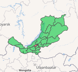
Location of Ivolginsky District in the Buryat Republic | |
| Coordinates: 51°45′N 107°17′E | |
| Country | Russia |
| Federal subject | Republic of Buryatia[1] |
| Established | August 25, 1939 (first),[2] August 1985 (second)[2] |
| Administrative center | Ivolginsk[1] |
| Area | |
| • Total | 2,660 km2 (1,030 sq mi) |
| Population | |
| • Total | 37,983 |
| • Estimate (2018)[4] | 54,574 (+43.7%) |
| • Density | 14/km2 (37/sq mi) |
| • Urban | 0% |
| • Rural | 100% |
| Administrative structure | |
| • Administrative divisions | 4 Selsoviets, 2 Somons |
| • Inhabited localities[1] | 28 Rural localities |
| Municipal structure | |
| • Municipally incorporated as | Ivolginsky Municipal District[5] |
| • Municipal divisions[5] | 0 Urban settlements, 6 Rural settlements |
| Time zone | UTC+8 (MSK+5 |
| OKTMO ID | 81622000 |
| Website | http://ivolginsk.info |
| 2010 Census | 37,983[3] |
|---|---|
| 2002 Census | 26,801[7] |
| 1989 Census | 24,703[8] |
Geography
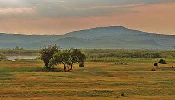
The district is located in central Buryatia, mostly on the left bank of the Selenga River, in the geographical region of the Selenga Highlands.
History
The district was first established on August 25, 1939.[2] In 1954, it was split between Selenginsky, Tarbagataysky, and Ulan-Udensky Districts, as well as Sovetsky City District of Ulan-Ude.[2] In August 1985, Ivolginsky District was re-established.[2]
Administrative and municipal status
Within the framework of administrative divisions, Ivolginsky District is one of the twenty-one in the Republic of Buryatia.[1] The district is divided into four selsoviets and two somons, which comprise twenty-eight rural localities.[1] As a municipal division, the district is incorporated as Ivolginsky Municipal District.[5] Its four selsoviets and two somons are incorporated as six rural settlements within the municipal district.[5] The selo of Ivolginsk serves as the administrative center of both the administrative[1] and municipal[5] district.
References
Notes
- Resolution #431
- Official website of the Buryat Republic. Information about Ivolginsky District (in Russian)
- Russian Federal State Statistics Service (2011). "Всероссийская перепись населения 2010 года. Том 1" [2010 All-Russian Population Census, vol. 1]. Всероссийская перепись населения 2010 года [2010 All-Russia Population Census] (in Russian). Federal State Statistics Service.
- "26. Численность постоянного населения Российской Федерации по муниципальным образованиям на 1 января 2018 года". Federal State Statistics Service. Retrieved January 23, 2019.
- Law #985-III
- "Об исчислении времени". Официальный интернет-портал правовой информации (in Russian). June 3, 2011. Retrieved January 19, 2019.
- Russian Federal State Statistics Service (May 21, 2004). "Численность населения России, субъектов Российской Федерации в составе федеральных округов, районов, городских поселений, сельских населённых пунктов – районных центров и сельских населённых пунктов с населением 3 тысячи и более человек" [Population of Russia, Its Federal Districts, Federal Subjects, Districts, Urban Localities, Rural Localities—Administrative Centers, and Rural Localities with Population of Over 3,000] (XLS). Всероссийская перепись населения 2002 года [All-Russia Population Census of 2002] (in Russian).
- "Всесоюзная перепись населения 1989 г. Численность наличного населения союзных и автономных республик, автономных областей и округов, краёв, областей, районов, городских поселений и сёл-райцентров" [All Union Population Census of 1989: Present Population of Union and Autonomous Republics, Autonomous Oblasts and Okrugs, Krais, Oblasts, Districts, Urban Settlements, and Villages Serving as District Administrative Centers]. Всесоюзная перепись населения 1989 года [All-Union Population Census of 1989] (in Russian). Институт демографии Национального исследовательского университета: Высшая школа экономики [Institute of Demography at the National Research University: Higher School of Economics]. 1989 – via Demoscope Weekly.
Sources
- Правительство Республики Бурятия. Постановление №431 от 18 ноября 2009 г. «О реестре административно-территориальных единиц и населённых пунктов Республики Бурятия», в ред. Постановления №573 от 13 ноября 2015 г. «О внесении изменений в Постановление Правительства Республики Бурятия от 18.11.2009 №431 "О реестре административно-территориальных единиц и населённых пунктов Республики Бурятия"». Вступил в силу 18 ноября 2009 г. Опубликован: "Бурятия", №216, Официальный вестник №120, 21 ноября 2009 г. (Government of the Republic of Buryatia. Resolution #431 of November 18, 2009 On the Registry of the Administrative-Territorial Units and the Inhabited Localities of the Republic of Buryatia, as amended by the Resolution #573 of November 13, 2015 On Amending Resolution #431 of November 18, 2009 of the Government of the Republic of Buryatia "On the Registry of the Administrative-Territorial Units and the Inhabited Localities of the Republic of Buryatia". Effective as of November 18, 2009.).
- Народный Хурал Республики Бурятия. Закон №985-III от 31 декабря 2004 г. «Об установлении границ, образовании и наделении статусом муниципальных образований в Республике Бурятия», в ред. Закона №1411-V от 14 октября 2015 г. «О внесении изменений в Закон Республики Бурятия "Об установлении границ, образовании и наделении статусом муниципальных образований в Республике Бурятия"». Вступил в силу со дня официального опубликования. Опубликован: "Бурятия", №1, Официальный вестник №1, 12 января 2005 г. (People's Khural of the Republic of Buryatia. Law #985-III of December 31, 2004 On Establishing the Borders, Creating, and Granting a Status to the Municipal Formations in the Republic of Buryatia, as amended by the Law #1411-V of October 14, 2015 On Amending the Law of the Republic of Buryatia "On Establishing the Borders, Creating, and Granting a Status to the Municipal Formations in the Republic of Buryatia". Effective as of the day of the official publication.).
Administrative divisions of the Republic of Buryatia | |||
|---|---|---|---|
Capital: Ulan-Ude • Rural localities | |||
| Districts | |||
| Cities and towns (all levels) | |||
| Urban-type settlements | |||